Mapping Storm Hotspots, Where the World’s Tempests are Brewed
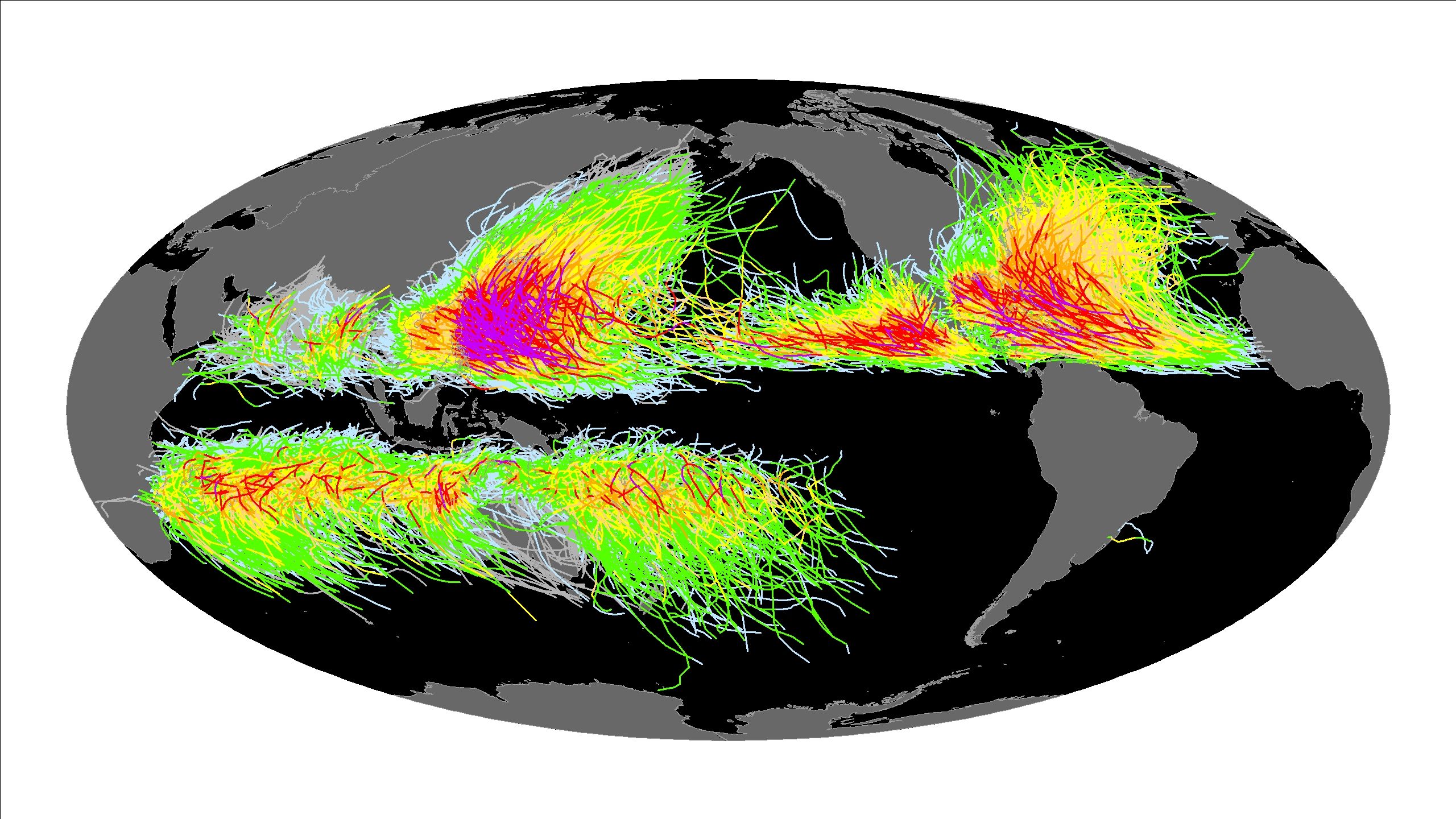
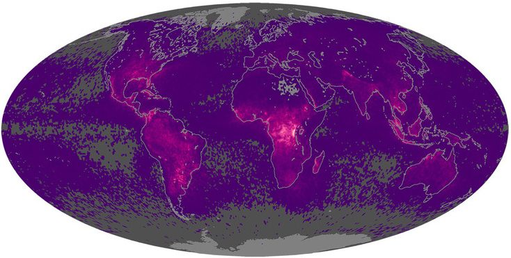 Global lightning map based on satellite observations between 1995-2013. (Photo: NASA/Public Domain)
Where do hurricanes corkscrew into being? Where does the black dervish of a tornado tend to roar up? And where do the elements of sunlight and moisture and breeze all come together to summon a big thunderhead? Storms can pop up anyplace, but certain corners of the Earth, known as storm nurseries, breed them over and over.
These hotspots can seem remote or downright unremarkable. But even a farflung tract of ocean or a sweep of featureless prairie can incubate maelstroms of destruction, sometimes thousands of miles away.
Meteorologists keep a wary eye on storm nurseries like these to forecast tempests like hurricanes, tornadoes, and blizzards. Below are detailed maps highlighting some of these fraught weather factories.
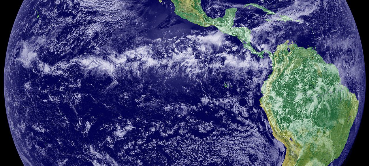 A satellite photo showing the Intertropical Convergence Zone (ITCZ). (Photo: NASA/Public Domain)
The world’s most relentless birthplace for thunderstorms is the sultry equatorial belt called the Intertropical Convergence Zone (ITCZ), where the trade winds from both hemispheres merge. Sailors have long referred to this area as “the doldrums.”
Over the oceans, the ITCZ mostly produces chronic rain squalls. Where the belt crosses South America, Africa, and Southeast Asia, though, it harbors much stronger thunderstorms, producing some of the most staggering lightning shows on Earth.
On the map at the top of this article, the zones of heaviest annual lighting stand out in radioactive purple. The most vigorous large-scale nursery—unmistakable on the map—is the Congo Basin in central Africa, where daily thunderheads produce some 230 lightning flashes per square kilometer annually.
Only one spot in the New World, though, goes toe-to-toe with the Congo in terms of lighting production: Lake Maracaibo in Venezuela. Here the evening skies spit electricity so reliably—with close to 250 flashes per square kilometer per year—that Caribbean mariners used it for navigation.
 Global tornado heartland: U.S. tornadoes, 1950-2014 (Photo: NOAA Storm Prediction Center)
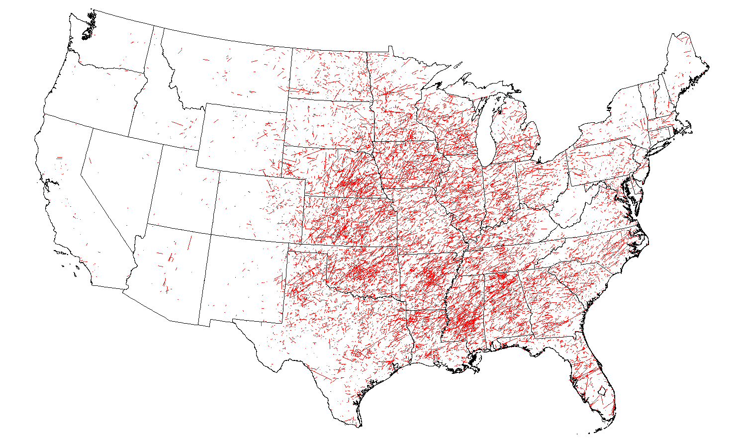
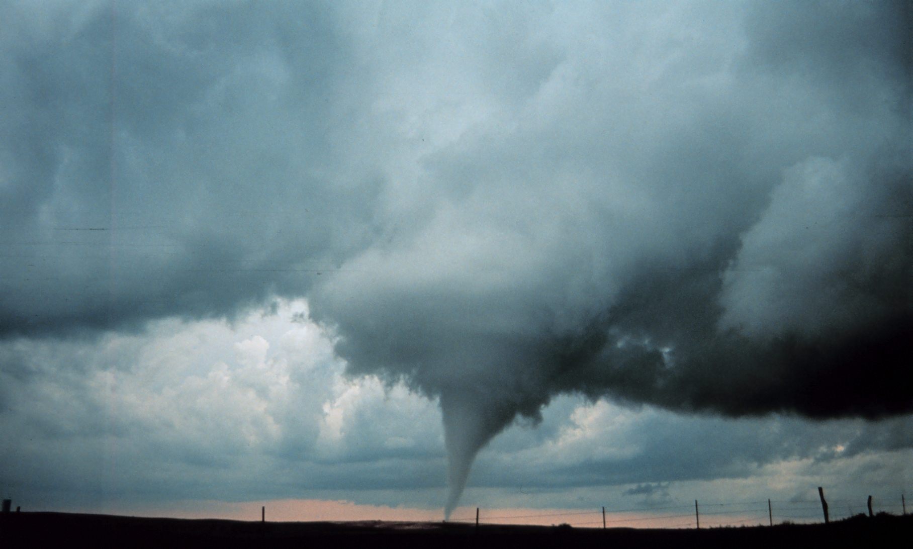
Great summertime thunderstorms, meanwhile, breed prolifically in the vast reaches of the central United States—basically a sprawling flatland boxing ring for continental and maritime air masses to duke it out. This sets the stage for some of the world’s most brutal weather, including by far the most numerous and severe tornadoes.
Florida sees a healthy dose of annual tornadoes, but the most violent twisters (usually spawned in rotating thunderstorms called supercells) tend to form in two major nurseries: the Plains Tornado Alley, a swath stretching from central Texas to Nebraska and Iowa; and Dixie Alley, anchored by the lower Mississippi Valley and the Gulf Coast.
The grasslands of the South American Pampas are the planet’s second-greatest tornado hotbed. The twister-prone strip from southern Brazil to central Argentina is sometimes called Pasillo de los Tornados—the Tornado Corridor.
A map showing tropical cyclone tracks. (Photo: Climate.gov)
As the map above shows, tropical cyclones—also called hurricanes and typhoons—form in equatorial waters and hitch a ride on the easterly trade winds. The world’s hurricane cradles typically fall within 10 and 30 degrees of latitude in the warmest areas of the North Atlantic, Pacific, and Indian oceans. However, the equator itself doesn’t breed any cyclones, because one important ingredient for hurricane formation is winds warped by the earth’s rotation; that spin effect is nil right along the equator.
Some of today’s fiercest hurricanes are born near the Cape Verde islands, a group of ten volcanic islands 350 miles off the coast of West Africa. These cyclones in the North Atlantic pack a punch partly because they have such a long, open ramp of warm waters to gather steam across.
The seeds for most Atlantic hurricanes, including those Cape Verde monsters, are subtle atmospheric disturbances called easterly waves that pulse off the African continent; recent research suggests thunderstorms over Africa may actually spark these waves in the first place. (Which means meteorologists might be able to look at lightning outbreaks over Africa for a heads-up on other Atlantic cyclones a week in the future.)
The typhoons of the northwestern Pacific are even more ferocious and frequent than their Atlantic cousins. Here, the main typhoon breeding ground—a migratory low-pressure corridor called the monsoon trough—slants across the Philippine Sea southeast into Micronesia. The map below shows the track of the biggest and most intense tropical cyclone on record, Typhoon Tip, which emerged in the monsoon trough in October 1979. At its peak near Guam, this super-sized whirlwind stretched 1,380 miles across and spun at 190 miles per hour.
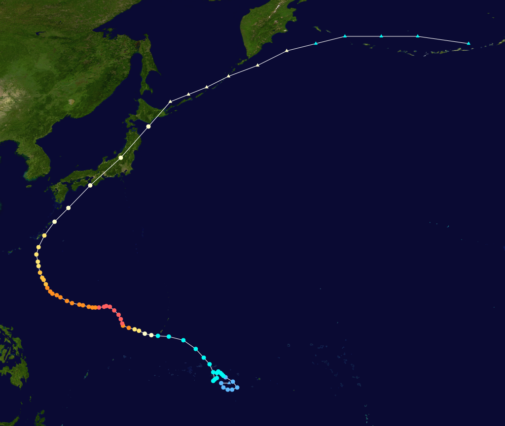
The track of the strongest tropical cyclone ever recorded, 1979’s Typhoon Tip, born in the monsoon trough of the western North Pacific (Photo: Public Domain/WikiCommons)
Everyone remembers when temperate places are suddenly hit with dramatic winter weather. This phenomenon is born in the polar front, where cold air from the poles and warm air from the tropics meet. Waves along the polar front brew low-pressure howlers called extratropical cyclones, complete with gales that can approach the breadth of a small continent. These clashes are strongest in winter.
The fearsome nor’easters that slam the East Coast are extratropical cyclones that often arise in the Gulf of Mexico or the Gulf Stream off the mid-Atlantic coast (particularly around the Carolinas). If conditions and storm tracks align, these big blows can deliver monumental snowfalls.
Hurricanes and extratropical cyclones have different fuel sources, but they sometimes shape shift into one another. Some North Atlantic hurricanes that spiral poleward are reborn as mid-latitude storms. And a handful of extra tropical cyclones that stall over warm waters become hurricanes.
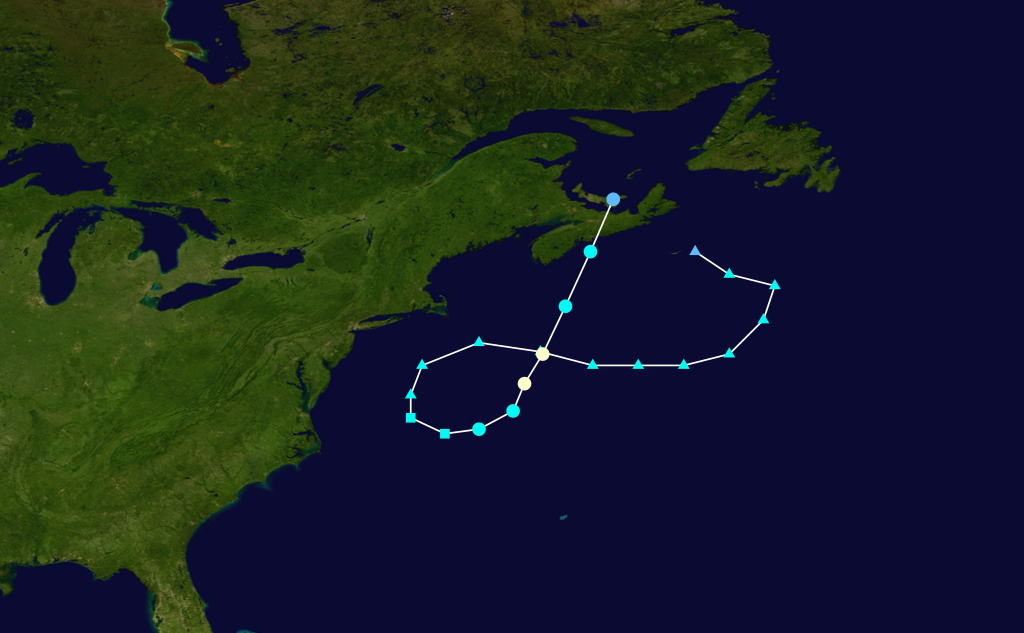 The wacky (and violent) path of the “Perfect Storm,” encompassing both its nor’easter and hurricane incarnations (Image: Public Domain/WikiCommons)
The notorious “Perfect Storm” of 1991 blurred the lines more than once: As an epic nor’easter in the western Atlantic, it swallowed a dying hurricane called Hurricane Grace. Then, drifting southward over the Gulf Stream, it spawned a brand-new tropical storm in its heart. This eventually gained hurricane status and trundled northeastward, partly retracing its parent storm’s path and squalling out over eastern Canada, but not before causing more than $200 million worth of damage.
The storm nurseries these maps depict aren’t just ferocious inconveniences, though they’re responsible for massive chaos and upheaval. The furies they send out into the world also help redistribute energy in the atmosphere, address the heat imbalance between the tropics and the poles, and vanquish drought with torrential rains.
Charged though they are with latent destructive power, we ought to pay these genesis zones a little respect.
A tornado spawned by a supercell thunderstorm in Oklahoma in 1999 (Photo: NOAA/Public Domain)
Map Monday highlights interesting and unusual cartographic pursuits from around the world and through time. Read more Map Monday posts.


Follow us on Twitter to get the latest on the world's hidden wonders.
Like us on Facebook to get the latest on the world's hidden wonders.
Follow us on Twitter Like us on Facebook