Reporting from London - Extraordinary Maps at the British Library
.jpg)
I’m in London to join team Steppe On It! for the launch of the 2010 Mongol Rally. But before I leave for the coast tomorrow, I had just one day for London explorations, and I was dead set on finding some of the fantastical and unusual places that this city has to offer.
There were some tough choices to make and I had to plan out a route that would allow me to see as much as possible during my brief stay before heading south. After pouring over my options, I decided to start at the British Library’s “Magnificent Maps” exhibit to satiate my love of maps. I also stopped at the Wellcome Collection, the home and personal museum of Sir John Soane, the eccentric assemblage of all things formaldehyde at the Hunterian Museum, and sipped a refreshing glass of wine from London’s oldest wine bar (Thanks to all of the suggestions of places to see that came in on Twitter and Facebook).
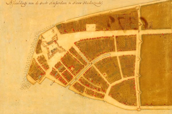
The British Library and the Magnificent Maps exhibit, as you can imagine, was astounding. The exhibit is a comprehensive look at centuries of cartography and illuminated the interplay between the symbolism and geography that are definitive of the maps of antiquity. The intersection of art and utility were brought to life by scenes from mythology, intricate coastlines and imaginative creatures from the deepest recesses of the artists’ imagination.
 In the age of Google, when maps of the world are merely a click away, and nothing is left up to the minds eye, I took a step back from the impressive displays and pictured scenes of a time gone by. Aristocrats with their opulent Cabinets of Curiosities sharing their collection with their closest friends, scenes of kings exalted as they exuded their power and influence with maps of their empire adorning the walls of their palace galleries and the socio-psychological influence of a propaganda map, produced in Vichy France during WWII, depicting Winston Churchill as a demonic octopus.
But as I strolled through the exhibit, I came upon one map in particular that truly made my jaw drop. It was the Klencke Atlas—the largest atlas in the world. Standing five feet tall and six feet wide, it is truly a sight to see. It contains 37 large wall maps in an immaculate binding and was considered to encapsulate the knowledge of the whole world. The atlas was presented as a gift to Charles II in 1660 from Dutch merchants following the restoration of the throne after the English Civil War. A memorable sight to say the least.
A visit to the Magnificent Maps exhibit was a fitting preamble to the Mongol Rally. The exhibiti is at the British Library and runs now through September 19th, 2010
More info at the Magnificent Maps website. You can also read the curator’s blog here
NEXT UP: Mongol Rally launch day!
Atlas Obscura is a proud sponsor of Steppe On It!’s attempt to complete the 2010 Mongol Rally, raising money for Mercy Corps. Seth Teicher has joined them for the first leg of their adventure. Previously:
Elsewhere:
- Team Steppe On It, Twitter is here , Facebook is here , Mongol Rally site is here. Czechout website is here


Follow us on Twitter to get the latest on the world's hidden wonders.
Like us on Facebook to get the latest on the world's hidden wonders.
Follow us on Twitter Like us on Facebook