Guide to Islands You Don’t Want to Visit, Pt.2


When we think of visiting islands, what comes to mind is blue water, tropical laziness, and big cocktails with tiny umbrellas, a tantalizing escape from the hustle and bustle of our daily lives.
These are not those little slices of heaven. These islands hide dangerous secrets. From manmade disasters to wild weather and fatal predators, these islands are only for those adventure seekers with a bit of a death wish, or a lot of preparation and gear. There are in fact so many islands in the world that are dangerous or best avoided, that one guide was simply not enough, so to follow up our Guide to Islands You Never Want to Visit, welcome to Atlas Obscura’s Guide to Islands You Don’t Want to Visit, Part 2 - and remember, sometimes you should never get off the boat.
ANDERSEN AIR FORCE BASE
Yigo, Guam
Where the solution may be even creepier than the problems that slither and crawl across the island
Naval helicopters over Guam (via Wikimedia)
If you have even the smallest case of Arachnophobia, the beauty of Guam is not for you. It is estimated that there are 40 times more spiders in the jungles of Guam than on any other island in the area and their webs are up to 50% larger than those found in other locations. Their population is booming due to another predator — the invasive brown tree snake.
The brown tree snake is thought to have landed in Guam during World War II, after stowing away on vessels from Australia, Papua New Guinea, and the Solomon Islands. The snake has no natural predators in Guam, so millions now slither through the jungles. Estimates of the snake population put 20 to 30 snakes in every acre on the island, and they cause frequent power outages, infrastructure damage, and the occasional non-lethal bite. The reptile horde has eaten 10 of the 12 native bird species right out of existence, and this has led to a nightmarish rise in the spider population.
The dreaded Brown Tree Snake in the jungles of Guam (via Wikimedia)
In order to inhibit the snakes from spreading to other islands and to keep the lovely beaches and resorts relatively slither and web free, Guam and its US counterparts came up with a rather interesting solution. Acetaminophen (commonly found in Tylenol) is deadly to the brown tree snake, and to mice. So in early 2013, after feeding a fatal dose to thousands of mice, they strapped tiny parachutes and pieces of cardboard to the rodents before dropping them into more than 100 acres of jungle on the Andersen Air Force Base.The hope is that they will be fatally devoured by some of the two to three million hungry brown snakes. It appeared to work in the first test run back in 2010, and they’re hoping for a larger and more widespread result this time.
If it works, the idea is that as the snakes perish, the birds can be brought back to eat the spiders. Whatever scenario, it will certainly leave thousands of dead and decomposing mice hanging in the trees. Considering the climate and the tropical heat, if the snakes don’t fall for the poisoned bait, things could get just that much creepier, and smellier. Now doesn’t that just sound like the perfect island getaway? We didn’t think so either.
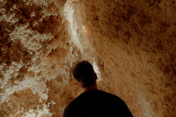
RAMREE ISLAND
Ramree Island, Myanmar
Where hungry man-eating crocodiles, malaria carrying mosquitoes, and stinging scorpions get together for meals
The swamps on Ramree Island (photograph by Robert Appleton)
Ramree Island is located right off the coast of Myanmar. It was made famous by a strange and deadly occurrence that followed a battle between the British and the Japanese during World War II. The British began an aggressive attack on the Japanese camps on Ramree on January 26, 1945. When the Japanese were forced to retreat into the marshlands and mangroves that surround the island, most mysteriously disappeared. They are rumored to have met their maker by the giant saltwater crocodiles that inhabit the area. The crocodiles are reported to have feasted on hundreds of soldiers, and very few men were pulled out alive from the swamps. Ramree has since maintained the bragging rights for being the location of the “Greatest Disaster Suffered by Humans Due to Animals” in the Guinness Book of World Records.
Though locals and historians dispute the idea of a massive massacre by the saltwater crocodiles, it is true that somewhere between 500 and 1,000 soldiers entered the marshes, and only around 20 were found alive. Those survivors told wild tales of their fellow soldiers’ screams, agonizing deaths, and the snapping jaws of the world’s largest reptiles. Stanley Wright, a participant in that battle, describes the incident in his book, Wildlife Sketches Near and Far: “The scattered rifle shots in the pitch black swamp punctured by the screams of wounded men crushed in the jaws of huge reptiles, and the blurred worrying sound of spinning crocodiles made a cacophony of hell that has rarely been duplicated on earth.”
Saltwater crocodile, not on Ramree Island — sorry, they get around (photograph by thinboyfatter/Flickr user)
These could be tall tales designed to mask the escape of enemy fighters. They could also be hallucinations and fever dreams since the mosquitoes on Ramree are infected with various malaria strains and thousands of poisonous scorpions run rampant on the island. Either way, the highly territorial saltwater crocodiles do still live in vast numbers around Ramree Island, and they are not finicky eaters - they can and will eat almost anything that enters their territory, including the occasional human.
As if the hostile animals weren’t enough, there’s been an increase in volcanic rumblings on the island, with small streams of lava emerging along the fault lines. Though geologists maintain there is little or no risk from the recent activity, when combined with malaria-infected mosquitoes, stinging scorpions, and man-eating reptiles, this beautiful island paradise seems anything but.
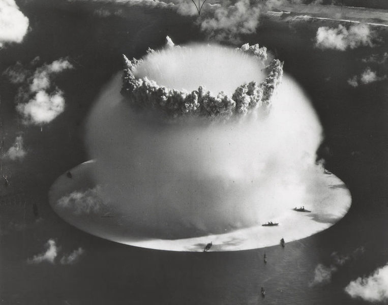
BIKINI ATOLL
Marshall Islands
A tragic casualty of war where you’ll want a geiger counter, rather than a beach towel
Abandoned beaches of Bikini Atoll (via wikimedia)
The Bikini Atoll is a beautiful oasis of overgrown plant life, pristine beaches, and fertile and crystal clear blue water. The temptation is even enhanced by the fact that the tiny bathing suits which the world associates with beach culture were named after it. Don’t let this paradise fool you though — Bikini has a hidden and tragic secret. The lush beauty of the Bikini Atoll comes at a terrible price.
The natives of Bikini were removed by the US government in the 1940s, and are still compensated for the loss of their homes and towns. As part of the Pacific Proving Grounds, a total of 23 nuclear tests were conducted in this area over a 12-year period, rendering the island uninhabitable. When Bikini was prematurely deemed safe and the population returned, chemical and toxic levels rose to unhealthy degrees. The number of miscarriages and stillbirths rose sharply, the people were getting sicker, and the wells were contaminated with chemicals leftover from the testing. The natives were soon relocated again — which is another reason why the island regrowth is so rampant and unchecked.
The Baker explosion on Bikini Atoll, 1946 (via Wikimedia)
Though Bikini has technically reopened for some tourism, such as scuba diving in the lagoon and sport fishing off the shore, the vegetation is still not safe for consumption and the clear waters are home for a number of sharks, barracuda, and other large predatory fish. The profits from the limited tourism go to the relocated residents who still hope to go home someday and to share the beauty of this place with everyone.
There are reasons for that hope, as the potential for rehabilitating the island has improved over recent years. The International Atomic Energy Agency found that Cesium-137 levels are dropping considerably faster than anyone expected, but the money needed for removing the topsoil and the immense cleanup that would guarantee the island’s safety just isn’t there. The possibility for a healthy homecoming or extended stay on Bikini Atoll is unfortunately still unlikely for a long time to come.
THILAFUSHI
Thilafushi, Maldives
The toxic and dirty solution to keeping resort islands clean and pristine
Thilafushi from the air (via wikimedia)
Thilafushi is located to the west of Malé in the glorious Maldives — a revamped island chain in the Indian Ocean. The Maldives have islands that boast such beauty and luxury that people from celebrities to kings have an island getaway there.
So how do you keep such a heavily traveled island chain so clear and pristine? You ship all that unsightly refuse somewhere else. This is where the toxic island of Thilafushi enters the picture. Thilafushi is the dumping grounds for Malé and all the other islands in this area. So much garbage is dumped there that the island grows approximately one square meter per day. Thilafushi began as a little sand bar and has been built up with landfill to become what it is — a Rubbish Island.
Rubbish Island (photograph by Hani Amir)
When it was designated as a dump in the early 1990s, initially there was no segregation of the types of waste delivered. This led to toxic materials being mixed with regular trash, some of which has ended up in the ocean and led to concerns about the health of both the ocean life and the humans that live in the area. Even now, toxic spills are all too frequent and the constant fires on the island spew potentially hazardous black smoke into the air 24 hours a day. The number of industrial leases being offered on the island has doubled in the last decade, and Thilafushi is now home to heavy industry, such as a plant that bottles methane gas and a cement factory. Rotating workers in these factories are housed in concrete dorms — and are not Maldivian, because no natives would stay there.
It has been called a toxic time bomb by local environmental groups. Though plans have been made to rehabilitate the island, none have come to fruition and it continues to grow.
NORTH ATLANTIC GARBAGE ISLAND
Sargasso Sea, Atlantic Ocean
Because the Pacific Garbage Patch can’t grow old alone
Plastics in the ocean (via Mercopress)
Speaking of rubbish islands, though the Pacific Garbage Patch has gotten all of the attention and press, its younger relative in the North Atlantic is playing catch up with a vengeance. This whirling mass of plastics and other trash known as North Atlantic Garbage Island sits in the Sargasso Sea, constantly being fed by four currents and growing every day.
This floating disaster is estimated to be hundreds of kilometers wide, with roughly 200,000 pieces of garbage in each square kilometer. Although its east-west span is unknown, the expanding patch covers the area between 22 and 38 degrees north latitude— which is roughly the distance from Virginia to Cuba. It’s comprised mostly of plastics and tiny pieces of trash that weigh less than a paperclip which have been blown out of landfills or carelessly tossed on beaches. Because the trash is so minuscule and the currents and waves are constantly in motion, it is not seen by satellites or to the naked eye even if you are right on top of it, unless you happen to be there on a windless day.
Litter on the Atlantic Seaboard (photograph via Wkimedia)
This out of sight, out of mind situation is another reason most people are unaware of the growing threat. Students have been studying this patch extensively since 1972 and watching in horror as the refuse grows. They deploy thousands of fine-meshed nets to catalog the pieces of trash and plastic that are intertwined with the drifting plant life and animals, but as of yet, there does not seem to be a viable cleanup solution.
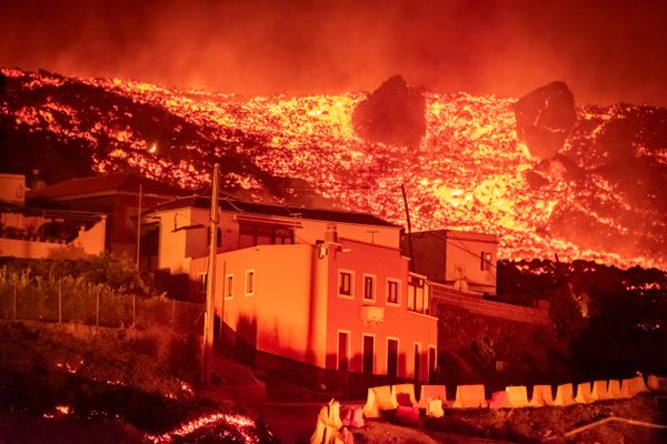
EL HIERRO
Frontera, Canary Islands
Live by the volcano, die by the volcano
Coastal village on El Hierro (via Wikimedia)
El Hierro off the coast of Africa is one of the Canary Islands. It rose to the surface over a million years ago due to volcanic activity, and that activity has been swelling at an alarming rate since 2011. Despite being the smallest and youngest island in the chain, it has the most visible volcanic scars in the area, boasting over 500 cones and approximately 70 caves and volcanic galleries. It is a wild and beautiful island of lush greenery, protected habitats, and rolling waves, but right under the surface of that crystal clear water lies an ever-growing danger.
Lava fields and cones on El Hierro (photograph by Bjoern.Hoernitz)
The increasingly active El Hierro underwater volcano just offshore has spewed about 120,000 swimming pools’ worth of lava into the ocean, sent ash and gas into the air and sea, and caused over 15,000 earthquakes in the last two years. To say that El Hierro has woken up is an understatement and its rumblings are just getting louder. Scientists have been studying the underwater volcano intensely; residents have been temporarily evacuated numerous times before returning again to their stunning island and their homes. During the last eruption, upwelling lava and gas killed off fish and plankton and the water heated up by as much as 65 degrees Fahrenheit, becoming noticeably more acidic.
There are many signs of a continued threat from this volcano. Earthquakes are getting stronger and the probability of landslides, resulting tsunamis, and other damage is rising. The island has seen an uplift of over 10 centimeters in the last 12 months and increases in seismic activity indicate that the volcano is growing ever more quickly and heading towards a vast eruption.
TILLAMOOK ROCK
Cannon Beach, Oregon
A cursed rock that has driven men to madness and provided no rest for the ghosts who remain
Terrible Tilly on Tillamook Rock (via Wikimedia)
Tillamook Rock, a small basalt rock off the coast of Oregon, is absolutely stunning from a distance. A lighthouse towers above the jutting rocks while white foamy waves crash all around its base. It evokes the romantic notion of a life saving passing ships in the night from certain doom on the rocky shore. However, this picturesque scene is anything but peaceful and has been abandoned to the masterful elements for years.
The lighthouse was first used in January of 1881 and was the most expensive lighthouse ever built in the west at that time. Tragically, the first light came a little late. Less than two weeks before it became operational, a boat crashed near the island, killing all 16 crew members. This incident, combined with the dangerous water and the erratic weather, earned the lighthouse the nickname of Terrible Tilly. Tilly had such brutal weather and utter isolation that it took a team of four just to keep the light on. Over the years, its reputation for being haunted or cursed grew and the constant storms broke windows, shattered lenses, eroded the rock, and drove some of the men into massive depression and madness. It’s reported that one keeper broke down and tried to kill another by feeding him ground up glass. Even with shorter rotations and longer breaks, the post was nearly impossible to fill so Terrible Tilly was decommissioned in 1957 and sold to a private group. Some of the owners visited their investment once and never returned, and shortly thereafter, Tillamook Rock was on the market again.
Waves pummeling Tillamook Rock (via Wikimedia)
After changing hands a few more times, in 1980 the buildings on Tillamook Rock were gutted and turned into the Eternity at Sea Columbarium. Though their license was revoked in 1999 and rejected again in 2005, Eternity at Sea continues to sell itself as a watery resting place and maintains a waiting list for their repository. There are believed to be about 30 occupied urns in the rogue columbarium, but the records are unclear. Even if it were known, access to the island is severely limited and without permissions and a helicopter, there is no way for loved ones to visit.
There have been no caretakers for decades and now the ravaged buildings and everything in them are under a mountain of guano, left by the generations of protected sea birds that roost on the island.
GEORGE TOWN
George Town, Cayman Islands
The ultimate destination of the rich and powerful is lovely, when it isn’t being pummeled by storms or drowning in the sea
Seven Mile Beach on the Cayman Islands (via Wikimedia)
The Cayman Islands, located about 150 miles south of Cuba, are a tropical playground for the obscenely rich, who come here for pristine Caribbean beaches, incredible diving, and to stash their cash in offshore accounts while avoiding the tax man. Most visitors are blissfully unaware of the other reputation of this jet set island - and that’s because being the hurricane capital of the world can be extremely bad for business.
According to storm watchers, Grand Cayman, the largest of the three Cayman isles, is hit or brushed by more hurricanes or high category storms than any other locale in the Atlantic basin, averaging a hurricane every 2.23 years. Over the last 150 years, tropical storms and hurricanes have smashed the entirely sea level island, often with terrifying results. 83% of buildings have been damaged and rebuilt at least once and 70% of all houses and dwellings have been reported as seriously damaged or unsafe at least once.
Hurricane signs at Rum Point on Grand Cayman (via Wikimedia)
However, after Hurricane Ivan decimated the island, drenching it in a foot of rain and leaving over a quarter of it submerged, Grand Cayman began a massive rebuilding process and was back to business as usual amazingly within a few weeks. That was not without controversy since the non-financial parts of the island took the better part of two years to return to normal. That’s still fantastic news for the island, since they only have about that much time between devastating storms.
So while there is a window of opportunity for the idyllic tropical vacation complete with champagne and caviar, keep a close eye on the weather if you’re planning a visit to the island. Also, perhaps leave your large stash of cash back home under a mattress, since we wouldn’t want it to get swept out to sea.
TREASURE ISLAND
San Francisco, California
The answer to the Bay Area’s population boom complete with million dollar views and radioactive waste
The million dollar view from Treasure Island (via Wikimedia)
San Francisco has been one of the most expensive places in the United States to live for years running, yet millions of people still flock to The City, as it is affectionately called by the locals. There have been many interesting solutions to the problem of how to make room for these people. The newest annex is an island full of big dreams and spectacular views. Housing plans and community gardens are already in full swing and with the planned 1.5 billion dollar development breaking ground in late summer 2013, it is being billed as one of the most gorgeous new communities on the West Coast.
Unfortunately, those tempting and wonderful ideas hide darker and more frightening truths. Treasure Island, named after the Robert Louis Stevenson novel, was built out of landfill dredged from the bottom of the bay that surrounds it, and it has been slowly returning to the water from whence it came. And for all of its concern with the environment, the truth is that it has been quietly battling radiation concerns for decades, due to its Naval past.
The Naval architecture is apparent in The Palace of Fine and Decorative Arts (via Wikimedia)
The US Navy acquired Treasure Island in the 1940s and proceeded to build a giant base that was used as repair and salvage operation for ships that may have been exposed to nuclear testing in the Pacific. It was also a training ground where a ship was intentionally doused with low-level radiation so that sailors could practice safely scrubbing it clean. Though the Navy claims that their cleanup and restoration has been effective on the island, a new report in 2012 by the Department of Public Health contradicts them and states that some portions of the island remain unhealthy. The report claims that potential risks are more widespread than originally thought and that the cleanup has consisted of many errors, finger pointing, and false steps.
This does not bode well for the planned 20,000+ new residents, shopping areas, theaters, and businesses that are hoping to call this little island home. Adding to the threat of radioactive chemicals is the very real possibility that in the case of another big earthquake — which this area is famous for — Treasure Island runs the risk of liquefaction. It could quite literally fall apart with at least a portion of it becoming liquid due to its landfill roots. Bottom line here is enjoy the spectacular view of San Francisco, but don’t buy into the idea of this beautiful island suburb — the rising levels of both Caesium-137 and the ocean make this investment shaky (so to speak) at best. As for those blooming community gardens? Maybe just stick to the closest off-island farmer’s market for your produce, just in case.
Want more dangerous island getaways? Check out Atlas Obscura’s first Guide to Islands You Never Want to Visit.


Follow us on Twitter to get the latest on the world's hidden wonders.
Like us on Facebook to get the latest on the world's hidden wonders.
Follow us on Twitter Like us on Facebook