How Early Megacities Emerged From the Jungles of Cambodia
And how instability, climate, and neglect drove their slow collapse.
This story is excerpted and adapted from Annalee Newitz’s Four Lost Cities: A Secret History of the Urban Age, published in February 2021 by W. W. Norton.
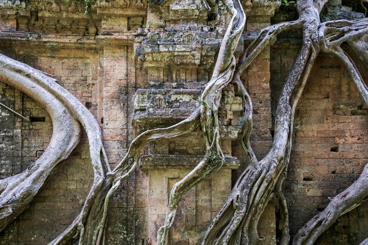
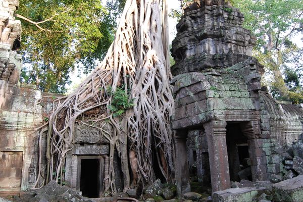
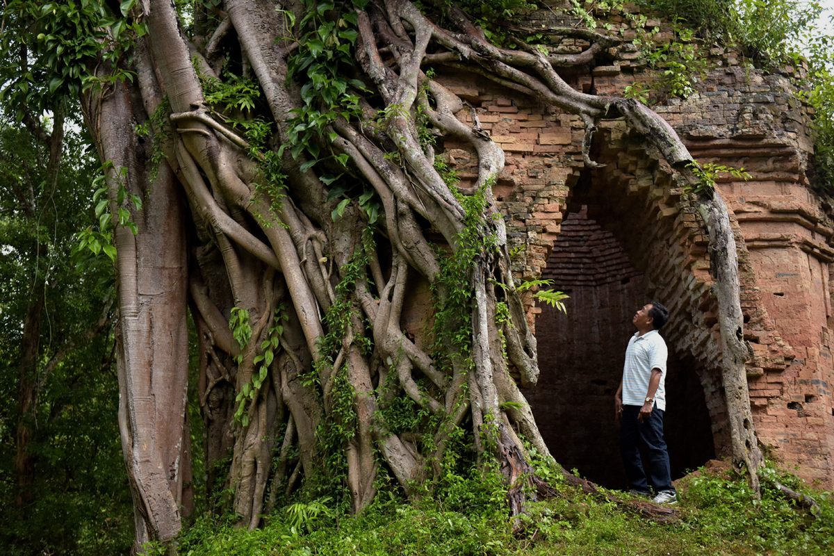
When I arrived in Phnom Penh during Cambodia’s dry season in January, I stumbled through the streets in a jet-lagged daze, barely seeing the dense city around me. My mind was on thousand-year-old Khmer temples, their golden facades crumbling into worn stone blocks and imprisoned by thickly braided tree roots. These structures, from the Khmer Empire’s capital at Angkor, have been synonymous with the myth of lost cities for at least two centuries. You can even find Lara Croft exploring the legendary ruins of the Angkorian temple Ta Prohm in the first Tomb Raider movie. But unlike Roman civilization, Khmer traditions are not lost or dead. The culture that blossomed at Angkor—a form of Theravada Buddhism combined with centralized state power—continues to shape many aspects of Cambodian life today. Once I’d gotten some sleep, I could see it on the streets of Phnom Penh, the city where Khmer royals fled in the 15th century as Angkor fell apart. Today, the nearly 600-year-old capital’s buildings are obscured by tangles of electrical cables instead of tree roots, and fences around modern-day palaces are topped with coiled razor wire so fine it shimmers in the sun like jewels.
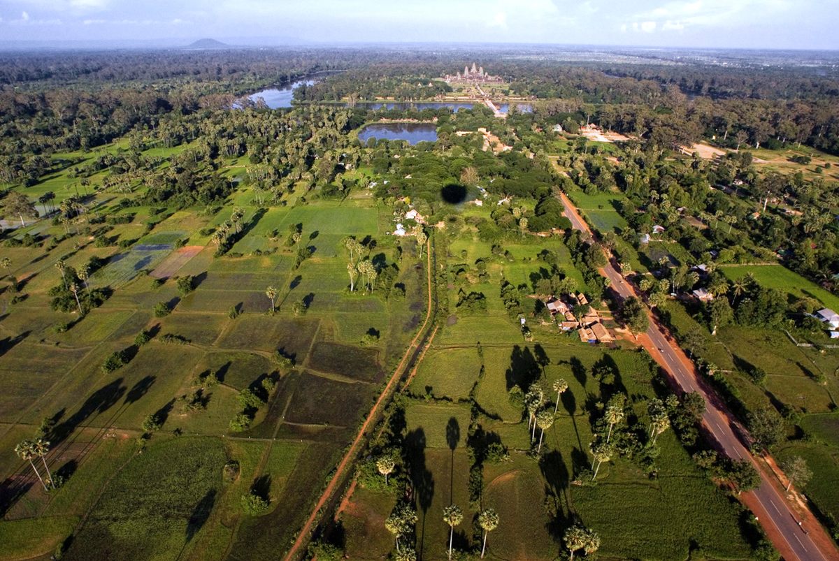
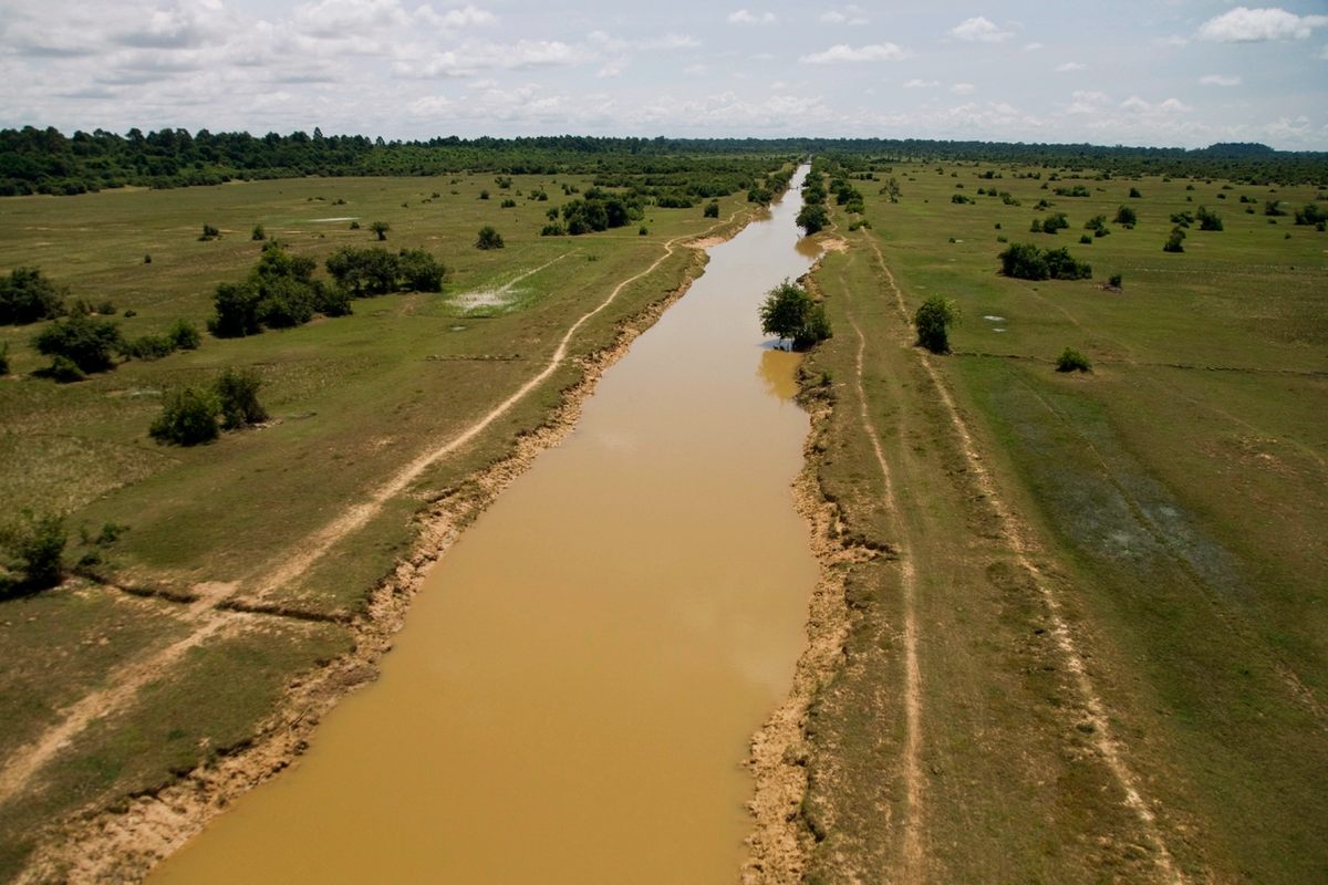
Phnom Penh is joined to Angkor by the Tonle Sap River, which winds north from the modern city before widening into the Tonle Sap Lake that provided the ancient capital’s farms with nourishing floodwaters every year. Eleven hundred years ago, Angkor was one of the biggest metropolises in the world, thronging with nearly a million residents, tourists, and pilgrims. When the 13th-century Chinese diplomat Zhou Daguan visited, he described elaborate city walls, breathtaking statues, golden palaces, and vast reservoirs with artificial islands. And yet even as Zhou fought his way through crowded streets to witness the king’s sumptuous processions, the city was pregnant with its own demise. The Khmer kings were losing their hold over the empire’s provincial capitals abroad, and neglecting the city’s crucial water infrastructure at home. Some years, Angkor’s dams burst during rainy season; other years, silt choked the canals and slowed the flow of mountain water to a trickle. And each time this happened, repairs got harder. Farming got harder. Trade slowed down, and political tensions heated up. By the mid-15th century, the city’s population had fallen from hundreds of thousands to mere hundreds.
Though obvious in retrospect, it was the kind of incremental catastrophe that nobody could recognize until it was too late. That’s what makes Angkor’s abandonment so haunting. On a day-to-day timescale, people living there wouldn’t necessarily have noticed the city’s dramatic transformation. There was no giant sign proclaiming the end of life as they’d known it; instead, there was a mounting pile of annoyances and disappointments. Nobody was fixing the canals, and the reservoirs were flooding. Some of the once-thriving neighborhoods had fallen empty and silent. There were no more fun parades on festival days. Younger generations would realize they had fewer economic opportunities than their elders had. In the 14th century, an Angkorian kid with talent might grow up to become a full-time musician or scholar at court. Or she might have a thriving business selling spices on the heavily trafficked roads to temples at Angkor Wat and Angkor Thom. But by the late 15th century, young Angkorians had few choices. Mostly they grew up to be farmers. Some became priests or monks, tending what remained of the faded temples.
In the soft apocalypse at Angkor, we can see directly what happens when political instability meets climate catastrophe. It looks chillingly similar to what cities are enduring in the contemporary world. But in the dramatic history of the Khmer culture’s coalescence and survival, we can see something equally powerful: human resilience in the face of profound hardship.
Somehow, Angkor managed to exist at a size bigger than many modern cities for hundreds of years, despite the fact that this region of Cambodia is known for its climate extremes, with rainy season floods and dry season droughts. While their kings waged wars abroad and fought internecine battles in court at home, the Khmer people razed the tropical jungle and replaced it with an orderly city grid, complete with elevated, flood-proof houses and a canal network for drinking water and irrigation. The Khmer built towns, hospitals, and bureaucracies at a rate that would have made Rome’s emperors jealous. How did this medieval civilization thrive in an environment that would be challenging for us even today?
The answer, say archaeologists, is not that the Khmer were somehow ahead of their time, nor that they were in league with ancient aliens. (Of course there are people who claim that Angkor was built by aliens. ) Instead, it was because Khmer urbanites came from a tradition of tropical city-building that looks very different from what we see in the more northerly regions of the Levant and Europe. For nearly 45,000 years, the Khmer’s ancestors were perfecting the techniques required to build and farm in the jungle, manipulating earth and water to make empires whose remains often melted back into nature, leaving very little trace.
It probably began with a forest fire. Fifty thousand years ago, humans in Southeast Asia were fanning out across the South Pacific in reed boats, eventually island-hopping all the way down to Australia. During that time, they settled in the lands that would one day belong to the Khmer Empire, as well as on islands that we know today as Indonesia, Singapore, the Philippines, and New Guinea. In all these places, bands of roving humans foraged at the edge of dense tropical jungles, living on plants and small animals. At some point, they would have noticed that forest fires had a paradoxical effect. Though initially deadly, the flames also cleared away underbrush and left a layer of charcoal behind. Some of humans’ most beloved foods, like yams and taro, flourished after the jungle had been torched—partly because they had more room to grow, but partly because those charred bits created a more nutrient-rich soil. After observing the benefits of wildfire, says Max Planck Institute archaeologist Patrick Roberts, humans figured out that they could start these fires themselves and reap the benefits.
Roberts is the author of Tropical Forests in Prehistory, History, and Modernity, a fascinating survey of how the equatorial jungles incubated civilizations that looked very different from early cities in other parts of the world, such as Çatalhöyük in what is now Turkey. In areas as far-flung as Southeast Asia and the Amazon, Roberts and his colleagues have found clear evidence that humans set off controlled burns. Sometimes they would work the soil with their hands afterward, mixing in the charcoal along with animal bones and feces to create more fertile ground. Over thousands of years, they learned how to encourage certain trees and plants to grow, scattering seeds from banana trees, sago palms, taro, and other starchy staples, and eventually changing the tree populations of the forests where they foraged. When they paddled between islands, they brought their seeds and burning techniques with them, carrying favored plants and small mammals back to Southeast Asia. From South Asia, they brought chickens down to the South Pacific Islands in boats as well. It wasn’t agriculture exactly—it was more like proto-farming. The groups doing this were probably still nomadic. But even millennia later, scientists can use stratigraphic techniques to see the ways these ancient people altered the jungle. Lower (older) layers are packed with a mix of fossilized pollen and seeds from a naturally occurring mix of plants, but upper layers are full of remains from plants that are noticeably skewed toward crops favored by humans.
While people were molding bricks to make the first houses at Çatalhöyük, people across the world in the highlands of New Guinea were digging deep trenches to drain a swamp known today as Kuk. The people of Kuk Swamp built elaborate structures to live in, and planted bananas, sugar cane, and taro in the drained farmland they’d created. Their settlement was the culmination of generations of humans working the earth. A landmark paper published by Roberts and his colleagues in 2017 in the scholarly journal Nature Plants sums up: “There is now clear evidence for the use of tropical forests by [humans] in Borneo and Melanesia by c. 45,000 years ago; in South Asia by c. 36,000 years ago; and in South America by c. 13,000 years ago.” By the time we reach the Angkorian period, people in Southeast Asia would have had plenty of experience building settlements in an extreme environment.
Roberts says this doesn’t mean tropical urbanites somehow “beat” more northerly communities in the race to build cities. “Clearly, urbanism is different in different parts of the world,” he told me. “We need to be more flexible in how we define this.” Cities aren’t made of the same materials throughout the world, nor do they have the same design. Roberts continued, “The tropics demonstrate that where we draw the lines of agriculture and urbanism can be very difficult to determine.” This has sometimes made it hard for archaeologists to identify urban remains that aren’t as recognizable as stone walls and figurines. To find early cities in Southeast Asia, scientists look for what they call “anthropogenic geomorphology.” (To break down all those Greek roots, “anthropogenic” means “human-caused” and “geomorphology” is the study of earth-shaping.) The term encompasses all the ways that humans have sculpted the land for their own uses, from planting trees and mixing fertilizer into the soil to draining swamps and building artificial hills as foundations for wooden huts.
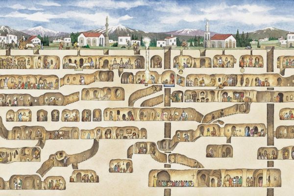
Understanding the ancient origins of anthropogenic geomorphology is key for recognizing the remains of cities like Angkor, where only a tiny fraction of the urban grid was made from stone. The cities that arose out of the long history of tropical agriculture weren’t high-density clusters of stone buildings ringed by farms like many ancient cities. Instead, they were low-density sprawl that incorporated large swatches of farmland into the urban fabric. Homes and public dwellings were made from earth and perishable plant materials. Though impressive, these urban features quickly returned to wilderness after people had abandoned them. When European archaeologists first visited Angkor, they were conditioned to look for Western modes of urban development, and thus the vast majority of homes in the city remained invisible to them. They made a beeline for the stone towers of Angkor Wat and Angkor Thom, mistaking these temple complexes for small walled cities, instead of walled compounds within a massive urban sprawl. They completely missed the once-packed neighborhoods, reservoirs, and farms that had left their marks on the land for acres around.
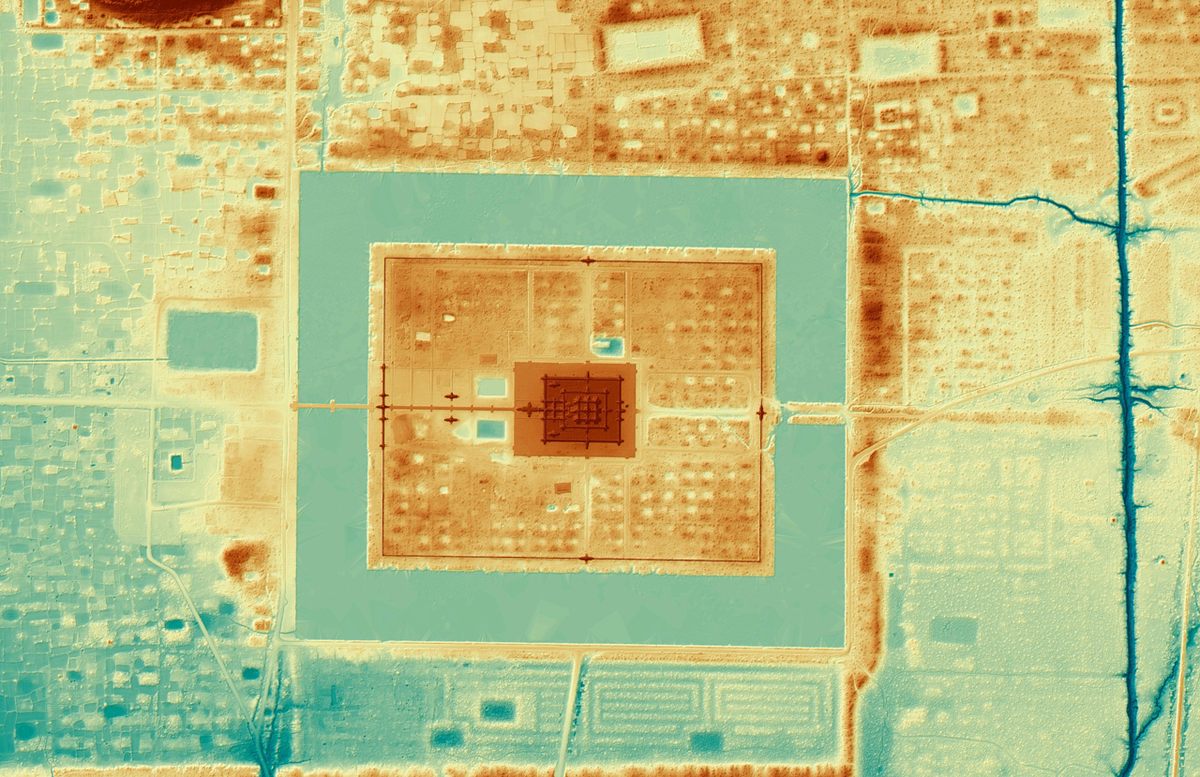
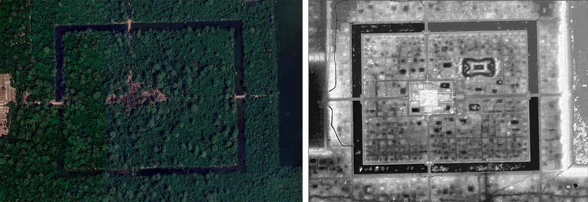
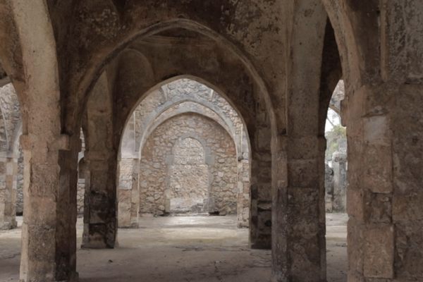
It became very obvious to me how archaeologists could make that mistake when I visited Sambor Prei Kuk, once the crowded capital city of the seventh-century Chenla Empire in Cambodia. Now all I could see were a few scattered temple towers and a 1,300-year-old wall that looked like a hill covered with underbrush. Sitting on a broad rock and looking around, I couldn’t imagine these crumbling structures as part of a metropolis. And yet Sambor Prei Kuk, with its Hindu temples and large reservoir, was in many ways the prototype for Angkor. Shaded by the trees that give this place its name—Sambor Prei Kuk is Khmer for “the temple in the richness of the forest”—I pored over maps of the area with archaeologist Damian Evans. “There was a huge wooden city here once,” Evans said, waving his arm in the direction of a small dirt road paved in fallen leaves. “Once it rotted away, what remained were moats and ramparts and mounds.” That’s what he’s got on his map, which shows the ground elevations around us in granular detail.
Evans and his colleagues created this map and many others of the Angkor region using an imaging technology called lidar, short for “light detection and ranging.” Lidar instruments scatter laser light off the planet’s surface, capturing the photons as they bounce back up. By analyzing the light pattern with specialized software, mapmakers can recreate ground elevations down to the centimeter. Lidar is ideal for studying anthropogenic geomorphology because the rain of light slips between leaves, peeling away the forest cover to reveal the city grid that once was. With funding from the National Geographic Society and European Research Council, Evans coordinated a team that conducted broad lidar surveys of Angkor in 2012 and 2015. The system may have been high tech, but it was also DIY. Their mapping rig started with a Leica ALS70 HP lidar instrument, roughly the size and heft of two portable generators. Operators mounted the lidar inside a protective plastic pod and then attached the whole rig to the right skid of a helicopter. Secured next to it was an off-the-shelf digital camera taking pictures of everything, so they could match up the lidar data with regular old photos. The system was effective, but a little awkward for passengers. “We had to rip out most of the seats in the helicopter to put in a power supply and hard drives,” Evans recalled. But the discomfort was worth it. What they found has helped rewrite the global history of cities.
Evans and his colleagues’ lidar maps resolved a longstanding mystery about Angkor and its environs. For centuries, archaeologists and historians had been perplexed by inscriptions on Angkorian temples that suggested the city’s population was close to a million people. That would make its size equal to the largest cities in the world at the time, competing with ancient Rome at its height. It seemed impossible, based on the remains they could see of Angkor Wat and Angkor Thom. How could so many people have stuffed themselves inside those walled enclosures? Nineteenth-century Western scholars were loath to believe an Asian city could achieve such stature, and later researchers were skeptical about the accuracy of inscriptions ordered by the king. It wasn’t until Evans and his team revealed the landscape in and around Angkor with lidar that it became obvious that those inscriptions were no exaggeration. Today, Evans argues that the population was likely 800,000 or 900,000, making Angkor one of the world’s biggest cities in its heyday. After demonstrating how much lidar could reveal, researchers used the technique to look at other parts of the Khmer Empire, too.
One of those places was Sambor Prei Kuk, the city that predated Angkor’s rise, where I was poring over a lidar map with Evans. I quickly discovered how disorienting it was to compare what a machine could see with lasers, and what I saw with my eyes. Around me were leafy trees and rolling hills. But on the map, I could see a late-700s urban plan: Elevation measurements revealed thousands of square and rectangular mounds that once served as the foundations for temples and houses. The rocks where we’d stopped for a lunch break were in the city center, surrounded by a near-perfect square where a now-eroded wall once stood tall, possibly edged by a moat. Depressions in the ground that I had taken for natural swales were actually the remains of deep reservoirs and canals. Peering more closely at the map, I noticed hundreds of tiny mounds like goosebumps around the temples.
“What are those?” I asked Evans, imagining some kind of specialized agricultural feature.
“Termite mounds,” he replied, pointing to a lump of earth nearby. “They love it at this elevation.”
Not everything the lidar sees is from a vanished civilization. But those termite mounds were a reminder of how powerful the technology is—it can pick out extremely small features in the landscape—and how deft the researchers are at identifying the difference between ancient structures and natural features of the modern forest. Trying to ignore the insect cities overrunning the land around us, I returned to contemplating the works of humanity. Elevated causeways led away from the temple entrances and stretched out into the Tonle Sap, forming long fingers of earth that are still visible in the shimmering water. At Sambor Prei Kuk, kings of the Chenla Empire worshipped the Hindu god Shiva, unlike the Angkorian kings who preferred Vishnu. One of the most striking temple towers here is an octagon of deep orange sandstone. A flying palace is carved into one wall, its soaring towers and balconies borne on the backs of birds. Inscriptions here and in the other temple remains testify to the glory of these Hindu kings, but very little is written after an inscription about the first Angkorian king, Jayavarman II, declaring himself a divine leader in 802. At that point, Angkor began to rise and Sambor Prei Kuk slowly emptied out.
Still, Sambor Prei Kuk remains an important place for the Khmer to this day. In one temple, we found fresh baskets of incense, paper flowers, and a golden parasol sheltering a statue of the Buddha. But the centuries-old Buddha was also a modern touch. It had been built on top of an ancient lingam shrine that symbolizes the power of the Hindu god Shiva. Linga, which are found in temples throughout the Khmer Empire, can take many forms, but most often they are square pedestals with a smooth, abstract phallus shape—the lingam—mounted straight up in the middle. A stylized moat surrounds the lingam, connected to a narrow spout that juts out from the lip of the dais. This is sometimes called the yoni. Priests would pour liquid offerings over the lingam, allowing it to run into the moat before spilling out of the spout. It was an evocation of fertility, a reenactment of the way life-giving water flows down from mountain stone. Especially for people living in the river valley, where runoff from the Kulen Mountains fed the land, this would have been a powerful image.
I considered Evans’ lidar map showing the square walls around Sambor Prei Kuk’s downtown, with the temple’s earthen features spilling out into the Tonle Sap. It looked like an enormous version of the lingam shrine. As I made my way through temples and city centers across the Angkorian Empire, I saw this pattern of squares and waterways repeated on various scales, from diminutive linga to the enormous square moats nested around Angkor Thom.
But Evans was less interested in the perfection of the city’s cosmological design than he was in the commoners’ neighborhoods that lie beyond the temple enclosure’s walls. Outside, he noted, “there is no rigid urban grid,” though the lidar map offers plenty of evidence that thousands of people lived and farmed there. Architecture historian Spiro Kostof argues that all city layouts can be grouped into two basic types: organic and grid. Organic city plans are ad hoc, with winding roads and ever-changing improvised structures like the ones at Çatalhöyük or in many medieval European cities. Then there are cities built on grids, like most Roman ones, whose growth is often regulated by a centralized government. Cities in the Angkorian tradition exhibit both patterns, often with a strict grid surrounded by organic forms. These organic Angkorian neighborhoods often belonged to people who built the city and provided food for its inhabitants. Their histories did not register on Western archaeology’s radar until Evans and his colleagues used a literal radar device to call attention to them.


Follow us on Twitter to get the latest on the world's hidden wonders.
Like us on Facebook to get the latest on the world's hidden wonders.
Follow us on Twitter Like us on Facebook