Maps of 19th-Century New York’s Worst Nuisances
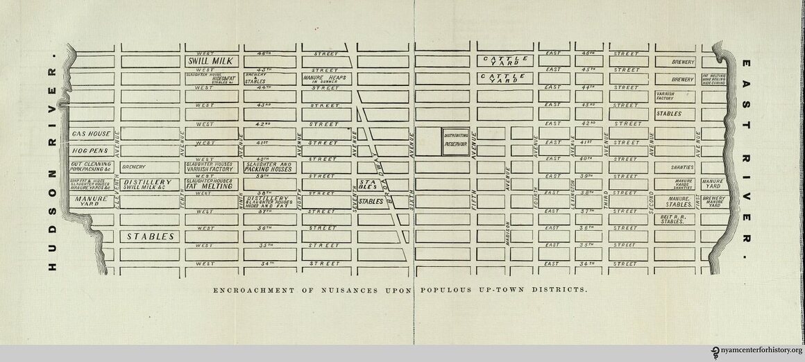
The Encroachment of Nuisances upon Populous Up-town Districts map from the 1865 Citizen’s Association Report on the Sanitary Condition of the City. (Photo: Courtesy the New York Academy of Medicine)
In 1865, the Citizen’s Association of New York published the first-ever report into sanitation and public health conditions of the city. Over a period of months, the Association had investigated “fever-nests and insalubrious quarters” across the city, to assess hygiene standards in relation to diseases such as smallpox and typhoid. Rapid population growth, overcrowded apartment buildings, dirty streets and poor sanitation standards had meant that New York in 1860 had the mortality rate of medieval London.
The report was over 300 pages long, and called for a major overhaul of the existing system of sanitation. At the time it was published, politicians actually ran the Board of Health. It was seen as corrupt and negligent in its duties: a Harper’s Weekly cartoon from April 1865 shows a Health Officer who doesn’t know the meaning of the word “hygiene.”
The money for street cleaning went straight to Tammany Hall politicians, and so New York’s streets stayed filled with manure, garbage and dead horses, which in some cases were left to rot until they had decomposed enough to be moved.
The report was unequivocal in its call for change:
We, the citizens of Lower East Manhattan, declare that this city is unsuitable for human development, child development and moral development.
We, citizens of all classes, have suffered from deadly diseases such as cholera, tuberculosis, small pox and pneumonia at the hands of public officials who scoff at our sufferings.
We believe that housing, politics, morals and health are all intertwined and without one, we would be quite at a loss.”
In addition to a detailed analysis of the sanitary conditions in each of New York City’s neighborhoods, the report also included two large maps. They located the specific “nuisances” in two city neighborhoods: what was then known as the Up-town District–the current Bryant Park area of Manhattan–and the 4th Ward, an area near today’s Financial District.
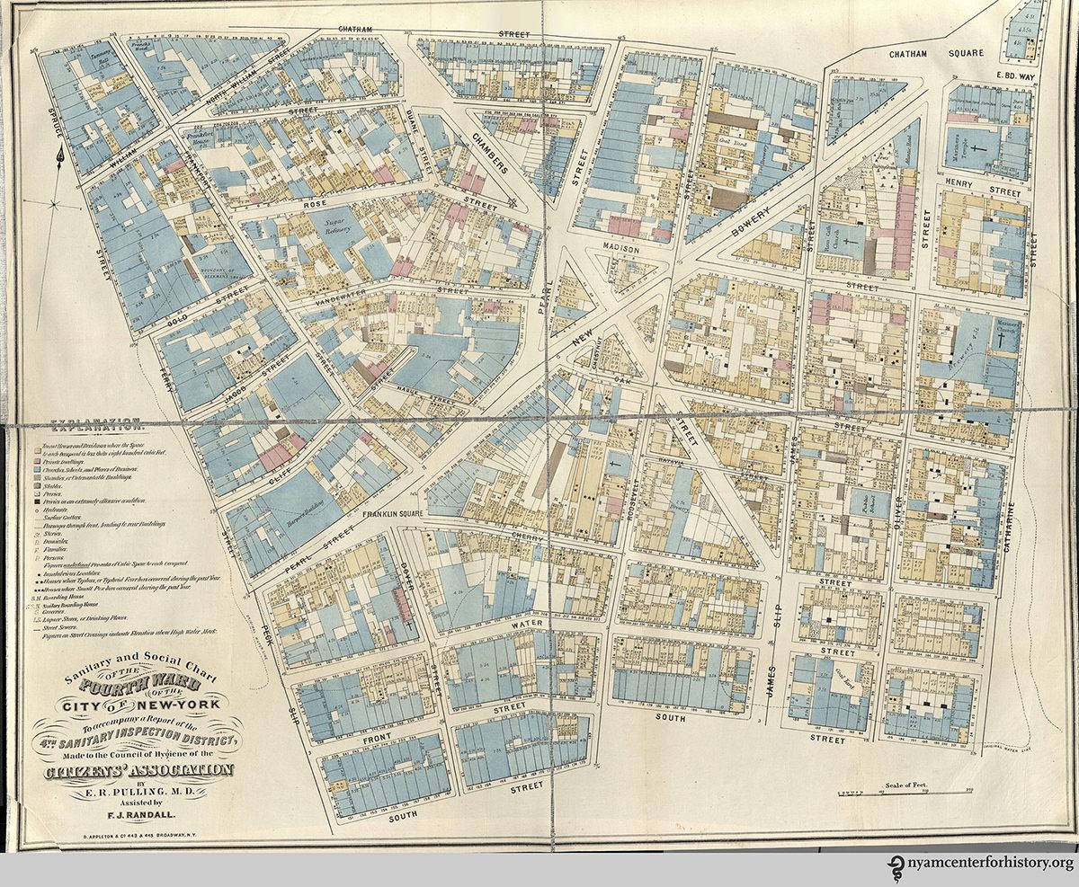
A “Sanitary and Social Chart” of New York’s 4th Ward. (Photo: Courtesy the New York Academy of Medicine)
The first map, Encroachment of Nuisances upon Populous Up-town Districts, charts fat melting and stables on the East River, and the slaughterhouses, distilleries, hog pens, gut-cleaning and pork-packing sites that dominated the West Side from Eight Avenue to the Hudson River. At the time there were 173 slaughterhouses in the city, where “a loathsome train of dependent nuisances is found grouped in the same neighborhoods.” One such “loathsome train” is found on a block of 44th Street between Seventh and Eighth Avenues: “Manure Heaps in Summer.”
The downtown map paints an even more unsettling picture of the conditions in 19th-century New York. Houses with recent cases of typhoid fever or smallpox are marked with either two or three stars. Of the conditions in the 4th Ward, the report found, “There are more than four hundred families in this district whose homes can only be reached by wading through a disgusting deposit of filthy refuse.” Liquor stores, sailors boarding houses and street sewers are all mapped out. The privies are also classified, most notably, those “in an extremely offensive condition”.
A year after the report was released, in 1866, a new law was passed to create the Metropolitan Board of Health. Under this law, at least three of the Board’s nine commissioners needed to be physicians. This marked an important move in removing public health from the control of elected officials, and it was the beginning of the reforms that led to higher sanitation standards across the whole city.
Thanks to the New York Academy of Medicine, who has copies of this landmark report, we can see these maps today in all their startling detail.
Map Monday highlights interesting and unusual cartographic pursuits from around the world and through time. Read more Map Monday posts.


Follow us on Twitter to get the latest on the world's hidden wonders.
Like us on Facebook to get the latest on the world's hidden wonders.
Follow us on Twitter Like us on Facebook