Mount Mansfield
The highest peak in the state of Vermont has some interesting features.
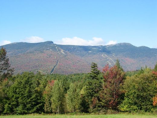
Seen from the east or west, Mount Mansfield looks like a human face laying horizontally, with peaks at the forehead, nose, lip, chin, and Adam’s apple. “The Chin” is the highest point in Vermont at 4,393 feet above sea level.
Some of the only alpine tundra in the eastern United States is along the ridgeline of Mount Mansfield. To protect this terrain, all trails are closed during the New England mud season, from mid-April to around Memorial Day. The winters see punishing snowstorms on the mountaintop and ample skiing on its slopes. Summer and autumn provide access to many different trails to the summit and vibrant colors in the surrounding forests.
The simplest way to ascend to Vermont’s highest point is to drive up the Mount Mansfield Toll Road–look for “Stowe Auto Toll Road” signs off Route 108–to the Visitors Center just underneath the nose (the Philtrum) and hike 1.3 miles along the ridgeline via the Long Trail past the lip and then to the chin. A wide view is presented, and on a clear day, you can see Lake Champlain and the Adirondack Mountains of New York.
Know Before You Go
Understand that this drive is available only in warm weather months, and the toll road to the top usually will open on 1 June, and usually will close in October. Drive up the Mount Mansfield Auto Toll Road--look for the "Stowe Auto Roll Road" signs off Route 108--to the Visitors Center and hike 1.3 miles on the Long Trail to the summit at the Chin.
Community Contributors
Added by
The Atlas Obscura Podcast is Back!


Follow us on Twitter to get the latest on the world's hidden wonders.
Like us on Facebook to get the latest on the world's hidden wonders.
Follow us on Twitter Like us on Facebook