A Map of Methane Levels Near the Massive Gas Leak in L.A.
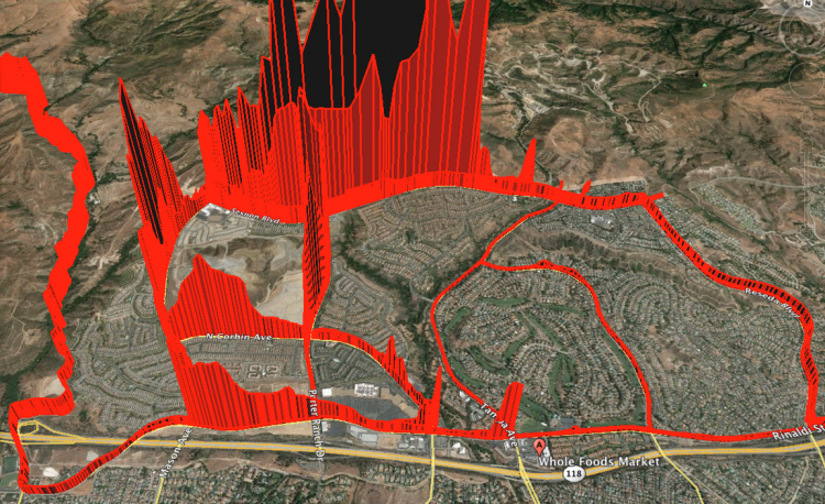
A map of Porter Ranch methane levels (Image: Rob Jackson, Nathan Phillips, and Bob Ackley)
It’s been three months since Southern California Gas Co. first reported a massive leak in its Aliso Canyon gas field, on the edge of Los Angeles, and the faulty well is still pouring methane into the air. If you look at the map above, of Porter Ranch, the neighborhood where thousands of people have been displaced, and of methane levels measured in the area, you can roughly guess where the leak is.
This map was created by Rob Jackson, a scientist at the Stanford Woods Institute for the Environment, and his colleagues Nathan Phillips, a professor at Boston University, and Bob Ackley. Recently, they took a tool they use regularly in their research–a very accurate laser-based methane detector–and spent a weekend sampling methane in Porter Ranch. The red line shows the path they drove around the neighborhood, and its height indicates the amount of methane measured.
As Jackson writes, in a post on Medium, they found a dramatic difference between the south and north parts of the neighborhood: the methane level was “an order of magnitude or more greater in the northwest corner of the neighborhood nearer the gas leak.” The gas field itself, from which the methane is spreading, is in the top-right corner of the image and behind the red wall of methane concentrations measured on the northern-most road they drove.
Jackson, Phillip and Ackley happened to have this particular sensor, a Picarro G2301 Cavity Ring-Down Spectrometer, because for the past few years, they have been working on mapping methane leaks in cities across the country. Often called natural gas, methane is commonly used in stoves and for heating, but it’s a potent greenhouse gas, which lingers in the atmosphere for less time than carbon dioxide but is many times more effective at trapping heat. (Over twenty years, for instance, methane’s global warming potential is 72 times greater than carbon dioxide.) In 2013, the researchers published a paper documenting the 3,356 methane leaks they found driving the 785 road miles in Boston; a 2014 paper reported 5,893 natural gas leaks on 1,500 road miles in D.C. More recently, they and their collaborators mapped methane leaks in Manhattan, Durham and Cincinnati, too.
The massive L.A. leak is a different beast from the accumulation of relatively small leaks they usually map, Jackson says. This one leak in Aliso Canyon, now California’s largest single source of methane emissions, has released more than 87,000 metric tons (and counting) of methane. The well won’t be sealed until February, at the earliest, according to the Los Angeles Times.
While driving around Porter Ranch, Jackson was surprised, he says, to find that sometimes it was hard to tell if the leak was happening at all. But, fifteen minute later, in the same place, if the wind changed, the air smelled strongly of gas.
Methane itself has no odor, but a smell is often added to mark its presence. The highest levels of methane that Jackson and his colleagues measured in Aliso Canyon were in the range of 25 or 50 parts per million; the greater danger to people’s health, though, is the accompanying trace gases which include benzene, a carcinogen. Still, even the odorant is enough to drive people away. “It’s very strong,” says Jackson. “I understand why people left the neighborhood.”


Follow us on Twitter to get the latest on the world's hidden wonders.
Like us on Facebook to get the latest on the world's hidden wonders.
Follow us on Twitter Like us on Facebook