I Would Walk 500 Miles, and I Would Walk 500 More, Just to Be the Man Who Walked 1,000 Miles Out on the Ocean Floor
It would be a hard 3,000 miles.
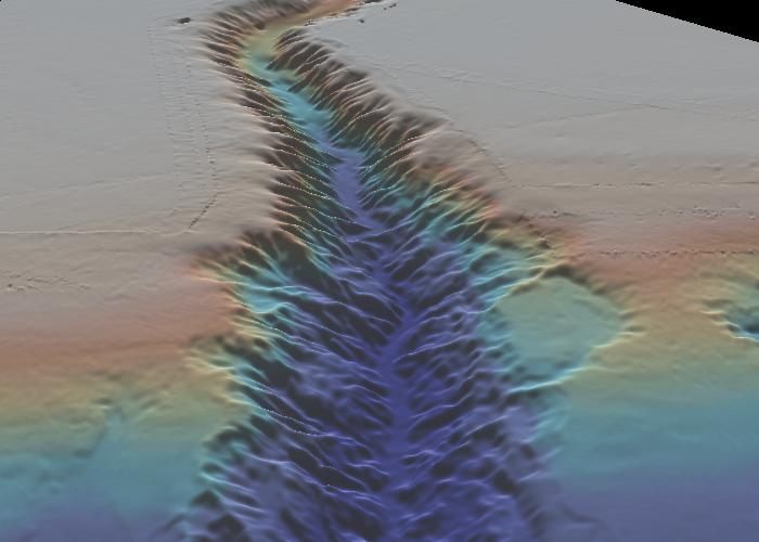
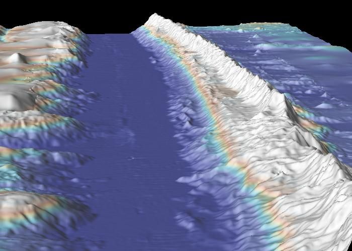
The Hudson trench, perhaps a short cut to the deep sea. (Photo: GeoMapApp/Vicki Ferrini)

Imagine this scenario. Far into the future, all of Earth’s water has dried up. (Climate change turned out to be way, way worse than we thought it would be.) The relatively little water on Mars was humanity’s only hope of long-term survival, and we moved there, joining the well-established and surprisingly successful colonies on the red planet. But, now, you’ve been sent back on a mission to bone-dry Earth.
In the Great Exodus, not everything was saved—in fact, you’re back on this planet to collect vital scientific records. But right now, the best maps you have to guide you are the ones created in the first decades of the 21st century. You’ve landed on North America, near the crumbling remains of New York City; your mission requires you to travel across what was once the Atlantic Ocean to Europe. So you take out your maps and start to plan your route.
Man, are you screwed.
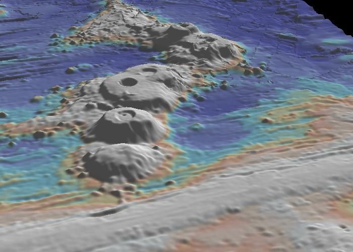
The Lamont seamounts, a much-studied set of mountains. (Photo: GeoMapApp/Vicki Ferrini)
For starters, our current picture of the seafloor is so lacking in detail that it’s often said that we have better maps of Mars. Scientists who are working to map the bottom of the world’s oceans estimate that only 10 to 15 percent has been visualized acceptably (at 100 m resolution or better), using sonar reflected off the sea bottom. To get a sense of what that means, consider that 100 m is about length of a football field and longer than a New York City block. An entire airplane could fit inside one of these squares, and you’d have no idea.
There are also spots where you’re basically traveling blind. “There are whole parts of the ocean that we have no measurements at all,” says Vicki Ferrini, who works on seafloor mapping at Columbia’s Lamont-Doherty Earth Observatory.
It used to be worse. In the past 20 years or so, ocean mappers and hydrographers have been able to use satellites to get a rough sense of ocean topography: the surface of the ocean will move up or down, in tiny increments, in response to features on the ocean floor, like a big mountain or trench, that change the gravitational traction. This, says Larry Mayer, the director of the Center for Coastal and Ocean Mapping, was a huge step forward, but even so, those maps only have a resolution of one point every 2 kilometers (about one and a quarter miles) at best.
Based on the best maps of today, Mayer says, a person planning a journey across the ocean floor could see the big ridges, some of the big seamounts, and some of the big trenches. But there could be a 1,500 meter mountain that doesn’t show up at all. Or a really big hole.
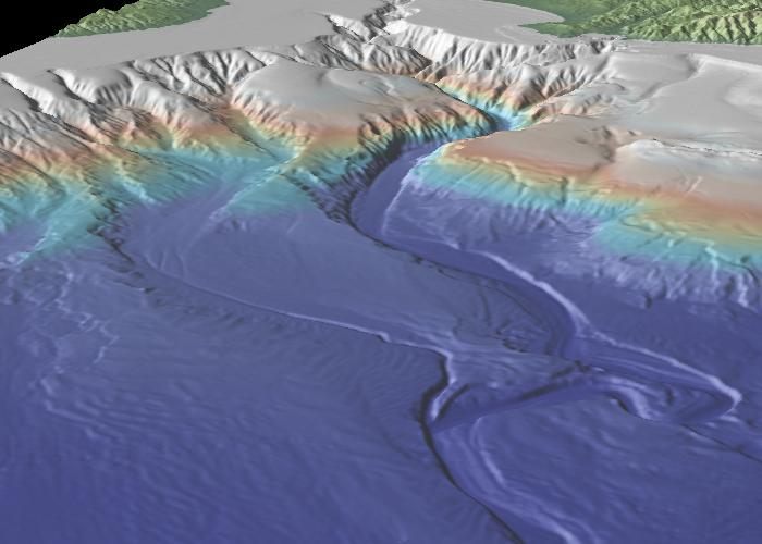
The Monterey Canyon (Photo: GeoMapApp/Vicki Ferrini)
One strategy for crossing the ocean floor would be to follow one of the large, formerly underwater cables left behind when humanity fled earth. The companies that run these ocean-crossing cables are always looking for the easiest route, which would require the cables to climb the fewest mountains. “They often miss,” says Mayer. “But we could look at where the cables go as a guide.”
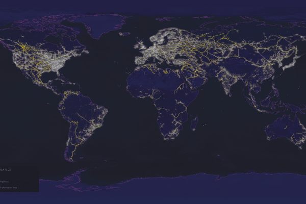
Or, you might want to stick to a route where you have at least some idea what to expect. The 100 m resolution maps often come from data gathered by ships crossing the ocean; pull that data together, and you get a scribble of ship routes. But if you followed one of those lines, at least you would have some guide as to when you might encounter a mountain.
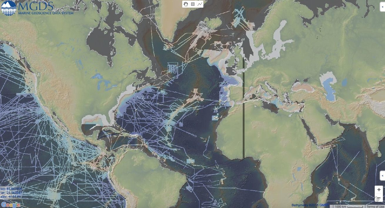
Those lines represent relatively well-mapped areas. (Image: Marine Geoscience Data System)
As you start out from North America, you’d be in pretty good shape for awhile. The East Coast of the United States has been mapped in great detail. From New York, you might choose to take a route through the Hudson Canyon, a giant valley that extends from the end of the Hudson River down into the ocean. It would be a shortcut, of sorts, into the deep sea.
Or you might walk out on the flat shelf that extends from what was once the coast line. After about 60 miles, you’d reach the continental slope, where the land would start to travel more sharply downwards, at about 2 to 3 degrees. There are canyons here, but your maps are still good enough to avoid them. At the bottom of the slope, the land flattens out again, into the abyssal plains. This is the deep sea. If the water hadn’t all dried up, you’d be under thousands of meters of water.
Traveling across the abyssal plains is where you could into trouble with the rogue mountain or valley. We know there are some big mountains off the coast of New England, which would be good to avoid. Off of Iceland, you’d hit deep sea channels, and you’d probably have to cross at least one.
Eventually, you’d reach the mid-Atlantic ridge, the place where two tectonic plates meet. On the one hand, this is a relief: there are much better maps of the ridge than anywhere else in the middle of this ocean. As of last year, an estimated 75-85 percent of the mid-ocean ridges and subduction zones have been mapped. On the other hand, you have to cross a massive mountain range, and it’s prone to earthquakes and volcanic activity, as it’s shifting at about the rate that your fingernails grow.
The Vema transform fault. (Photo: GeoMapApp/Vicki Ferrini)
Ferrini has visited the range in a submarine before the most analogous experience she’s had on land is visiting the Big Island of Hawai’i. “There’s this rolling landscape of lava that’s solidified,” she says, interrupted by spots of hot water and riotous life. The best way to cross it would be to aim for a transform fault, where the earth shifts to create a passage, of sorts, across the range. “If you look at the map, in the North Atlantic, the gradients a little more gentler there,” says Ferrini. That might be where you’d want to aim.
Once you made it across the ridge, the broad outlines of your journey would be about the same as you trudged back up towards what was once the coastline of Europe. Along the way, you’d have to circumvent more unknown mountains and valleys—if you could—or else find some way to cross them. And you’d count yourself lucky: the maps of this part of the ocean are relatively good. In the southern and Indian Oceans, the maps are even less detailed.
As you make this arduous journey across this unknown territory, though, you might be struck by this landscape. The ridge crests, seamounts and trenches that you travel over and around are dramatic—beautiful, even—and few humans have ever seen them. Some of them we didn’t even know were there.


Follow us on Twitter to get the latest on the world's hidden wonders.
Like us on Facebook to get the latest on the world's hidden wonders.
Follow us on Twitter Like us on Facebook