Trips Places Foods Stories Newsletters

Take your next trip with Atlas Obscura!

Our small-group adventures are inspired by our Atlas of the world's most fascinating places, the stories behind them, and the people who bring them to life.

Visit Adventures
Trips Highlight
A view of Brașov’s Old Town.
Romania • 12 days, 11 nights
Legends of Romania: Castles, Ruins & Culinary Delights
from
Balkans road trip
Bosnia and Herzegovina • 9 days, 8 nights
Balkans Road Trip: Serbia, Croatia & Bosnia and Herzegovina
from
View all trips
Top Destinations
Latest Places
Most Popular Places Random Place Lists Itineraries
Add a Place
Download the App
Top Destinations
View All Destinations Â»

Countries

  • Australia
  • Canada
  • China
  • France
  • Germany
  • India
  • Italy
  • Japan

Cities

  • Amsterdam
  • Barcelona
  • Beijing
  • Berlin
  • Boston
  • Budapest
  • Chicago
  • London
  • Los Angeles
  • Mexico City
  • Montreal
  • Moscow
  • New Orleans
  • New York City
  • Paris
  • Philadelphia
  • Rome
  • San Francisco
  • Seattle
  • Stockholm
  • Tokyo
  • Toronto
  • Vienna
  • Washington, D.C.
Latest Places
View All Places Â»
The Sea Water Distilling Plant.
Sea Water Distilling Plant
Contemplative paths.
Ayo Rock Formations
Parking Lot Shoeprints
Dewey Square Pylon & Bent 38
Latest Places to Eat & Drink
View All Places to Eat »
The pavlova comes crowned with jewel-like fruit.
Central Park Boathouse
The Village Tavern of Long Grove - exterior.
The Village Tavern
Hunter House Hamburgers
L’Escamoteur
Names on the bartop.
The Dive
Recent Stories
All Stories Video Podcast
Most Recent Stories
View All Stories »
Edward Payson Weston
How the 6-Day Race Became an American Spectator Obsession
Alresford Spy Toilet
This Public Bathroom in a Sleepy English Village Was an Epicenter for Cold War Espionage
Manhattan Well
The Manhattan Well: How Aaron Burr and Alexander Hamilton United to Solve a Murder Mystery
Beneath downtown Minneapolis, Schieks Cave has surprisingly warm groundwater, evidence of a subterranean heat island.
Schieks Cave Below Minneapolis Contains a Lake of Warm Sewage

No search results found for
“”

Make sure words are spelled correctly.

Try searching for a travel destination.

Places near me Random place

Popular Destinations

  • Paris
  • London
  • New York
  • Berlin
  • Rome
  • Los Angeles
Trips Places Foods Stories Newsletters
Sign In Join
Places near me Random place
All the United States Utah Green River Buckhorn Wash Pictograph Panel

Buckhorn Wash Pictograph Panel

This gallery of prehistoric red ochre art lines the wall of a scenic segment in Utah's San Rafael Swell.

Green River, Utah

Added By
zackofalltrades
Email
Been Here
Want to go
Added to list
CAPTION
The details of the pictograph panel.   Kerk/Public Domain
The Buckhorn Wash pictograph.   zackofalltrades / Atlas Obscura User
The figures painted in red ochre.   zackofalltrades / Atlas Obscura User
The Buckhorn Wash pictograph.   zackofalltrades / Atlas Obscura User
Plaques at the site.   Famartin/CC BY-SA 4.0
An example of the Fremont culture art.   Kerk/Public Domain
The figures on the panel.   zackofalltrades / Atlas Obscura User
The Buckhorn Wash pictograph.   zackofalltrades / Atlas Obscura User
A panorama of the panel.   Kerk/Public Domain
  breaingram / Atlas Obscura User
Been Here
Want to go
Added to list

About

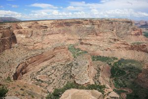
The rugged terrain of the San Rafael Swell in Utah creates a spectacular picture and even contains some pictures of its own. The Buckhorn Wash is one of its several canyons and gorges to boast a gallery of prehistoric wall art.

Buckhorn Wash is near the northwestern corner of the swell, one of the more accessible parts of the region. Its rock panels contain figures drawn in red ochre, believed to have been first created by people using the Barrier Canyon Style that flourished between 1,500 and 4,000 years ago.

This group of hunter-gatherers were nomadic and probably spent part of the year in the region. The geography rendered it difficult for travelers to safely navigate the area; therefore, some historians believe the figures were painted as part of a ritual. According to this line of thought, people created the images to pray for safety before entering a dangerous stretch of terrain and to give thanks after successfully navigating it.

Researchers have divided the figures drawn on the wall into a mixture of citizens or hominid figures, composite creatures that have characteristics of humans and animals, and spirits who have the features of humans but also show abnormalities like horns, huge eyes, or a lack of limbs. Animals like snakes, dogs, and birds are also featured.

In some cases, the original art was painted over by the Fremont people who also inhabited the swell until around 1,000 years ago. They weren’t the only ones to damage and vandalize the old artwork. The corridor was a part of the Old Spanish Trail, a trade route between New Mexico and parts of California, which led to further degradation. Local authorities partially restored the surviving images in 1996.

Related Tags

Rocks Art Nature Geology Art History History

Community Contributors

Added By

zackofalltrades

Edited By

erjeffery, Kavya Ram Mohan, breaingram

  • erjeffery
  • Kavya Ram Mohan
  • breaingram

Published

December 4, 2017

Edit this listing

Make an Edit
Add Photos
Sources
  • http://www.wikiwand.com/en/Buckhorn_Draw_Pictograph_Panel
  • https://books.google.com/books?id=CGzcBAAAQBAJ&pg=PT515&dq=Buckhorn+Wash+Pictograph+Panel&hl=en&sa=X&ved=0ahUKEwj5-4SypefXAhVOct8KHYNrCy0Q6AEIMTAC#v=onepage&q=Buckhorn%20Wash%20Pictograph%20Panel&f=false
  • https://pages.vassar.edu/realarchaeology/2017/02/26/the-buckhorn-wash-pictograph/
  • http://ilovehistory.utah.gov/people/first_peoples/fremont.html
  • http://www.gjhikes.com/2014/01/buckhorn-wash-pictograph-panel.html
  • https://www.roadtripryan.com/go/t/utah/san-rafael-swell/buckhornwash
  • https://www.outdoorproject.com/adventures/utah/special-destinations/buckhorn-wash
Buckhorn Wash Pictograph Panel
Buckhorn Draw Rd
Green River, Utah
United States
39.123528, -110.693888
Get Directions

Nearby Places

Wedge Overlook

Castle Dale, Utah

miles away

Elgin Cemetery Sentimental Statues

Green River, Utah

miles away

John Wesley Powell River History Museum

Green River, Utah

miles away

Explore the Destination Guide

Photo of Green River

Green River

Utah

Places 4

Nearby Places

Wedge Overlook

Castle Dale, Utah

miles away

Elgin Cemetery Sentimental Statues

Green River, Utah

miles away

John Wesley Powell River History Museum

Green River, Utah

miles away

Explore the Destination Guide

Photo of Green River

Green River

Utah

Places 4

Related Places

  • Ancient Indian pictographs at Fate Bell rock shelter in Seminole Canyon.

    Comstock, Texas

    Seminole Canyon

    Beauty and history abound in this remote West Texas canyon.

  • Petroglyphs visible on Haleets Rock.

    Bainbridge Island, Washington

    Haleets Rock

    Mysterious ancient petroglyphs carved on a glacial boulder at the tip of Bainbridge Island.

  • A pictograph at Bear Gulch.

    Forest Grove, Montana

    Bear Gulch Pictographs

    A scenic ravine with an astounding collection of rock art created by the Indigenous people of the Great Plains.

  • Mexican Hat

    Mexican Hat, Utah

    Mexican Hat

    This balancing rock is one of Utah's most unusual geological formations.

  • Xhamia e Larme, or the painted mosque, features panels of floral and geometric patterns.

    Tetovo, North Macedonia

    Xhamia e Larme

    Artists made this mosque into a marvel of Ottoman baroque architecture.

  • Ruggles Mine

    Grafton, New Hampshire

    Ruggles Mine

    Generations of rockhounds got their start at this beloved, historic mine.

  • Rock Art Trail

    Grapevine, Texas

    Parr Park Rock Trail

    In Parr Park, thousands of painted rocks line this walking trail.

  • The Arch

    Ajo, Arizona

    Arch Canyon Trail

    A strenuous, unofficial trail leads to spectacular views in one of America's most remote national monuments.

Aerial image of Vietnam, displaying the picturesque rice terraces, characterized by their layered, verdant fields.
Atlas Obscura Membership

Become an Atlas Obscura Member


Join our community of curious explorers.

Become a Member

Get Our Email Newsletter

Follow Us

Facebook YouTube TikTok Instagram Pinterest RSS Feed

Get the app

Download the App
Download on the Apple App Store Get it on Google Play
  • All Places
  • Latest Places
  • Most Popular
  • Places to Eat
  • Random
  • Nearby
  • Add a Place
  • Stories
  • Food & Drink
  • Itineraries
  • Lists
  • Video
  • Podcast
  • Newsletters
  • All Trips
  • Family Trip
  • Food & Drink
  • History & Culture
  • Wildlife & Nature
  • FAQ
  • Membership
  • Feedback & Ideas
  • Community Guidelines
  • Product Blog
  • Unique Gifts
  • Work With Us
  • About
  • FAQ
  • Advertise With Us
  • Advertising Guidelines
  • Privacy Policy
  • Cookie Policy
  • Terms of Use
Atlas Obscura

© 2025 Atlas Obscura. All Rights Reserved.