Trips Places Foods Stories Newsletters

Take your next trip with Atlas Obscura!

Our small-group adventures are inspired by our Atlas of the world's most fascinating places, the stories behind them, and the people who bring them to life.

Visit Adventures
Trips Highlight
Pastel de nata
Portugal • 8 days, 7 nights
Portugal: A Culinary Adventure from Porto to Lisbon
from
Italy • 9 days, 8 nights
Flavors of Italy: Roman Carbonara, Florentine Steak & Venetian Cocktails
from
View all trips
Loading...
Loading...
Loading...

No search results found for
“”

Make sure words are spelled correctly.

Try searching for a travel destination.

Places near me Random place

Popular Destinations

  • Paris
  • London
  • New York
  • Berlin
  • Rome
  • Los Angeles
Trips Places Foods Stories Newsletters
Sign In Join
Places near me Random place
All the United States New York State New York City Brooklyn Gravesend

Gravesend

Nearly four centuries after its founding, remnants of one of the oldest planned communities in North America are still visible in southern Brooklyn.

Brooklyn, New York

Added By
Anna Minster
Email
Been Here
Want to go
Added to list
CAPTION
Gravesend historical sign (though Lady Deborah was associated with Anabaptism, not Quakerism)   Anna Minster / Atlas Obscura User
Gravesend Cemetery   Anna Minster / Atlas Obscura User
Van Sicklen House, 27 Gravesend Neck Road   Anna Minster / Atlas Obscura User
Gravesend Cemetery   Anna Minster / Atlas Obscura User
1873 map of Gravesend   Beers, Comstock & Cline/Public Domain
Been Here
Want to go
Added to list

About

The village of Gravesend was founded by Lady Deborah Moody, the wealthy widow of an English baronet and an Anabaptist who fiercely opposed infant baptism. After initially settling in Massachusetts, Lady Deborah fled from the Puritan-led colony where her proselytizing wasn’t welcome, and headed for New Amsterdam, where the Dutch colonizer and director-general William Kieft, glad to have settlers, granted her a land patent. (Kieft had seized control of this land by carrying out numerous attacks on the local tribes in what became known as "Kieft's War".)

The land grant, the first in the New World to list a woman patentee, was for a vast swath of Brooklyn with access to the Atlantic Ocean. Lady Deborah laid out the 16-acre village of Gravesend with four equal quadrants centered on the intersection of Gravesend (now McDonald) Avenue and Gravesend Neck Road.

According to Thomas Campanella, a planning historian, Gravesend was the second town in the English colonies laid out according to an orthogonal plan, and the first to include a regular distribution of public open space within the grid. The open space was originally used as protected areas for animals.

The outline of the 17th-century village is most visible from an aerial view, as its orientation is slightly askew from the predominant street grid. On the ground, Village Road North, Village Road East, Village Road South, and Van Sicklen Street mark the boundaries between the original settlement and the agricultural, hunting, and fishing land outside of the fortification.

The most visible remnant of Gravesend is the cemetery in the southwest quadrant. The earliest record of the cemetery can be found in the will of Thomas Spicer, who left 20 guilders for fencing of the burial ground in 1658. The first map of the community including the cemetery dates back to 1873, found in the Atlas of Long Island, New York.

Gravesend Cemetery, now incorporating the once-independent Van Sicklen Family Cemetery, is maintained by the New York City Department of Parks and Recreation. The cemetery is gated and accessible only by prior arrangement; however, it is visible from several streets.

Ironically, the best-known Gravesend landmark is not actually a Gravesend landmark at all. The Van Sicklen House, often claimed to have been Lady Deborah’s house, is one of the oldest homes in Brooklyn—and unique in that it’s largely made of stone. It was built in the early-18th century, perhaps earlier, on a portion of a double-lot once owned by Gravesend's founder, but alas, it was never the home of Lady Moody.

Descendants of Ferdinandus Van Sicklen Jr. owned the home until the early 1900s, and realtor William E. Platt and his wife Belle acquired the house in 1904 and made extensive alterations, incorporating decorative elements inspired by the Colonial Revival Style. The Platts were responsible for popularizing the belief that the structure had been the home of Lady Deborah.

By the time the Platts purchased the house, Gravesend had ceased to be an autonomous, rural community. The Prospect Park and Coney Island Railroad opened on Gravesend Avenue in 1875. Gravesend was incorporated into the City of Brooklyn in 1894, and four years later, the cities of New York and Brooklyn merged with western Queens and Staten Island. In spite of the changes over time, the outline of the village and the 17th-century cemetery remain intact today—hidden vestiges of Lady Moody's Gravesend.

Related Tags

Cemeteries Women Religion Sacred Spaces

Know Before You Go

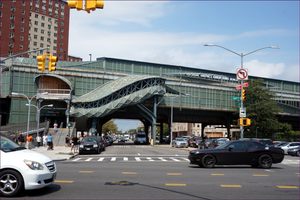
The exits to the south (toward Coney Island) from the Avenue U stop on the F subway line put you at the center of the former village of Gravesend.

Community Contributors

Added By

Anna Minster

Edited By

cjstephens

  • cjstephens

Published

July 1, 2020

Edit this listing

Make an Edit
Add Photos
Sources
  • https://www.brownstoner.com/history/moody-lady-english-roots-dutch-colony-gravesend-got-name/
  • http://s-media.nyc.gov/agencies/lpc/lp/0921.pdf
  • http://s-media.nyc.gov/agencies/lpc/lp/2145.pdf
  • https://forgotten-ny.com/2000/05/gravesend-brooklyn/#:~:text=Gravesend%2C%20located%20in%20Brooklyn%20between,was%20first%20settled%20in%201643.
  • https://en.wikipedia.org/wiki/Kieft%27s_War (calling it a genocide is inflammatory and incorrect historically]
Gravesend
Gravesend Neck Road and Van Sicklen Street
Brooklyn, New York, 11223
United States
40.594741, -73.974463
Visit Website
Get Directions

Nearby Places

'3M' Mile Marker on Ocean Parkway

Brooklyn, New York

miles away

West 8th Street - NY Aquarium Subway Station

Brooklyn, New York

miles away

Coney Island Creek

Brooklyn, New York

miles away

Explore the Destination Guide

Photo of Brooklyn

Brooklyn

New York

Places 241
Stories 46

Related Places

  • Warsaw, Poland

    Okopowa Street Jewish Cemetery

    The final resting place of more than 200,000 people, this is one of the largest cemeteries in Europe.

  • Bristol, England

    Hermit's Cave and Quaker Burial Ground

    A medieval cave used to shelter local hermits now holds nearly 200 old Quaker gravestones.

  • Prayer Hall.

    New Delhi, India

    Judah Hyam Synagogue

    This synagogue is the only place of worship for New Delhi’s small Jewish community.

  • The Tower of Joan of Arc rising over Rouen.

    Rouen, France

    Tower of Joan of Arc

    This medieval tower is all that remains of the castle where Joan of Arc was held before being burned at the stake.

  • The tombstone found at St. Paul’s Cathedral, carved in the classic Ringerike style.

    London, England

    Viking Tombstone

    This Viking gravestone carved in a rare runic style was dug up from a London churchyard.

  • Grave of Elizabeth Barrett Browning.

    Florence, Italy

    The English Cemetery

    Many famous English poets including Elizabeth Barrett Browning are laid to rest at this Swiss-owned cemetery in Florence.

  • Queen Arwa Mosque.

    Jiblah, Yemen

    Queen Arwa Mosque

    One of Yemen’s oldest and most beautiful mosques was named for the incredible, historical queen buried inside it.

  • The new church, built in 1840.

    Glynn, Northern Ireland

    St. John's Church

    Local legend says there's treasure hidden within its crowded graveyard.

Aerial image of Vietnam, displaying the picturesque rice terraces, characterized by their layered, verdant fields.
Atlas Obscura Membership

Become an Atlas Obscura Member


Join our community of curious explorers.

Become a Member

Get Our Email Newsletter

Follow Us

Facebook YouTube TikTok Instagram Pinterest RSS Feed

Get the app

Download the App
Download on the Apple App Store Get it on Google Play
  • All Places
  • Latest Places
  • Most Popular
  • Places to Eat
  • Random
  • Nearby
  • Add a Place
  • Stories
  • Food & Drink
  • Itineraries
  • Lists
  • Video
  • Podcast
  • Newsletters
  • All Trips
  • Family Trip
  • Food & Drink
  • History & Culture
  • Wildlife & Nature
  • FAQ
  • Membership
  • Feedback & Ideas
  • Community Guidelines
  • Product Blog
  • Unique Gifts
  • Work With Us
  • About
  • FAQ
  • Advertise With Us
  • Advertising Guidelines
  • Privacy Policy
  • Cookie Policy
  • Terms of Use
Atlas Obscura

© 2025 Atlas Obscura. All Rights Reserved.