About
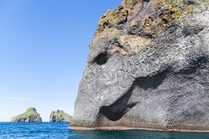
The Vestmannaeyjar, or Westman Islands, are a volcanic archipelago just off the southern coast of Iceland. At 10 square miles, the largest and only inhabited island is Heimaey, whose once-solitary volcano, Helgafell (or “Holy Mountain”) created the island in an eruption 7,000 years ago.
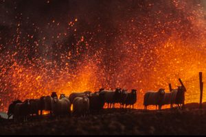
In the 1970s Heimaey boasted a population of 5,200—all of whom were abruptly awakened by Helgafell at 2 a.m. on January 23, 1973, when the volcano erupted for the first time in recorded history.
Katharine Scherman described the scene in Daughter of Fire: "They went outdoors to see a red glow through smoke over the mountain. As they watched, Helgafell appeared to explode. A fiery column burst out of its side and was thrown some 1,500 feet into the air. Burning ash rained down and the watchers ran for shelter. But their houses were no shelter. Mingled in the ash were red-hot stones, and from the east side of Helgafell a stream of lava crept toward the sea..."
Fortunately, Heimaey’s entire fishing fleet was moored in the harbor for the night, and would eventually carry everyone to the mainland. Heimaey’s only casualty in the eruption was a horse that fell into the fissure that tore the island from end to end. The force of Helgafell’s eruption added a new volcano to Heimaey’s skyline in Eldfell, or the “mountain of fire.”
While most of the lava from the first eruption flowed out to sea away from the harbor, the lava from a second eruption on January 24 crept slowly toward the town. The fishing fleet returned to evacuate a second cargo, $14 million worth of frozen fish stored at the docks. As lava engulfed the northeastern portion of the town and spilled into the harbor that enabled Heimaey’s livelihood, the islanders launched a last-ditch effort to save the town. Pumps and hoses were brought from the mainland, and seawater was pumped onto the flowing lava, eventually cooling it into a ninety-foot wall. All told, 8 million cubic yards of seawater were pumped onto the lava. Although the eastern side of the town was eventually buried under 120 feet of lava, the harbor was preserved. In total, 112 houses were burned or buried.
Heimaey’s population began to return in July 1973, and the fish processing plants at the harbor were operational a year later. Nearly a million tons of volcanic ash were removed from the town, but the island itself had grown by almost a square mile once the lava cooled. The island’s 4,000 current residents have preserved several buildings crushed by the lava in their original state, all of which can be accessed via streets that were once buried in volcanic ash. However, the most obvious evidence of the 1973 calamity is outside the town, where you can walk up the green slopes of Helgafell, the original volcano, as well as the brown, still-steaming slopes of Eldfell, the now nearly 50-year-old mountain created by the eruptions.
Related Tags
Know Before You Go
You can reach Heimaey by ferry from Landeyjahöfn, the point on the mainland closest to Heimaey. Landeyjahöfn is just under two hours by car from Reykjavik, and the ferry takes about thirty-five minutes to reach the island.
Iceland in Summer: Journey through the South Coast & the Westman Islands
Explore Iceland's Myths, Wonders, & Landscapes.
Book NowCommunity Contributors
Added By
Published
August 23, 2016
Sources
- Roberts, David. Iceland: Land of the Sagas. New York: Villard, 1990. Print.
- Scherman, Katharine. Daughter of Fire: A Portrait of Iceland. Boston: Little, Brown, 1976. Print.
- Tinniswood, Adrian. Pirates of Barbary: Corsairs, Conquests, and Captivity in the Seventeenth-Century Mediterranean. New York: Riverhead, 2010. Print.
- “Landeyjahöfn and Ferry FAQ.” Visitwestmanislands.com, visitwestmanislands.com/read/2016-04-30/landeyjahofn-faq. Accessed 10 Aug. 2016.