Five Ghost Towns Abandoned after Disasters

China’s “Ghost City” of Ordos (photograph by Darmon Richter)
The full-scale evacuation of a thriving human settlement is no small operation, yet many of the disasters preceding such evacuations are entirely our own fault. We’ve seen towns abandoned after nuclear catastrophes, such as Chernobyl and the city of Pripyat in Ukraine, or the recent Fukushima disaster and its resultant ghost town at Namie. Then there are those notorious ghost towns created as the result of war; such as the haunting, abandoned resort of Varosha on Cyprus, or ghost towns such as Bor, in war-torn Sudan.
In this article, however, we’ll be looking at five towns you might not have heard of, each of which was abandoned following a battle between humans and nature. Some of these disasters were our own fault, catastrophes provoked by overreach and greed as we dug hungrily into the earth’s crust, but others serve as a reminder that just as often, human civilization exists purely at the mercy of natural forces.
WITTENOOM
Western Australia
The first town on our list is forgotten in the deserts of Western Australia. It’s the nation’s most notorious ghost town, evacuated in the late 1970s, and widely recognized as the site of Australia’s largest industrial disaster.
Wittenoom road sign with the town’s name erased (photograph by Five Years)
From 1943 to the mine’s closure in 1966, more than 165,000 tons of asbestos were extracted and shipped out of Wittenoom. However, poor public knowledge about the dangers of asbestos allowed the toxic dust to be spread throughout the town; it clung to the miners’ clothing, infecting homes, gardens, and schools. Of the 20,000 men, women, and children who worked or lived in Wittenoom in these decades, it is predicted that roughly 25% will die of asbestos-related diseases such as asbestosis, lung cancer, or mesothelioma. It wasn’t until 1978, however, that growing health concerns would lead to a full-scale evacuation.
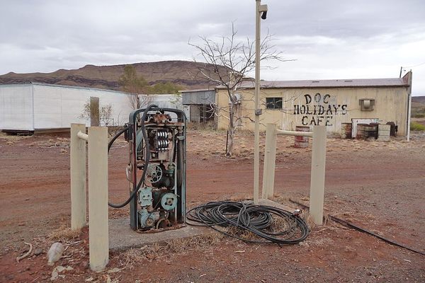
Doc Holiday’s Cafe at Wittenoom (photograph by Five Years)
Since then, the Australian government has seen fit to wipe Wittenoom off every map, more or less rendering this ghost town invisible. It lies in the vast, rocky landscape of the Pilbara region, cut off from travel routes, power grids, and other resources. In fact, every effort has been made to hide Wittenoom from the history books altogether, even erasing its name from road signs. In 2013, the Department of Local Government and Regional Development circulated a flier blaring the headline: “Visiting Wittenoom is not worth risking your life.”
Wittenoom’s Old Convent (photograph by Five Years)
While for the most part Wittenoom’s streets and houses are now at the mercy of the desert, it may not be completely abandoned yet — as of 2006, a handful of stubborn residents still remained in the town. In 2013 it was reported that the town’s gem shop was still open for business.
Wittenoom Gem Shop is still open, according to this sign (photograph by Five Years)
BEICHUAN
China
China’s “Wenchuan Earthquake” made world news in 2008 when it claimed the lives of almost 70,000 people in the Sichuan province, with a further 18,000 people listed as missing in the days that followed. The earthquake struck on May 12, registering at a scale of 8.0 Ms. It could be felt from as far away as Beijing and Shanghai in the east.
Looking out over Beichuan (photograph by Malcolm Moore)
In the wake of the earthquake, an estimated 4.8 million people were left without homes. China’s central government vowed to invest 1 trillion yuan ($146.5 billion) into the process of rebuilding, but for the time being, some of Sichuan’s largest population centers remain evacuated and in ruins.
Once such ghost town is the former city of Beichuan.
Devastation at the heart of Beichuan (photograph by David and Jessie)
Beichuan suffered extreme losses during the 2008 earthquake — notably, the collapse of two buildings at Beichuan High School that caused the deaths of more than 1,300 students. The city’s unfortunate position on the fault line also made it the victim of numerous powerful aftershocks. One of these, on August 1, 2008, registered as much as 6.1 Ms and caused even further casualties.
Close-up of the damage around Beichuan city centre (photograph by David and Jessie)
The town was completely deserted; 80% of its buildings stood destroyed or damaged beyond repair. In the years since the quake, the ghost town of Beichuan was preserved as a part of the Beichuan Earthquake Museum, and visitors traveled from across China and beyond to pay their respects to the many thousands lost in this catastrophic natural disaster. In 2013, the town was struck its final blow when a flood wrecked the region.
Prayers and offerings in Beichuan (photograph by Malcolm Moore)
GILMAN
Colorado, United States
The 19th century saw a huge property boom in Colorado, as countless plucky pioneers travelled west in search of land, gold, and freedom. Today those golden years have left the landscape littered by a legacy of crumbling homesteads, collapsed mines, and derelict mountain outposts.
Abandoned houses in the former town of Gilman, Colorado (photograph by Matthew Trump)
Some of Colorado’s oldest ghost towns have stood abandoned for more than a century; as soon as the reserves dried up, these temporary towns were left for dead as the miners moved on to the next. The mines at Gilman in Eagle Country however, remained in active use until just a few decades ago.
Eagle Mine buildings in Gilman (photograph by John Holm)
The town of Gilman is perched on the edge of a cliff, overlooking the dramatic mountain terrain of Eagle County. The mine itself is located directly beneath the settlement, and was in use as recently as 1984. That was when the entire community was finally closed down and evacuated by order of the Environmental Protection Agency.
Dramatic views in the region around Gilman, Colorado (photograph by Ryan Snyder)
On inspection of the outpost, the EPA discovered significant hazardous waste contamination. Their report cited “high levels of arsenic, cadmium, copper, lead and zinc in the soil and in surface and groundwater,” a risk so severe that it called for the full-scale evacuation of the town and the surrounding 235 acres.
The town of Gilman on April 28, 2005 (photograph by Matthew Trump)
Gilman has been on the EPA’s National Priorities List since 1986, and today the once prosperous town sits forgotten — looking out over the contaminated landscape from its perch in the Rocky Mountains.
ANI
Armenia
The lost city of Ani was once the capital of the medieval Armenian Kingdom, and between 961 and 1045 AD, it was the seat of power for all of modern-day Armenia and much of eastern Turkey.
The old city walls of Ani (photograph by Nate Robert)
Situated in a highly defensive position between the ravine of the Akhurian River to the east, and the Tsaghkadzor valley to the west, it’s easy to see why this location was chosen for a highly fortified medieval citadel.
Looking out across the Armenian countryside (photograph by Nate Robert)
Once known as the “City of 1,001 Churches,” Ani was directly on the confluence of important trade routes, making this a highly cosmopolitan — and prosperous — capital. Ani was famed for its advanced architecture, from military fortifications to elaborate churches and palaces.
The remains of an abandoned church (photograph by Nate Robert)
Ani Cathedral (photograph by Natalie Sayin)
However, disaster struck in 1319. A powerful earthquake caused untold damage to the city, toppling towers and tearing up foundations. A total population of 200,000 in the region were either lost in the quake or evacuated soon after, and as a result Ani was left largely abandoned.
The city walls of Ani (photograph by Nate Robert)
The forgotten capital, once the rival of Damascus and Constantinople, is still in ruins in the Turkish province of Kars, not far from the border with Armenia.
ARKWRIGHT
United Kingdom
Arkwright, sometimes known as “Arkwright Town,” was a settlement located in the English county of Derbyshire. The area was once a hotbed for mining and industry, and Arkwright served for many years as an industrious coal mining village.
Plaque to commemorate the former site of Arkwright Town (photograph by Peter Barr)
However, in 1988 it was discovered that emissions of methane gas from the ground beneath posed a serious health risk to the inhabitants of Arkwright, and eventually Derbyshire County Council came to the decision that the town would have to be relocated.
The now-disused Arkwright Town station (photograph by Ben Brooksbank)
Drawing up an agreement with British Coal, the ownership of the 52 properties in Arkwright Town was handed over to a housing trust, while a total of 56 new properties were constructed to the north, just outside of the area impacted by the methane emissions.
Arkwright pit wages office shortly after closure in 1988 (photograph by Dave Bevis)
The construction project was finally completed in 1995, and after the town’s residents had all been safely evacuated to New Arkwright Town, the old settlement was demolished and forgotten.
New Arkwright Town (photograph by Michael Patterson)
In 2010, a nature walk was established which follows the disused tracks of the old railway line into Arkwright. While most of the ruins have long since disappeared under a sea of grass and vegetation, visitors are still able to make out the telltale landmarks of this abandoned mining settlement. At the heart of the former town, meanwhile, a plaque commemorates the site of old Arkwright.
Discover more ghost towns left behind by disaster or other downfalls on Atlas Obscura.


Follow us on Twitter to get the latest on the world's hidden wonders.
Like us on Facebook to get the latest on the world's hidden wonders.
Follow us on Twitter Like us on Facebook