New York City’s 11 Most Accessible Ruins

Roosevelt Island Smallpox Hospital (photograph by Kimberly Wadsworth)
With space at a premium and construction at a fever pitch, ruins in New York City usually don’t last long. But sometimes an abandoned property falls through the cracks — maybe it’s a historic structure, or it’s in a remote location, or its ownership is unclear. The developer’s loss, though, is the urban explorer’s gain, and some are surprisingly easy to get access. Here are eleven of New York City’s most explorer-friendly ruins.
ROCKAWAY BEACH BRANCH RAIL LINE
Queens
Rockaway Beach Branch (photograph by Kimberly Wadsworth)
The Rockaway Beach Branch initially connected northern Brooklyn with the beaches of Rockaway, Queens. Then as subway connections increased, ridership on the line decreased, and service was cancelled in 1962. But Long Island Railroad kept the property rights, leaving the track to decay.
A three-mile stretch of the track has become a ready-made trail for Queens hikers, following the abandoned rails from Rego Park through woodsy Forest Hills down to Ozone Park. Fans have recently sparked a movement — Friends of the QueensWay — to turn the track into a reclaimed urban park much like Manhattan’s High Line.
Rockaway Beach Branch (photograph by Jim Henderson)
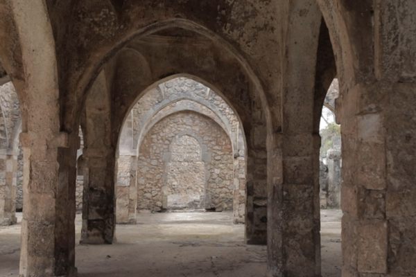
SMALLPOX HOSPITAL
Roosevelt Island
Roosevelt Island Smallpox Hospital in 2002 (photograph by Lee Semel)
Built in the 1850s on the East River’s Roosevelt Island (then Blackwell’s Island), this Gothic-inspired hospital was designed to both quarantine and treat smallpox patients, many of whom were recent immigrants. The building later became the dormitory for a nursing school on the island. When the city moved both the school and the hospital to neighboring Queens, the building was abandoned, but its striking architecture rallied preservationists to lobby against its demolition, and architect Giorgio Cavaglieri even coordinated a 1971 effort to reinforce the crumbling building in an effort to save it.
Today, the ruin is part of Roosevelt Island’s Southpoint Park, and is on the National Register of Historic Places. The interior of the abandoned hospital is inaccessible to visitors, but offers a close and striking backdrop to the newly-opened FDR Four Freedoms Park just to the south.
Roosevelt Island Smallpox Hospital (photograph by Sandi Hemmerlein)
WORLD’S FAIR PAVILION
Flushing Meadows–Corona Park, Queens
World’s Fair Pavilion (photograph by Allison Meier/Atlas Obscura)
Technically, this structure in Flushing Meadows-Corona Park was the “New York State Pavilion” during the 1964 World’s Fair. The heart of the complex designed by Philip Johnson was the “Tent of Tomorrow,” an elliptical amphitheater boasting a mosaic floor recreating the current Texaco map of New York State.
Two observation towers stood alongside, offering views of the fairgrounds from its saucer-like summits. But the pavilion’s post-fair luck was spotty. After hosting a roller rink in the 1970s, the Tent of Tomorrow was closed and the roof removed, exposing the floor to the elements. The towers were also closed. In 2014, the 50-year anniversary of the fair renewed public interest in the structures, especially after restoration advocates were permitted to give limited tours of the interior. Recently the city designated $5.8 million towards a restoration effort.
World’s Fair Pavilion Floor (photograph by Kimberly Wadsworth)
World’s Fair Pavilion (photograph by Kimberly Wadsworth)
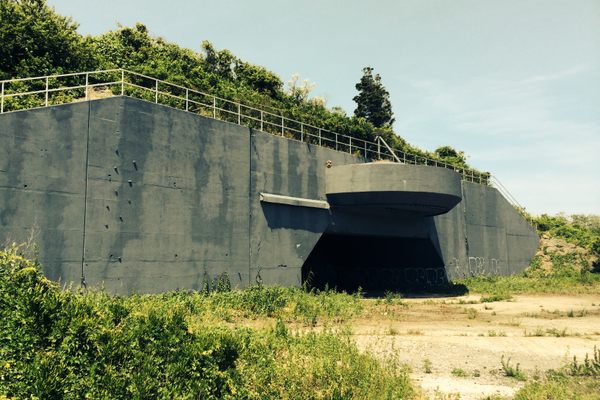
FORT TILDEN
Queens
Fort Tilden (photograph by Luke J. Spencer)
Several of New York’s accessible ruins are former forts, most situated along New York Harbor. Fort Tilden is one of the youngest, dating to 1917 when the United States entered World War I and the East Coast was considered in danger of German U-boat attacks. The site protected the Harbor using a pair of concrete batteries, each housing a pair of cannons which could fire 30 miles out to sea.
The military added anti-aircraft guns and expanded operations during World War II, then fitted the site out with Nike Ajax missiles during the Cold War. Fort Tilden was decommissioned in 1974, and became part of the Gateway National Recreation Area. Today much of the land has been reclaimed by the dunes and weeds native to the site, with the occasional remains of concrete bunkers hinting at its former purpose.
Fort Tilden (photograph by Luke J. Spencer)
Fort Tilden (photograph by Luke J. Spencer)
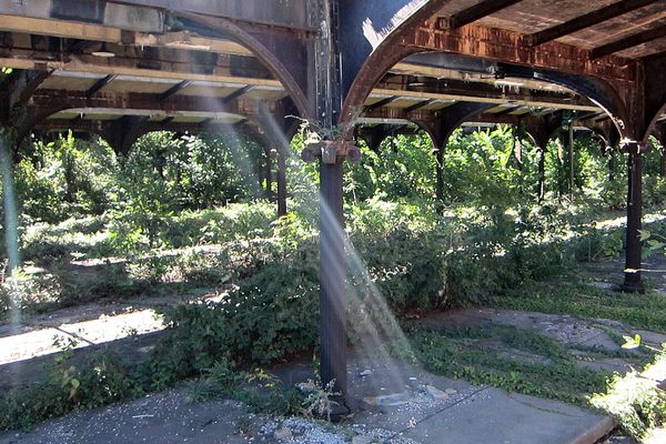
FLOYD BENNETT FIELD
Brooklyn
Hangar at Floyd Bennett Field (photograph by Allison Meier/Atlas Obscura)
Before LaGuardia and JFK, there was Floyd Bennett Field, New York’s first airport. The airfield was built during the 1930s in an effort to upstage Newark’s airport, but Floyd Bennett was actually further from Manhattan — and there weren’t many people wealthy enough to fly during the Depression.
However, professional aviators loved the site for its location and its modern facilities, and several record-breaking flights took off from Floyd Bennett, including round-the-world solo flights by Wiley Post and Howard Hughes. A 1930s folk hero known as Douglas “Wrong Way” Corrigan also took off from Floyd Bennett for a flight to California, but ended up in Ireland, claiming he’d gotten lost. The airfield briefly served as a naval flight base before joining the Gateway Recreation Area in 1972. Today, two hangars have been converted into a sports complex, while a third houses restorations of classic aircraft, and much of the rest of the field is left in a state of controlled ruin, serving hikers and boaters. There is even a campground onsite.
Inside a hangar (photograph by Missy S.)
Entrance to Floyd Bennett Field, & its very non-abandoned museum (photograph by Allison Meier/Atlas Obscura)
CENTRAL RAILROAD OF NEW JERSEY
Jersey City
Central Railroad Terminal (photograph by Allison Meier/Atlas Obscura)
While not part of New York City, the Central Railroad of New Jersey terminal played a pivotal role in connecting rail travel between New York City and the rest of the country in the 1890s. In fact, many passengers were recent immigrants from Ellis Island seeking a direct rail route to the west.
Business declined in the wake of the Great Depression and the rise of New Jersey Transit’s own rail service, and the terminal was finally shuttered in 1967, leaving the neighboring rail yard abandoned as well. The terminal reopened as a ferry station for visitors to Ellis Island and the Statue of Liberty, but damage from Hurricane Sandy has shut much of it again. The abandoned rail yard with its departure notice boards remains visible through a fence.
Central New Jersey Terminal (photograph by Allison Meier/Atlas Obscura)
Central New Jersey Terminal (photograph by Allison Meier/Atlas Obscura)
SERVICEMEN’S HOUSING
Governors Island
Governors Island Housing Block (photograph by Kimberly Wadsworth)
Governors Island has many ruins, but while historic structures like Fort Jay and the Admiral’s House enjoy revival, the ordinary servicemen’s housing has faced demolition as the city renovates this former military base. Some of the last remnants of the island’s former life stand in a plot to the southwest, filled with squat apartment buildings meant for enlisted men with families.The area will eventually be claimed by private developers, but the city won’t start hearing bids for another few years, giving the buildings a reprieve.
The buildings themselves are off limits to the public, but visitors can have a peek by visiting the Urban Farm, an educational program run by the groups Earth Matters and Grow NYC. The farm sits smack inside one cluster of apartment blocks, and has turned former playgrounds into farm beds and compost heaps, letting its chickens run free on the sidewalks.
Governors Island Urban Farm (photograph by Kimberly Wadsworth)
Chicken strutting (photograph by Kimberly Wadsworth)
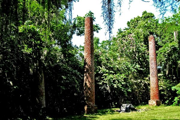
NEW YORK FARM COLONY
Staten Island
New York Farm Colony (photograph by Hannah Frishberg)
The New York Farm Colony started as a charity home. Opened in 1898, the Colony housed 200 residents who were too poor, old, or disabled to fend for themselves, putting them to work in the vegetable gardens on the property in exchange for room and board. In its heyday, the colony produced over $22,000 worth of vegetables, enough to feed not only its residents, but also thousands of others in New York’s hospitals and orphanages. After the introduction of Social Security, the colony converted to an old age facility to care for its last few residents before closing in 1975.
The Farm Colony buildings — landmarked in 1985 — have been untouched for 40 years, with rumors of Satanist and serial killers lurking on the site keeping away most visitors. Recently, developers announced plans to turn part of the site into a retirement community, restoring a handful of the buildings into residences and community centers.
New York Farm Colony (photograph by Hannah Frishberg)
FORT TOTTEN
Queens
Fort Totten (photograph by Terry Ballard)
Built to defend New York Harbor during the Civil War, Fort Totten was an active military base through the 1970s; portions of the park are still used for Army Reserve training. The rest of the grounds became a city park, including many of the Civil War-era ruins, which are free for the exploring.
New York’s Park Service gives occasional tours of the less-accessible ruins, while the former Officer’s Club building — a neo-Gothic structure nicknamed “The Castle” — is home to the Bayside Historical Society.
Old fortifications at the northwestern end of Fort Totten (photograph by Jim Henderson)
FORT WADSWORTH
Staten Island
Fort Wadsworth (photograph by Kimberly Wadsworth)
The most eye-catching ruin at Fort Wadsworth is Battery Weed, a three-story fortification built on the coast of Staten Island during the Civil War to defend New York Harbor. However, Battery Weed wasn’t completed until the war was nearly over, rendering it obsolete.
The city kept Battery Weed anyway, adding a second battlement — Fort Tompkins — on an overlooking cliff. The complex became known as Fort Wadsworth in 1864 and remained an active military base through 1995. Today, the former base is part of the Gateway National Recreation Area, with guided tours of the two forts. The New York City Marathon also uses the grounds around Fort Wadsworth as its traditional starting line each year.
Fort Wadsworth Battery Weed (photograph by Kimberly Wadsworth)
Fort Wadsworth (photograph by Kimberly Wadsworth)
CROTON AQUEDUCT
The Bronx/Manhattan/Westchester
Croton Aqueduct’s High Bridge (photograph by Sandi Hemmerlein/Avoiding Regret)
The Croton Aqueduct is an 1830s engineering marvel that provided water to an increasingly thirsty city. Using a complex network of pipes, bridges, and tunnels, and powered by gravity alone, the original aqueduct brought fresh water from the Croton River 41 miles north to a series of reservoirs throughout the city. The aqueduct had to build a bridge across the Harlem River — High Bridge — to bring the water into Manhattan. Within only 40 years, the city had grown to such an extent that another, more powerful aqueduct had to be built to keep up with demand.
In 1968, the older aqueduct was converted into a hiking trail, following the path of the underground tunnel. Most of the trail is north of New York City, in Westchester County, but hikers can follow the trail through Van Cortland Park in the Bronx before losing the historic path to New York’s streets. One of the aqueduct’s gatehouses also stands beside the trail. These buildings were spaced along the aqueduct to let workers regulate water flow and to give them access for any repair work. Three more gatehouses stand along Amsterdam Avenue in Harlem, at 113th, 119th, and 135th streets.
Croton Aqueduct Trail (photograph by Scubabear68, via Flickr)
West 119th Gatehouse (photograph by Jim Henderson)
As for High Bridge, it closed to the public in 1970, but city planners are reopening the bridge as a pedestrian and bike greenway, a former ruin accessible to all.
Croton Aqueduct High Bridge (photograph by Sandi Hemmerlein/Avoiding Regret)
Explore NYC’s Most Accessible Ruins:
ROCKAWAY BEACH BRANCH RAIL LINE, Queens
SMALLPOX HOSPITAL, Roosevelt Island
WORLD’S FAIR PAVILION, Flushing Meadows–Corona Park, Queens
FORT TILDEN, Queens
FLOYD BENNETT FIELD, Brooklyn
CENTRAL RAILROAD OF NEW JERSEY, Jersey City
SERVICEMEN’S HOUSING, Governors Island
NEW YORK FARM COLONY, Staten Island
FORT TOTTEN, Queens
FORT WADSWORTH, Staten Island
CROTON AQUEDUCT, The Bronx/Manhattan/Westchester


Follow us on Twitter to get the latest on the world's hidden wonders.
Like us on Facebook to get the latest on the world's hidden wonders.
Follow us on Twitter Like us on Facebook