About
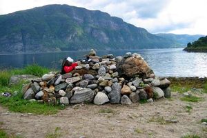
The Atlantic Road, known as Atlanterhavsveien in Norwegian, is just about the most scenic route one could imagine. The curvy road dips and arches over the brutal waves of the Norwegian Sea that often crash over the pavement during storms, and was subjected to 12 hurricanes during construction. A 5.2-mile (8,274-meter long) segment of County Road 64 in Norway, it consists of several causeways, seven bridges, and four viewpoints to take in the scenic views.
The road winds over an entire archipelago in the Norwegian Sea, linking the tiny islands and connecting the communes of Eide and Averoy in the county of Møre og Romsdal. Along with the practical reason for the road (to unify Norway) the swooping stretch is also a popular fishing spot; one of the bridges is specifically designed for it. Tourists and locals alike can go cod fishing on the designated side of the highway.
In the 20th Century, the route was originally envisioned as a railway, but the plans never managed to materialize. Schematics and planning for a road began developing in the 1970s, but construction didn't start until August 1, 1983. After being hit by one hurricane after another (for a total of 12!) and costing 122 million Norwegian Krone, the bridge was finally opened on July 7, 1989. Even though it costed a fortune, now the road is toll free.
Driving along the Atlantic Road is like teetering on the edge of the sea. The road's roller coaster-feel, curvy bridges, and phenomenal views have made it a favorite of road trippers and motorcyclists. It was also designated a Cultural Heritage Site, is considered a National Tourist Route, and has been recognized as the Norwegian Construction of the Century.
Related Tags
Community Contributors
Added By
Published
May 30, 2013