10 Places Caught Up in Odd Border Disputes
The world’s most bizarre cartographic feuds.
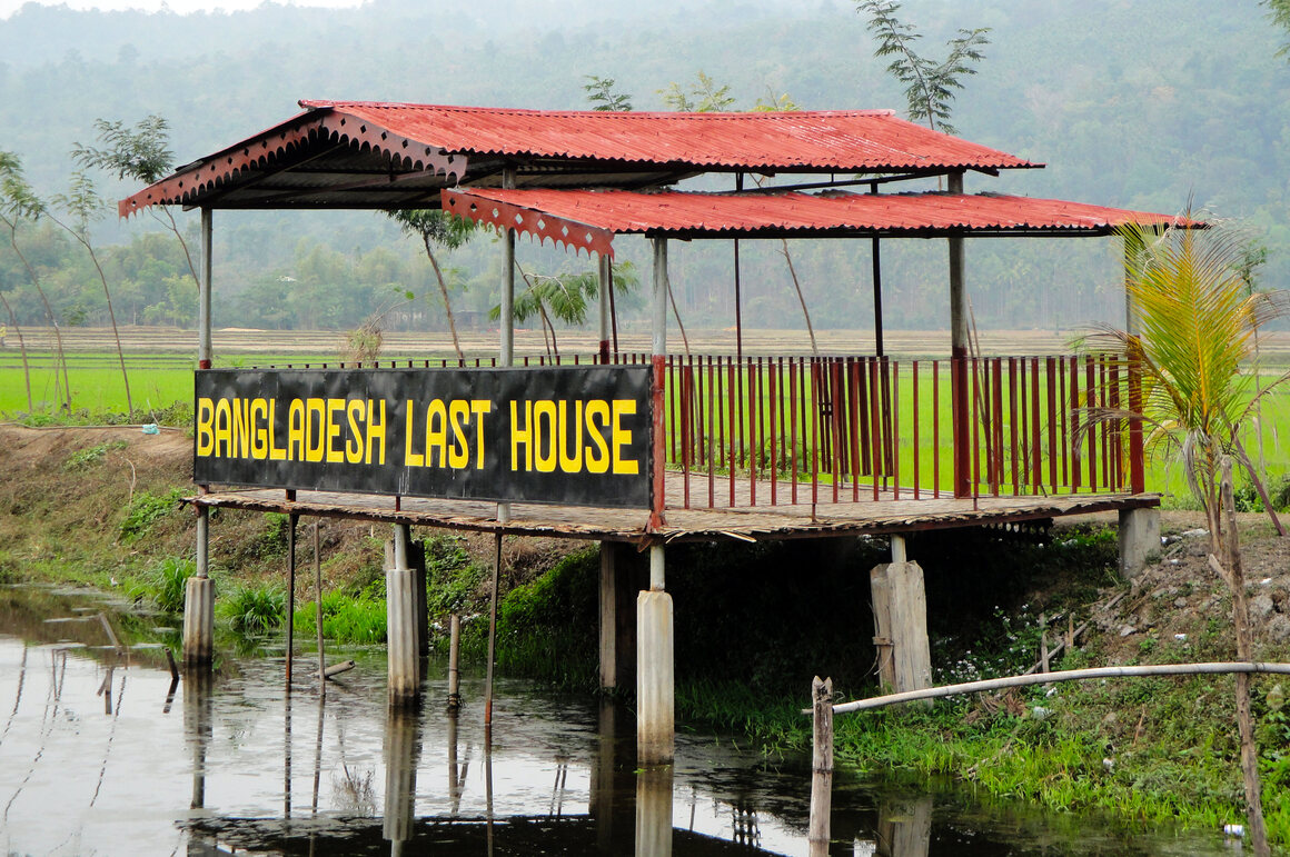
House on the notoriously disputed Bangladesh–India border. (Photo: Moheen Reeyad/CC BY-SA 4.0)

For something invisible and very often arbitrary, geographic borders have an enormous impact. In the history of the global geopolitical land-grab, innumerable wars have resulted over bits of Earth being claimed by more than one—and sometimes several—different nations.
Other times, these territory disputes result in a more unexpected situation. Bizarrely drawn boundaries have led to geographic anomalies like the tiny library that operates in two countries at once, the rare four-sided border situated at the summit of a mountain, and the jagged international boundary drawn in a puzzling zig-zag.
But sometimes a boundary, however strange, is never decided upon. Today there are about 100 disputed territories around the world, including a handful of surprisingly odd cartographic feuds. In honor of Rivals Week this week, here are 10 of the most bizarre territory disputes in the Atlas.
Marble Hill
NEW YORK, NEW YORK

The Harlem River Canal and Marble Hill. (Photo: Luke J Spencer/Atlas Obscura)
Disputed territories are very often islands, and the island of Manhattan is no exception. There is a small part of Manhattan that’s physically part of the New York’s Bronx borough to the north: the quaint neighborhood of Marble Hill. The two boroughs have been playing tug of war over this former island neighborhood for over a century.
The quarrel started with the building of the Harlem Ship Canal, which cut right through Manhattan’s northernmost neighborhood, turning Marble Hill into an island. That is until 1914, when the old creek was eventually filled in, making Marble Hill now physically part of the Bronx, but still legally part of Manhattan.
The Kuril Islands
KURIL ISLANDS

Volcano on the Kuril Islands. (Photo: Eliezg/CC BY-SA 3.0)
A world war hangs in the balance of this disputed string of volcanic islands in the Pacific—not the start of a war, but the end of one. The dispute, between Russia and Japan, has prevented the two nations from signing a peace treaty to formally end World War II. Lying equidistant between the two rival countries, this island chain is rich in natural resources, including potentially large oil and natural gas reserves under the seas.
Known in Japan as the Northern Territories and in Russia as the South Kurils, four of these islands have lain at the center of a dispute over ownership that continues to this day. While dozens of potential solutions to the conflict have been floated over the years, talks between the superpowers have led to a stalemate—which means it seems unlikely that Moscow and Tokyo will officially end the Second World War any time soon.
Preach Vihear Temple
KULEAEN, THAILAND

Preah Vihear Temple. (Photo: Khao Phra Viharn/Public Domain)
Sitting majestically atop a perilous cliff among the Dângrêk Mountains, the ninth-century Preah Vihear Temple is a gem of Cambodian temple architecture. But for a long time, many fought for this jewel to be part of Thailand’s crown.
The Dângrêk Mountains lie on the border between Cambodia and Thailand. The site’s ownership became an issue between the two countries when the temple was rediscovered in the early 20th century. Both sides wanted to own the ancient site and its rich trove of artifacts, and the dispute even went to the Hague. The international court decided that the temple belonged to Cambodia, a ruling that stands today.
Märket Lighthouse
SWEDEN

Märket Lighthouse. (Photo: Havang/CC BY 2.0)
The longstanding dispute over this quaint Nordic island began because an architect built a lighthouse on the wrong side of the island. In the late 19th century when Finnish territories were under Russian rule, Märket Island was a tiny uninhabited island divided between Finland and Sweden. It was also a treacherous piece of land, contributing to the sinking of several ships. Fed up, Russian tsar Alexander III ordered a Finnish architect to build a lighthouse on the island, which he did on the island’s highest point—which happened to be on the Swedish side of the border.
Even though the lighthouse was officially on Swedish soil, the Finns fought for it. Tensions flared between the two countries, and eventually, in 1985, they came to a mutually palatable decision: re-draw the island’s boundaries into a haphazard Z-shape to place the lighthouse on Finnish land.
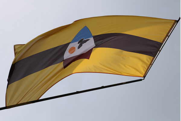
Liberland
CROATIA

(Photo: Liberland Official Facebook Page)
This self-proclaimed sovereign micro-nation is the odd result of the ongoing border dispute between Croatia and Serbia, two countries separated by the Danube River. The nature of the border dispute leaves about four square miles of current Croatian territory that Croatia believes actually belongs to Serbia. But Serbia doesn’t claim it.
The tiny patch of land was “terra nullius,” or “no man’s land,” until April 2015, when Czech political activist Vít Jedlička snatched it up and proclaimed it the “Free Republic of Liberland,” an aggressively libertarian micro-state.
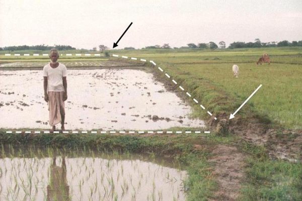
Dahala Khagrabari
PANCHAGARH, BANGLADESH

Dashed line is an international border; Bangladeshi farmer in foreground. (Photo: Brendan Whyte/Used with Permission)
Dahala Khagrabari is a geopolitical anomaly. It’s a piece of India that until very recently was completely surrounded by a piece of Bangladesh, which itself was completely surrounded by India, which was again completely surrounded by Bangladesh.
The spot is known as a third-order enclave. An enclave is a piece of one country’s territory which is entirely surrounded by another country’s territory, and the India-Bangladesh border was filled with them before a 2015 treaty eliminated most. A second-order enclave is an enclave inside an enclave, and the world has a handful of them. But Dahala Khagrabari is the only third-order enclave in the history of the world.
Three Country Cairn
FINLAND
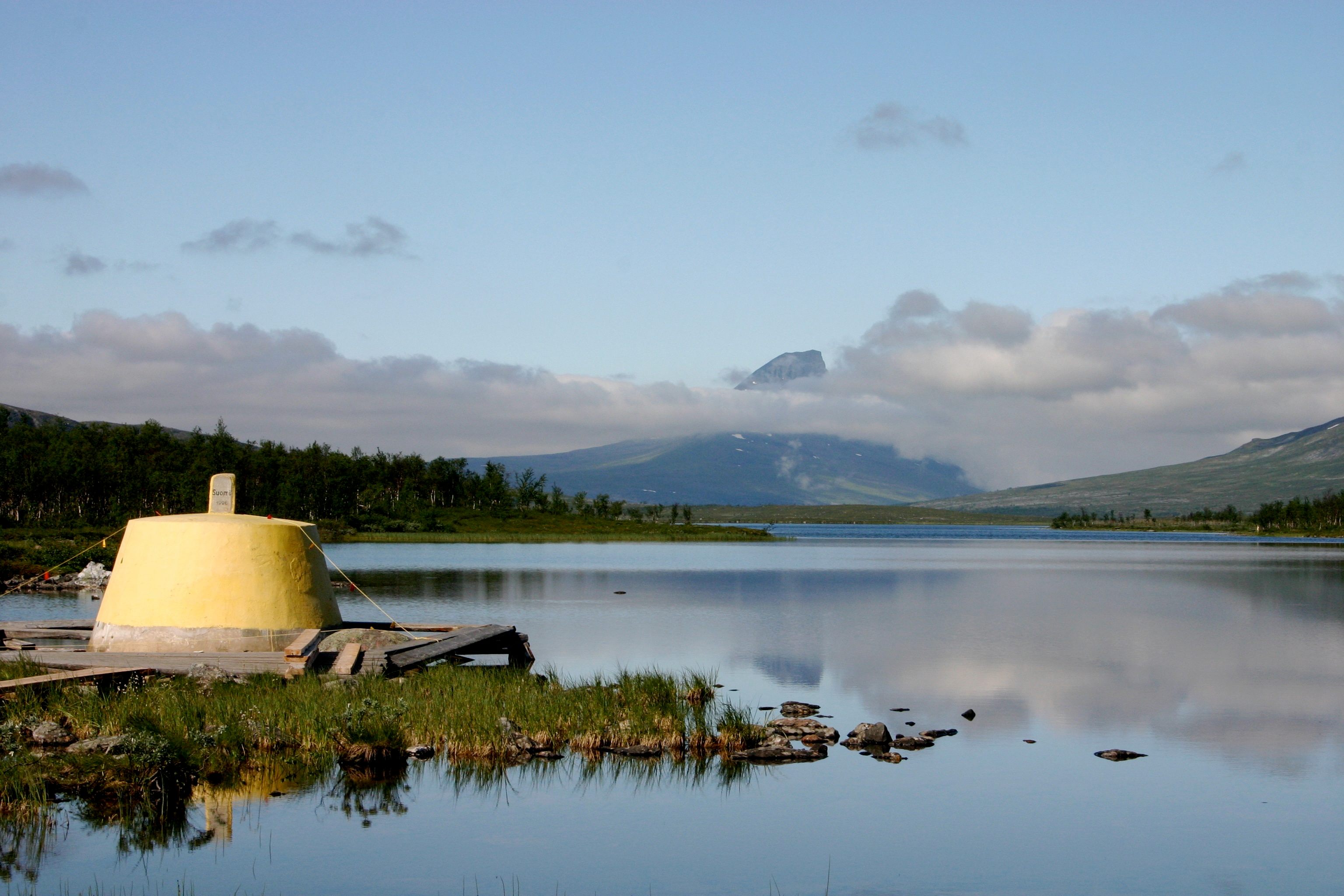
The tripoint monument from Norway, Sweden and Finland (Treriksröset) in the lake “Goldajärvi” in Lapland, Finland. (Photo: Veraldar/CC BY-SA 3.0)
Known alternately as Treriksröset in Swedish, Treriksrøysa in Norwegian, and Kolmen valtakunnan rajapyykki in Finnish, the name of this monument translates roughly to “Three-Country Cairn.” It was constructed in 1897 to settle a border dispute between the three countries. After much negotiation, the trio finally agreed on their borders and decided that the point where they all met was in the middle of a lake. Not that that stopped the construction of the stone.
Point Roberts
POINT ROBERTS, WASHINGTON

Stop. Return to Canada. (Photo: doviende/CC BY-SA 2.0)
A number of problems arose during the drafting of the 49th Parallel, the boundary between the U.S. and Canada—including the fact that Vancouver Island was split in two by the imaginary line. After some dispute, a deal was eventually made that determined the entire island would go to Canada. However, both parties failed to notice the existence of the Tsawwassen peninsula, located to the south of Vancouver proper. Once it was discovered, it was too late: the agreement had accidentally cut off a tiny piece of Canada and given it to the United States.
Today the residents of Point Roberts, an American exclave at the south end of the peninsula, must cross an international border every time they leave town.
The Spratly Islands
SPRATLY ISLANDS, SOUTH CHINA SEA

Subi Reef, Spratly Islands, South China Sea. (Photo: United States Navy/Public Domain)
Scattered over 400,000 square kilometers (154,441 square miles) of ocean, these islands might seem insignificant. By a twist of geography and international politics, however, they have managed to be at the center of a dispute between no less than six countries.
China, Taiwan, the Philippines, Vietnam, Malaysia, and Brunei have all deemed these scattered islands important enough to lay claim to them, establish a military presence on them, and even attempt colonization of them. Buy why? Unsurprisingly, oil is at heart of the conflict.
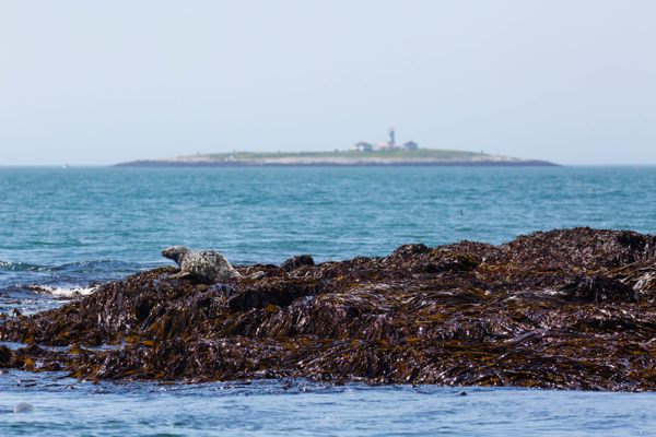
Machias Seal Island
UNITED STATES/CANADA

Seal in front, Machias Seal Island and lighthouse in back. (Photo: Melissa McMasters/CC BY 2.0)
Most Americans and Canadians are unaware that the U.S. and Canada hold five border disputes to this day. While four of these fights are over a water area (one of them due to differing interpretations of the French word “jusqu’à” in an 1825 treaty), Machias Seal Island in the Gulf of Maine is the only piece of land claimed by both of the neighboring nations. Neither country is in the mood to give it up.
The little island was never paid any attention by colonial powers until after the American Revolution, when the Treaty of Paris placed it under U.S. ownership, to the chagrin of Canada who felt it was still rightfully theirs. From the late 1700s on, Machias Seal Island was claimed by both countries. Today there is only one structure on the island, a lighthouse built in large part to secure Canada’s dibs on the island. The U.S. still has refused to recognize the lighthouse’s existence.


.jpg)
Follow us on Twitter to get the latest on the world's hidden wonders.
Like us on Facebook to get the latest on the world's hidden wonders.
Follow us on Twitter Like us on Facebook