11 Geographic Markers That Are Totally Inaccurate
These cartographic frauds are proof that mapping the globe is no simple task.


There’s something exciting about being at a special geographic spot, like the exact center of a continent or a point along an imaginary line like the equator. Throughout the globe, monuments and signs are installed to define these geographically significant locations. Only surprisingly often, these markers are actually in the wrong spot.
In some cases, the identifying plaque or signpost was simply placed at some convenient spot close to the actual point. In other cases, these cartographic frauds show just how hard it is to accurately measure the globe. The constant shift and movement of the land, along with administrative changes like labeling new regions or redrawing borders can send calculations tumbling. At the same time, our methods of measurement have evolved through the years, calculating slightly different spots with each technological advancement.
In the 20th century, many geographic center points were determined using the center-of-gravity method: The region was mapped out on a piece of cardboard, which was then cut in the shape of the outline and placed on the head of a pin to see at what point it balances perfectly. With the advent of satellite-aided and computerized mapping systems, more sophisticated methods have emerged to zero in on these centers. The result is an increasingly precise way to chart the globe. But in the process, some previous geographic markers are rendered inaccurate.
Here are 11 geographic monuments that stand tall and proud, but are not at quite the right location.

Geographic Center of South America
Cuiabá, Brazil
Back in 1909, legendary Brazilian explorer Cândido Rondon calculated the center of the South American continent—the spot with an equal area of landmass lying to both the north and south, and east and west. He determined it was in the then-remote and sparsely populated region of Cuiabá.
A modest marker and later a tall striking monument marked the spot. Later, after satellite imaging came along, a different location 28 miles away was identified as the true center. But the original obelisk still stands tall.

Europos Park
Joneikiškės, Lithuania
In the early 1990s the people of Lithuania got very excited when calculations identified a spot outside the capital city, Vilnius, as the dead center of Europe. A big sculpture park dubbed Europos Park was erected at the spot. But French scientists who had proposed the spot for the center in the first place sent news that they accidentally missed the exact target by 8 miles (14 kilometers). The correct center, which is still contested, is now marked with a square and a small museum.

The Equator Monument
North Pontianak, Indonesia
Standing a mere two miles north from the city of Pontianak is a monument constructed to represent the otherwise conceptual equator. The spot was first marked simply with an arrow on a pole in 1928 by a Dutch geographer when he visited Borneo. The first monument, originally consisting of four wooden pillars surrounding the pole, was rebuilt 10 years later and turned into a permanent monument. A globe was added to cap off the work, as well as a guard to keep it safe.
But due to constant global shift, the monument no longer lies on the exact line of the equator. In 2005, the true equatorial line was recorded a short distance south of the monument and, according to GPS readings, the line continues to move south.

Middle of the World
San Antonio de Pichincha, Ecuador
In 1936, geographer Luis Tufiño sponsored a 32-foot monument at the equator to commemorate the 200th anniversary of the French Geodesic Mission which charted the division of the hemispheres and measured the shape of the Earth. A larger monument of the same design was built on the site in 1979. The main attraction, however, is the painted line on the pavement that marks Latitude 0° 0’ 0”, where all visitors take a photo straddling both hemispheres.
Sadly, the painted line and the location of the monument are misplaced. The original calculations by Tufiño to establish the equator have been proven incorrect by more accurate modern technology and the actual line runs about 780 feet (240 meters) north of the monument. What’s more, the French Geodesic Mission it commemorates did not actually visit this site on its survey expedition.

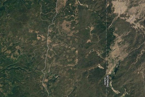
45 x 90 Geographical Marker
Athens, Wisconsin
Stuck halfway between the geographical poles, the equator, the Prime Meridian, and the 180th meridian, the point that is exactly at 45 degrees latitude, 90 degrees longitude is the center of the northern half of the western hemisphere.
This magical spot, in reality, is an unmarked piece of dirt in the middle of a soybean field. The marker commemorating “45 x 90” is some 1,063 feet away from the actual spot, and is a lot more glamorous, where gift coins are given out to visitors indicated you are a member of the 45 x 90 club.

Center of the Nation Monument
Belle Fourche, South Dakota
When Hawaii became a U.S. state in 1959, there was a need to reconfigure calculations to find the new center of the entire country. The new spot was pinpointed near Belle Fourche, South Dakota, and marked with a pole driven into the farmland.
This seemed like a somewhat weak way to honor the very middle of the United States, so the city, a little over 20 miles south of the makeshift marker, decided to do it up right. In 2008, they installed a large granite compass rose and dubbed it the “Center of the Nation” monument. There is even a metal disc in the middle that looks like an official geographic marker (though the official spot is to the north) for people to stand on and snap photos.

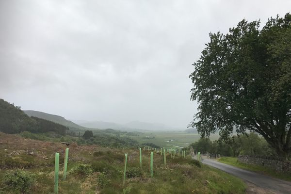
The Geographic Center of Scotland
Highland, Scotland
Scotland has not one, but three geographic centers. This mess is thanks to the use of different methods of calculation that each return different results. One center point is the midway spot between the furthest point in the North Sea and in the Atlantic Ocean. One is the center of just the Scottish mainland, and another includes the outlying islands. The people of the village of Newtonmore celebrate the first with a cross and stone marker at the spot. But the Scots living near the other two contenders would disagree.

The Geographical Center of North America
Rugby, North Dakota
Shortly after the U.S. Geological Survey determined in 1931 that a point near Rugby, North Dakota, was the center of North America, the town authorities worked quickly. The calculation put Rugby on the map, and the town seized its chance. It changed the town seal to an outline of North America, with Rugby as a dot on it. Volunteers erected a 15-foot rock obelisk in town, a proud symbol visible to those visiting or driving by.
But Rugby’s status was recently challenged by a few of the 40 residents of Robinson, a town about one hundred miles to the south. According to some calculations, neither town has the bragging rights, which instead go to a point in the town of… Center, in North Dakota.

Geographic Center of the Contiguous United States
Lebanon, Kansas
The geographic center of the contiguous United States is marked at a point about two miles northwest of Lebanon, Kansas. A small stone pyramid designates the spot measured by a survey performed in 1918. A picnic table and cozy chapel are nearby. Couples can be married at the chapel and a Bible and guestbook allow visitors to reflect and mark their attendance to the middle of America.
The problem is, the actual center determined by the 1918 survey is located on a private farm less than a mile away. And in a second plot twist, a new location was later determined in Agra, Kansas, nearly 28 miles away.

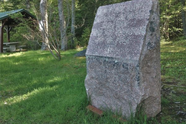
The Oldest 45th Parallel Marker in the U.S.
Perry, Maine
The 45th parallel wraps around the globe marking the halfway point between the equator and the North Pole. In the late 1880s, the United States Coast and Geodetic Survey crew were working their way northward trying to mark it, along the coast of Maine to the St. Croix River. Topographers noticed a house in Perry that just happened to fall nearly on top of the 45th parallel, missing it by the tiniest fraction of a degree (only a few tenths of a second).
The cartographers placed a brass pin next to the house to mark the spot where line crosses the main road. A few years later, the citizens of Perry decided to erect a more permanent marker, which still stands today. But the stone actually sits just a bit south of actual 45th, missing it by about 140 feet. But that took much more modern equipment to determine. The early survey crew was awfully close.

Mule Pass
Bisbee, Arizona
When the road over Mule Pass was built in 1913 and 1914, it was done by prison labor. The stubby concrete obelisk that marks the pass was placed here partly to proclaim that fact, as well as memorialize the triumph of pavement over nature.
But for some reason the marker added another claim: that Mule Pass was right on top of the Continental Divide, the invisible line separating the watersheds of the Atlantic and Pacific Oceans. That line, however, lies about 120 miles to the east, along a low rise in New Mexico.

The Real Greenwich Prime Meridian
London, England
Tourists lining up for a picture at the Greenwich Observatory Monument can save some time and go for a walk just a few hundred feet to the east in Greenwich park for a picture at the real Greenwich Prime Meridian. With the introduction of satellite based GPS navigation, the position of the Greenwich Meridian that dates back to 1851 was called into question. What modern instruments pointed out was that, due to inaccuracies in the instruments used at the time the meridian line was established, it ended up 102 meters (334 feet) west of its actual position.


Follow us on Twitter to get the latest on the world's hidden wonders.
Like us on Facebook to get the latest on the world's hidden wonders.
Follow us on Twitter Like us on Facebook