8 Scale Models That Make Nature More Manageable
The majesty of nature, scaled down.
A scale model of the mighty Mississippi on Mud Island. (Photo: Thomas R Machnitzki/CC BY 3.0)
Before computers it was difficult to map out things like geography and topography. Illustrated maps were useful but hard to translate to the physical world. Enter the scale model. Tiny terraforms and mountains in miniature allowed us to observe the natural world from an omniscient perspective.
Some of these models were made for science, some just for entertainment. In the age of satellite imaging we rarely use scale models for utilitarian purposes anymore, but they’re still out there. These little worlds help us to visualize and understand things much bigger than we are, as well as the added flattery of making us feel like giants.
The Bay Model
SAUSALITO, CALIFORNIA

The littlest Golden Gate Bridge. (Photo: Doug Letterman/CC BY 2.0)
The Bay Model was built by the Army Corps of Engineers in 1956 and ‘57 to see what would happen if the South Bay were dammed and filled in. The scale model of the Bay mimicked the tidal motion of the Pacific Ocean, and the Corps were able to prove that the results would be disastrous for the local environment. This spurred a local “Save the Bay” movement, the plan was shelved, and now the model is maintained as a museum exhibit.
Fisher Museum Forestry Dioramas
PETERSHAM, MASSACHUSETTS

Miniature foresters observe a miniature forest at the Fisher Museum. (Photo: Daderot/Public Domain)
Since 1907, Harvard University has managed 3,000 acres of woodlands in western Massachusetts that serve as the field lab and research center for the university’s graduate forestry program. In the midst of this forest is the Fisher Museum, home to a series of dioramas that tell the history of forestry itself. Twenty-three exquisitely detailed miniature dioramas portray a variety of scenes of New England forest land. Seven of the dioramas chronicle one area of the forest over a period of 300 years, from pre-colonial tree growth, to clearing for farm land, to abandonment by humans, and finally to the return of the wild, natural forest.
Hoover Dam Old Exhibit Building
BOULDER CITY, NEVADA

A tiny Grand Canyon. (Photo: Atlas Obscura user michelle)
When visiting the Hoover Dam, it’s worth stopping by the Old Exhibit Building. It’s a small room packed with old wooden theater seats arranged stadium style and directed toward a huge topographical map model of a number of southwestern states, made in the 1930s. Major cities, geological spots, and various dams and reservoirs along the Colorado are meticulously labeled, and places like the Grand Canyon or the Valley of Fire are lovingly depicted in the diorama. The overheads dim, and the map lights up. A rather dry but pleasant voiceover pipes through the speakers, and proceeds to tell about all of the places that the Hoover Dam has benefited, the map lighting up each place as it is mentioned.
The Mississippi River Basin Model
JACKSON, MISSISSIPPI

What’s left of the Mississippi River Basin Model. (Photo: courtesy of Kodachrome Guy/Used with permission)
Mississippi River floods used to displace thousands, bust through levees, and ruin farmland. Herbert Hoover called a 1927 flood “the greatest peace-time calamity in the history of the country.” The problem was that the Mississippi river was massive and the issue was being approached place-by-place in individual localities, but never addressed as a whole. What was needed was a way to see what would happen to the Mississippi given a certain set of inputs, to have some way to model the entire river system in total.
The Army Corps of Engineering (the same organization that built The Bay Model) set about constructing the largest small-scale model ever. The Mississippi River Basin model took 26 years of P.O.W. labor to build and was only used for six years, but the simulations run in it provided information that prevented major floods. The site also became a tourist destination for a time, drawing over 5,000 people a year to stride like giants along walkways above the banks of the tiny Mississippi. Once the 1970s brought about easier and more accurate computer simulations, the model was abandoned and left to decay.
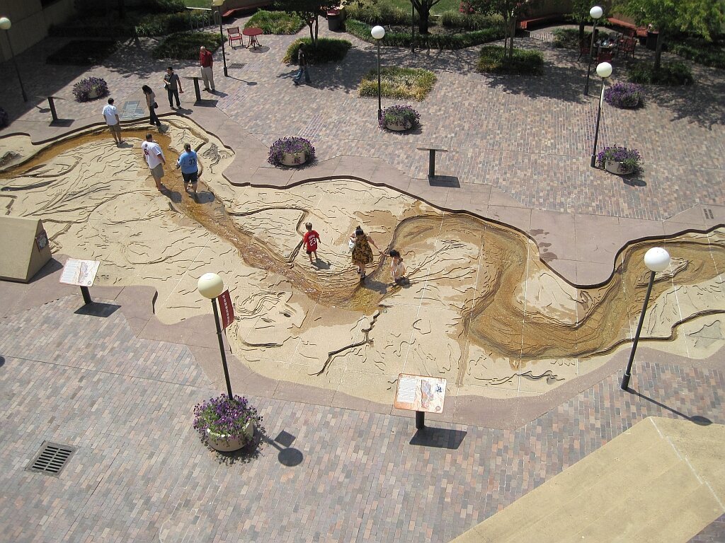
Mud Island River Park
MEMPHIS, TENNESSEE

Visitors walk along the mini-Mississippi. (Photo: Thomas R Machnitzki/CC BY 3.0)
Unlike the Mississippi River Basin Model, Memphis’ river walk exists solely for entertainment purposes. It would take you months to walk the length of the Mississippi River from Cairo, Illinois to New Orleans, but at the 5-block long replica on Mud Island you can do it in an afternoon. A 30-inch stride is equivalent to one mile on the actual river. The walk along the mini Mississippi is dotted with signs marking historical events and geographical transformations. The “1,000” mile journey concludes at the Gulf of Mexico, represented by a one-acre enclosure that holds 1.3 million gallons of water. Here, visitors can conclude their walk with a pedal boat ride around the Gulf with the Memphis skyline in the background.
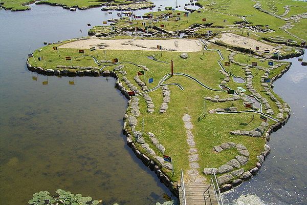
Andoke Foundation
CALI, COLOMBIA

Small-scale mountain ranges and lakes at Andoke. (Photo: Juan Velasco/CC BY-SA 4.0)
If you’ve ever wanted to see Colombia in less than an hour, this is the place to do it. In the hills above Cali is a smaller-scale, scalable map of Colombia with hanging gardens, ponds, and statues of animals. Fundación Andoke is a group of folks who designed an eco-centric educational program for kids and adults alike in order to promote and conserve Colombia’s biodiversity with regards to its natural environment, hydrography, and other natural highlights. It also features a Mariposario, where visitors can see and hold some of the butterflies native to Colombia.
Verdenskortet
HOBRO, DENMARK

North and South America at Verdenskortet. (Photo: Frank Vincentz/CC BY-SA 3.0)
Verdenskortet is the fruit of Søren Poulsen’s decades of hard work. Using a pushcart, a wheelbarrow, and various small tools, Poulson molded a peninsula on Lake Klejtrub into a to-scale map of the world. It took him over two decades, and he worked on it up until his death in 1969. The map remains a popular tourist destination. Visitors travel from far and wide to hop from Iceland to the United Kingdom, play mini golf in Antarctica, and paddle around the Pacific Ocean.
Sweden Solar System
STOCKHOLM, SWEDEN
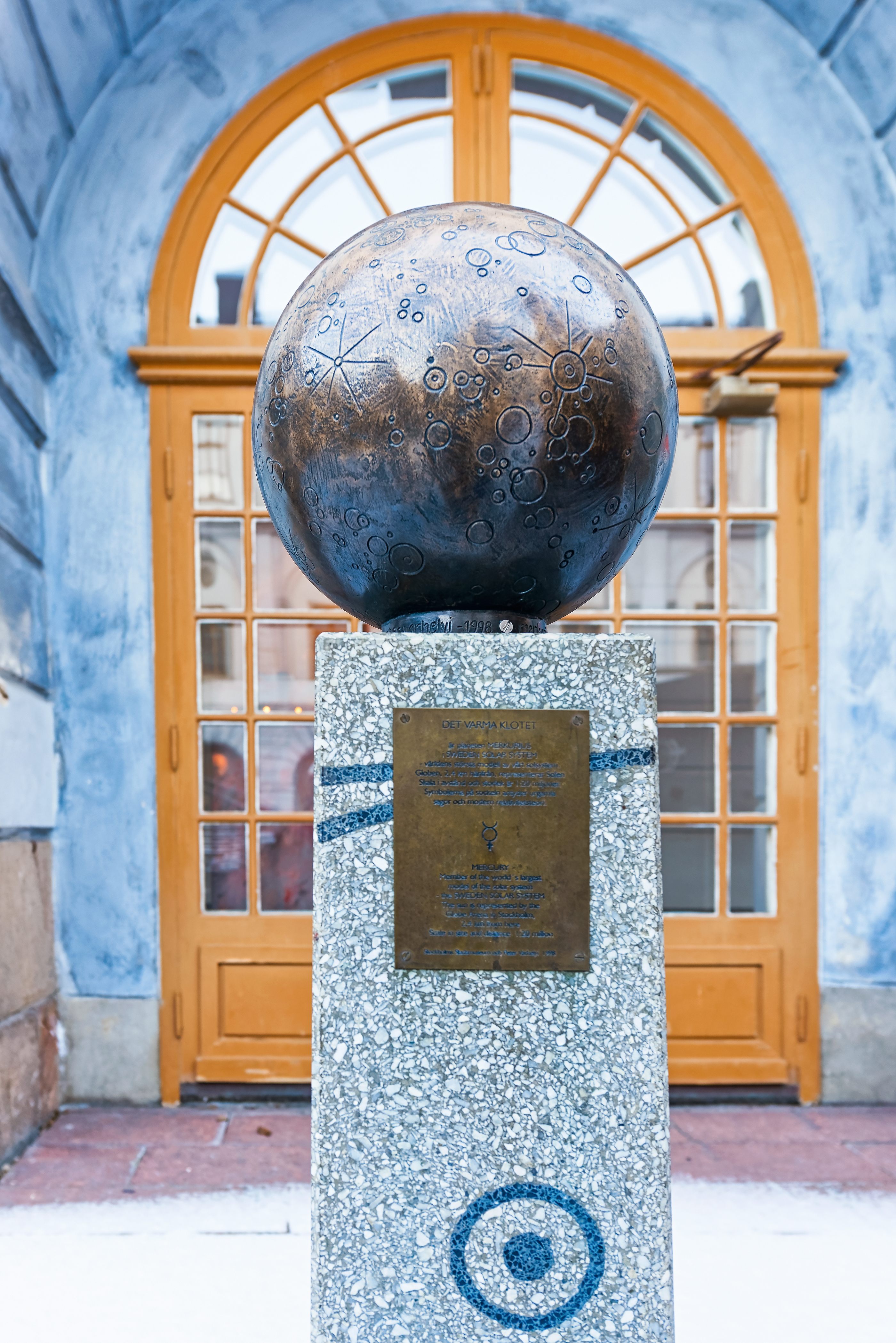
Sweden Solar System with Mercury at Stadsmuseet. (Photo: Stefan Holm / Shutterstock.com)
There are many of models of the solar system (aka “orreries”), but the largest of them is in Stockholm. Something so big as the solar system must be represented in equally grand scale, and this model uses the entire city and its suburbs as its map space. The Sun is represented by the giant dome of the Globe Arena, while Earth and its moon are at the Swedish Museum of Natural History. Jupiter is a flower bed at the Arlanda Airport and Mars lives at a mall in Danderyd. Smaller planetary objects are also represented in the model, like minor planet Sedna, or Halley’s comet, artistically depicted on a playground wall.


.jpg#/media/File:Bay_Model_(4106164471).jpg)
_-_DSC07333.JPG#/media/File:Case_13_detail_-_Hemlock-White_Pine_Forest_and_Harvard_Pond_-_Dioramas_in_the_Fisher_Museum_(Harvard_Forest)_-_DSC07333.JPG)
Follow us on Twitter to get the latest on the world's hidden wonders.
Like us on Facebook to get the latest on the world's hidden wonders.
Follow us on Twitter Like us on Facebook