Trips Places Foods Stories Newsletters

Take your next trip with Atlas Obscura!

Our small-group adventures are inspired by our Atlas of the world's most fascinating places, the stories behind them, and the people who bring them to life.

Visit Adventures
Trips Highlight
Pastel de nata
Portugal • 8 days, 7 nights
Portugal: A Culinary Adventure from Porto to Lisbon
from
Italy • 9 days, 8 nights
Flavors of Italy: Roman Carbonara, Florentine Steak & Venetian Cocktails
from
View all trips
Loading...
Loading...
Loading...

No search results found for
“”

Make sure words are spelled correctly.

Try searching for a travel destination.

Places near me Random place

Popular Destinations

  • Paris
  • London
  • New York
  • Berlin
  • Rome
  • Los Angeles
Trips Places Foods Stories Newsletters
Sign In Join
Places near me Random place
All Canada Manitoba Lorette Longitudinal Centre of Canada

Longitudinal Centre of Canada

This strangely specific landmark will let travelers know when they are half way there.

Lorette, Manitoba

Added By
Kat
Email
Been Here
Want to go
Added to list
CAPTION
  Kat/thatwritergirl
This is on the westbound side   debeachcomber / Atlas Obscura User
Been Here
Want to go
Added to list

About

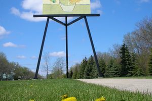
Despite being a seemingly arbitrary and meaningless fact, the exact center of Canada is actually up for debate. However, the Longitudinal Centre of Canada has been established and is marked by a uniquely specific road sign.

With signs on both sides of the Trans-Canadian Highway, anyone traveling horizontally across Canada in either direction will know exactly when they are half-way there. The sign is also presented in both English and French so that no one is left out of the cartographic fun. The exact coordinates are 96° 48' 35" as noted on the road signs and the spot was determined to be the center of the country based on the distance from its farthest outlying islands on either side. 

Related Tags

Roadside Attractions Signs

Know Before You Go

Just follow the Trans Canada Highway East of Winnipeg, Canada to coordinates 49.76773-96.8097 (49degrees 46' 02.40" 96degrees 48'35"). This point is between the two highway signs. It is approximately 8.2 miles (13.2 km) West of the junction of CA100 and CA 1 or approximately 6.7 miles (10.8 km) East of the junction of CA207 and CA 1 (near Deacons Corner, MB).

Community Contributors

Added By

thatwritergirl

Edited By

salmson2a2, nickelcurry, rhoffmore, debeachcomber...

  • salmson2a2
  • nickelcurry
  • rhoffmore
  • debeachcomber
  • TheGarv

Published

October 22, 2013

Edit this listing

Make an Edit
Add Photos
Sources
  • http://www.waymarking.com/waymarks/WM26XV
  • http://en.wikipedia.org/wiki/Centre_of_Canada
  • Google Earth
  • https://www.fcc.gov/media/radio/dms-decimal
Longitudinal Centre of Canada
99 Trans-Canada Hwy
Lorette, Manitoba, R0A 0Y0
Canada
49.770344, -96.81157
Get Directions

Nearby Places

Red River Floodway

Winnipeg, Manitoba

miles away

Riel House

Winnipeg, Manitoba

miles away

Trappist Monastery

Winnipeg, Manitoba

miles away

Explore the Destination Guide

Photo of Manitoba

Manitoba

Canada

Places 30
Stories 5

Nearby Places

Red River Floodway

Winnipeg, Manitoba

miles away

Riel House

Winnipeg, Manitoba

miles away

Trappist Monastery

Winnipeg, Manitoba

miles away

Explore the Destination Guide

Photo of Manitoba

Manitoba

Canada

Places 30
Stories 5

Related Places

  • Meadow Gold Sign

    Tulsa, Oklahoma

    Meadow Gold Sign

    This 1930s-era Route 66 Tulsa landmark was moved, restored, and filled with neon.

  • Anchorage, Alaska

    Diamond Jim's Liquor Store Sign

    A quirky roadside sign was the subject of a years-long legal standoff over highway right-of-way clearances. 

  • Nighttime looking north.

    Reno, Nevada

    Topsy the Clown

    This beloved roadside attraction welcomes visitors with his signature neon smile.

  • The Arctic Circle Sign.

    Alaska

    Arctic Circle Monument Sign

    The stickered marker pinpoints where the only maintained road in the United States crosses into the polar region.

  • Antofagasta Mountainside Messages.

    Antofagasta, Chile

    Antofagasta Mountainside Messages

    Instead of using billboards, some people here relay their messages on the side of a mountain.

  • Hatch, New Mexico

    Sparky's

    A wealth of pop culture statuary and green chile dishes give this roadside restaurant clout.

  • Plaque.

    Saint Paul, Minnesota

    School Patrol Flagpole

    This plaque marks the spot where the first crossing guards helped get kids safely to school.

  • Mileage sign totem pole.

    Stanley, Falkland Islands

    Falkland Islands Totem Pole

    Where British troops serving on the remote islands paid tribute to their faraway hometowns.

Aerial image of Vietnam, displaying the picturesque rice terraces, characterized by their layered, verdant fields.
Atlas Obscura Membership

Become an Atlas Obscura Member


Join our community of curious explorers.

Become a Member

Get Our Email Newsletter

Follow Us

Facebook YouTube TikTok Instagram Pinterest RSS Feed

Get the app

Download the App
Download on the Apple App Store Get it on Google Play
  • All Places
  • Latest Places
  • Most Popular
  • Places to Eat
  • Random
  • Nearby
  • Add a Place
  • Stories
  • Food & Drink
  • Itineraries
  • Lists
  • Video
  • Podcast
  • Newsletters
  • All Trips
  • Family Trip
  • Food & Drink
  • History & Culture
  • Wildlife & Nature
  • FAQ
  • Membership
  • Feedback & Ideas
  • Community Guidelines
  • Product Blog
  • Unique Gifts
  • Work With Us
  • About
  • FAQ
  • Advertise With Us
  • Advertising Guidelines
  • Privacy Policy
  • Cookie Policy
  • Terms of Use
Atlas Obscura

© 2025 Atlas Obscura. All Rights Reserved.