Trips Places Foods Stories Newsletters
Loading...
Loading...
Loading...
Loading...

No search results found for
“”

Make sure words are spelled correctly.

Try searching for a travel destination.

Places near me Random place

Popular Destinations

  • Paris
  • London
  • New York
  • Berlin
  • Rome
  • Los Angeles
Trips Places Foods Stories Newsletters
Sign In Join
Places near me Random place
All the United Kingdom England Devon Lynmouth Flood Memorial Hall
AO Edited

Lynmouth Flood Memorial Hall

A massive flood devastated this seaside town, causing many to speculate about whether the government had figured out how to influence the weather.

Devon, England

Added By
Michelle Cassidy
Email
Been Here
Want to go
Added to list
CAPTION
The flood swept through town, killing several people and destroying buildings and bridges.   Getty / PA Images
Lynmouth Flood Memorial Hall   Tom Bastin/CC BY 2.0
A model of pre-flood Lynmouth in 1952   Tim Sheerman-Chase/CC BY 2.0
Lynmouth after the flood in 1952   Getty / Bert Hardy / Stringer
Some of the devastation caused by the Lynmouth Flood   Getty / Reg Speller / Stringer
On the 50th anniversary of the flood, white doves were released to symbolize the victims   Getty / Chris Ison - PA Images
  Geof Sheppard/CC BY-SA 3.0
Been Here
Want to go
Added to list

About

On the night of August 15, 1952, disaster struck the village of Lynmouth in north Devon. Swollen by days of heavy rainfall, the East and West Lyn rivers burst through their walls, sending a torrential flood hurdling through the seaside town. The fast-moving floodwaters carried hundreds of thousands of pounds of rocks and other debris, which carved a path of destruction through the river valley. Overnight, 34 people were killed, more than 100 buildings were destroyed or seriously damaged, and 28 of the town's 31 bridges were swept away. 

The flood turned Lynmouth upside down. Once the waters subsided, they surveyed the damage: more than 400 people were newly homeless and nearly all of the buildings needed to be repaired or rebuilt. In addition to these immediate needs, the recovery plan included changes that would prevent a future flood from causing  the same kind of damage. The Lyn rivers were made deeper and wider and a floodplain was created and barriers were built in the lower part of the village.

Along with rebuilding, people started looking for answers. North Devon had seen 250 times more rainfall than a typical August, and survivors told stories of how the air smelled of sulphur on the afternoon of the floods. A conspiracy theory spread that these heavy rains were unnatural, and caused by cloud seeding experiments carried out by the Royal Air Force known as "Operation Cumulus." The Ministry of Defence denied these theories, but to this day, many remain unconvinced.

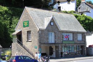
It took nearly six years for Lynmouth to fully recover from the damaged caused by the flood. To mark the completion of the reconstruction work in July 1958, the Lynmouth Flood Memorial Hall opened on the site of the former lifeboat station. Inside the small building, visitors can learn about the history of the village and the powerful flood that changed it forever. There are photographs on display, along with a scale model of the village as it was before the flood.

The Atlas Obscura Podcast is a short, daily celebration of all the world's strange and wondrous places. Check out this episode about Lynmouth Flood Memorial Hall.

Related Tags

Floods Memorials Conspiracy Theories

Community Contributors

Added By

Michelle Cassidy

Published

March 26, 2021

Edit this listing

Make an Edit
Add Photos
Sources
  • https://www.lynmouthflood.co.uk/
  • https://visitlyntonandlynmouth.com/visit/lynmouth-flood-memorial-hall/
  • https://en.wikipedia.org/wiki/Lynmouth_Flood
  • http://news.bbc.co.uk/2/hi/uk_news/1516880.stm
  • http://www.bbc.co.uk/devon/news_features/2002/lynmouth_flood.shtml
Lynmouth Flood Memorial Hall
Lynmouth St
Lynmouth
Devon, England, EX35 6EL
United Kingdom
51.230933, -3.831212
Visit Website
Get Directions

Nearby Places

'Verity'

Devon, England

miles away

Tarr Steps

Somerset, England

miles away

Merthyr Mawr Sand Dunes

Ogmore-by-Sea, Wales

miles away

Explore the Destination Guide

Photo of Devon

Devon

England

Places 14
Stories 2

Nearby Places

'Verity'

Devon, England

miles away

Tarr Steps

Somerset, England

miles away

Merthyr Mawr Sand Dunes

Ogmore-by-Sea, Wales

miles away

Explore the Destination Guide

Photo of Devon

Devon

England

Places 14
Stories 2

Related Stories and Lists

Lynmouth Flood Memorial Hall

Podcast

By The Podcast Team

Related Places

  • The 10-foot-tall monument.

    Galveston, Texas

    1900 Storm Memorial

    This memorial and the seawall that it stands near are powerful symbols of the island’s resilience.

  • Willie MacRae Memorial.

    Greenfield, Scotland

    Willie MacRae Memorial

    The solitary cairn marks a mysterious death that's still controversial more than two decades later.

  • Memorial.

    South Yorkshire, England

    Dale Dyke Dam Marker and Memorials

    The collapse of the brand-new dam caused one of the worst floods in British history.

  •  The breach in the dam wall.

    Dolgarrog, Wales

    Remains of the Dolgarrog Dam Disaster

    The worst flood disaster in Welsh history might have been a lot worse if it had not happened on movie night.

  • The tsunami stone of Aneyoshi Village

    Kesennuma, Japan

    Tsunami Stones

    Stone slabs along the coast warn of Japan's tsunami-ravaged past, often marking the highest point of a wave's reach.

  • A close-up view of the marker.

    Hartford, Connecticut

    Flood 1936 Marker

    A tiny memorial for the year the Connecticut River almost destroyed New England.

  • The Tsunami Memorial

    Hambantota, Sri Lanka

    Tsunami Memorial at Yala National Park

    Only the foundation remains of the rest stop building that was hit by three large tsunami waves, killing 47 visitors.

  • Washington, D.C.

    Signers’ Memorial

    Engraved in stone on a little Island are the signatures of everyone who signed the Declaration of Independence.

Aerial image of Vietnam, displaying the picturesque rice terraces, characterized by their layered, verdant fields.
Atlas Obscura Membership

Become an Atlas Obscura Member


Join our community of curious explorers.

Become a Member

Get Our Email Newsletter

Follow Us

Facebook YouTube TikTok Instagram Pinterest RSS Feed

Get the app

Download the App
Download on the Apple App Store Get it on Google Play
  • All Places
  • Latest Places
  • Most Popular
  • Places to Eat
  • Random
  • Nearby
  • Add a Place
  • Stories
  • Food & Drink
  • Itineraries
  • Lists
  • Video
  • Podcast
  • Newsletters
  • All Trips
  • Family Trip
  • Food & Drink
  • History & Culture
  • Wildlife & Nature
  • FAQ
  • Membership
  • Feedback & Ideas
  • Community Guidelines
  • Product Blog
  • Unique Gifts
  • Work With Us
  • About
  • FAQ
  • Advertise With Us
  • Advertising Guidelines
  • Privacy Policy
  • Cookie Policy
  • Terms of Use
Atlas Obscura

© 2025 Atlas Obscura. All Rights Reserved.