About
Before the last ice age, Lake Makgadikgadi covered a large area in what is now northern Botswana. Fed by the Nata and Boteti rivers, this lake had no natural outflow. As a result, salts gradually built up in low-lying areas. Then, nearly 10,000 years ago, the climate in southern Africa changed significantly, and the lake dried up, leaving behind a series of salt pans covering over almost 10,000 square miles, making the Makgadikgadi pans arguably the largest network of salt flats in the world.
The pans are vast, desolate, and inhospitable. Still, life persists. They are one of two breeding spots for flamingos in southern Africa, and summer rains briefly flood the pan and bring a variety of wildlife to the previously lifeless plain. While the pans are a "salty desert," where only certain types of algae can be found, there are grasslands and shrubbery surrounding the area. Archaeological evidence suggests that early homo sapiens may have even resided in the area for a while, although it is hard to imagine how, or if, they thrived there.
The pans also served as a major obstacle to missionaries pushing north in Africa. Still, despite the interactions different people have had with the pans, the Makgadikgadi salt flats remain relatively undisturbed. The salt pans are very inhospitable, and so human interaction has been minimal in comparison to other natural salt sources across the world.
There are threats to the pan though. In 1991, commercial operations to extract salt began, and there were plans made to divert water from the Nata River for irrigation, something that would cause a severe threat to the small and unusual (but not unimportant!) ecosystem.
Related Tags
Know Before You Go
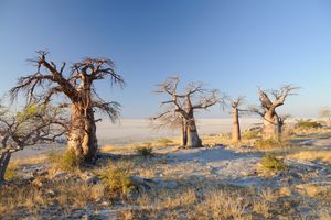
The pans are located in Makgadikgadi National Park and Nxai Pan National Park, both immediately off the A3 from Francistown to Maun. The pans are most commonly visited from the village of Gweta, but can also be accessed from Nata or the town of Maun. Tours are widely available from all three locations, but a self-drive with a 4x4 is easy. Baines Baobabs can be accessed from the gate of Nxai National Park, and Chapmans Baobabs are 20 kilometers in on the Gweta-Orapa track. Note that if you venture off the main road in the pans, death is a distinct possibility. The vast, unchanging landscape has trapped visitors before. Be familiar with off-roading and navigation if you attempt this by yourself.
Published
July 10, 2017