About
A roughly chest-high block of granite marks the site of the only atomic bomb tests on U.S. soil east of the Rocky Mountains. The tests, which were part of Project Dribble and dubbed “Salmon” and “Sterling,” were aimed at finding out whether a country could muffle the shock wave from a nuclear explosion by setting it off in an underground cavern.
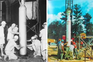
The U.S. Atomic Energy Commission picked Baxterville, fewer than 100 miles northeast of New Orleans because it sits atop the Tatum Salt Dome, a large underground salt dome. The 5.3-kiloton Salmon explosion in October 1964 carved a cavity out of that salt 2,700 feet underground. The bomb was about a third the size of the one dropped on Hiroshima in 1945.
The 0.38-kiloton Sterling test in December 1966 was set off inside that cavity to test the theory, which came out of efforts to limit Cold War-era nuclear testing. The results showed the technique couldn’t completely conceal a bomb test from the sensors set up by arms control treaties.
In 2010, the U.S. government transferred the land to the state of Mississippi, which uses it as a state timber preserve. The marker and the plaque are the only standing evidence of the clandestine nuclear operation.
Related Tags
Know Before You Go
The site is about two and a half miles down a dirt road, and access is by appointment only.
Published
August 14, 2018