An Illustrated Guide to Space Maps
Thousands of years of attempts to understand our place in the cosmos.
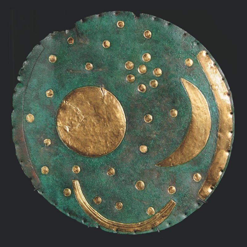
With its patinated bronze background and shiny gold sun, moon and stars, the 3600-year-old Nebra Sky Disc is worth gazing at for its beauty alone. But the ancient object is cool for a lot of other reasons: It’s the earliest depiction of outer space we’ve ever found, and it’s also thought to be the oldest known portable astronomical instrument.
For as long as humans have stared at the sky, we have sought to understand our place in the cosmos. This lovely orb is one of a long line of attempts of humans to map the unmappable—space. Scientists posit that the Bronze Agers who made the disc used it as an “astronomical clock” to correct for the shortcomings of moon-based calendars. Because the moon goes through twelve cycles every 354 days, not every 365, early agriculturalists had to throw in an extra leap month every once in a while to keep lunar calendars in sync with earthly seasons. They knew to add the extra month when the moon and the Pleiades were arranged “exactly as they appear on the Nebra sky disc.”
The story behind the disc’s discovery is almost as crazy as the disc itself: it was dug up by metal-detector- wielding treasure hunters in 1999, along with “two swords, two axes, a chisel, and fragments of armlets.” The looters sold the lot, and it made the rounds on the black market until someone tried to fence it to a Swiss “antique collector” who turned out to be a police officer pulling a sting. They were arrested, and the state claimed the disc, which has since been declared an official UNESCO “Memory of the World” object.
Is it art or science? Hard to say. Below is our roundup of the most marvelous attempts at mapping space, from 1600 B.C. to the hyper-precise satellite depictions of the modern era.

Compiled by the Dutch astronomer and mathematician Andreas Cellarius towards the end of his life, the Harmonia Macrocosmica is a masterpiece of 17th century space mapping. Following the Ptolemaic tradition of geocentric universes, the maps present the planets as nothing more than bit players in Earth’s show. Representing the most up-to-date understanding of the laws of physics at the time, the positions of the planet are depicted on rotating paths, along with the sun, and, of course, the corresponding zodiac signs. The Harmonia itself is considered to be one the best examples of celestial cartography—the practice of mapping stars and planets on a sphere - until the practice was moved to the fringes of astronomy as our scientific capabilities increased.


Vincenzo Coronelli was a Franciscan monk who moonlit as a cartographer for the Republic of Venice. He designed at a variety of scales, from a series of “pocket-sized globes” to a couple of behemoths for Louis XIV that measured thirteen feet across and had trap doors built into them so craftsmen could work on them from the inside. The colorful “Idea dell’Universo” is a guide to both geographical and spiritual concerns, with subsections dedicated to everything from a theory of eclipses (in the middle of the left column) to a cross-section of Earth that includes Dante’s circles of hell (the large inlay at the top).

This plate, from the compendium “Atlas Novus Coelestis in quo Mundus Spectabilis” (which translates, roughly, to “New Atlas of Heaven in which You All Will See the World”), illustrates a melding of disciplines, time periods, and minds. Commissioned by famous cartographic publisher Johann Baptist Homann, it was designed by Johann Doppelmayr, a math professor in Nuremburg, and annotated by the Dutch astronomer Christiaan Huygens, who is more famous for discovering Saturn’s moon Titan and inventing the pendulum clock. It’s a compilation that pays respect to old, debunked ideas even as it presents then-modern ones—check out Athena in the bottom right corner with a few Earth-centric models of the universe, as the huge sunburst that dominates the map leaves no doubt about the mapmakers’ Copernican stance.
And keep this in mind when you spot the limits of 18th-century knowledge—Neptune and Uranus are nowhere to be found, and California, on the map of the globe, is portrayed as an island separate from North America.

This engraving, made by Jean-Baptiste de La Fosse for the geographer Charles Francois Delamarche, is another buffet of late 18th-century celestial knowledge: With its globes within globes, it shows what people knew, what they had moved past, and how they found all of it out. Once again, old masters get their due—Ptolemy, Copernicus, Tyco Brahe, and Descartes each get a diagram for their preferred arrangements. Up at the top, each planet has its own illustration, as do the sun, the concept of refraction, and Earth’s, Jupiter’s and Saturn’s moons. Curiously, most space is dedicated to drawings of three-dimensional instruments—claw-footed globes of the land and constellations, and a big “armillary sphere,” which helped people determine latitudes and longitudes using the positions of the stars.
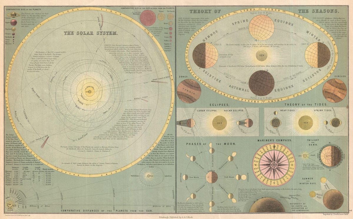
Adam and Charles Black had a monopoly on knowledge. Their publishing house, A&C Black, puts out medical dictionaries, almanacs, travel guides, and an annual Who’s Who. With “Solar System & Theory of the Seasons,” published in their General Atlas of the World, they moved beyond earthly concerns. On the left side, we get a comprehensive view of our space neighborhood—carefully drawn orbits of the planets (minus Saturn, Uranus or Neptune, which are left out “on account of their great distance”), orbital velocities, the contributions of notable comets, and even comparative sizes of the sun as seen from different parts of the solar system. On the right side, there’s a guide to the many ways in which our neighbors affect us, from lunar phases and tides to the four seasons and “twilight and dawn.”

With all of the new technology developed during the Industrial Revolution, our tools for observing the night sky became much more precise. By the end of the 19th century, scientists had long determined that the Earth wasn’t actually the center of everything, and that the universe is larger and infinitely more complex than they could ever imagine.
However, one persnickety “professor” took it upon himself to prove everyone else wrong. Professor Orlando Ferguson (a self-designated title), drew the Square and Stationary Earth Map for the express purpose of rectifying both scientific and biblical models of the world. What he came up with is this unique, inverse toroid (a fancy word for roulette wheel) shaped Earth, with the Moon, North Star, and Sun held in magnetic attraction by the North Pole. Harkening back to the celestial maps of old, Ferguson included four angels standing guard at each corner. He travelled around the Midwest touting his map by giving wide-ranging lectures and quoting the Bible verses that supported his theories.
As for what Ferguson thought of the scientists who made precise calculations about the shape of the Earth and the speed in which it rotates, he included some very telling imagery of men struggling to hold onto the planet as it zooms around, with the inscription:
“These men are flying on the globe at a rate of 65, 000 miles per hour around the sun, and 1,042 miles per hour around the center of the earth (in their minds). Think of the speed!”
This story originally ran in 2015; it has been updated for 2023.


Follow us on Twitter to get the latest on the world's hidden wonders.
Like us on Facebook to get the latest on the world's hidden wonders.
Follow us on Twitter Like us on Facebook