The ‘Folded Map’ Project Bridges the Distance Between Chicago’s Neighborhoods
Tonika Lewis Johnson, a local artist and activist, connects individuals from the North and South Sides through her art.
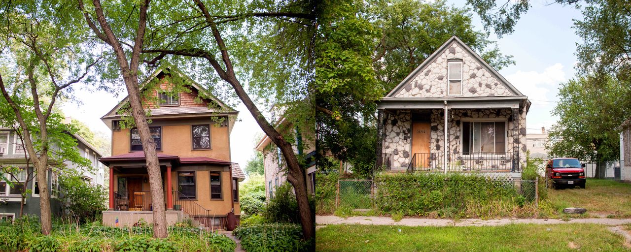
How do you find connections in a deeply segregated city? For the Chicago photographer and activist Tonika Lewis Johnson, the answer was simply to fold it in half. For her “Folded Map” project, Johnson photographed corresponding addresses on Chicago’s North and South Sides. She set the images side by side to highlight the impacts of decades of segregation and disparities in city resources.
That was how it began, at least. Johnson quickly discovered her subjects were also interested in getting to know one another. So she began connecting what she calls “map twins” and encouraged them to experience each other’s neighborhoods while she filmed the exchanges. To pair the map twins (there are currently four sets), Johnson used Google Maps to find matching addresses in the South Side Englewood neighborhood and on the far North Side, in the Edgewater and Rogers Park neighborhoods. Some were exact addresses while others were in the same area but on different blocks. Her photos were displayed alongside video conversations between the pairs at a Loyola University Museum of Art exhibit in 2018. Now, she is building a website to showcase “Folded Map” and connect future address pairs.
“The heart of ‘Folded Map’ illuminates our Midwestern sensibilities,” says Johnson. “Even though Chicago is huge, we still feel we should connect… We recognize when our city has a hand in not creating opportunities for us to get to know each other.”

Economic growth during the 19th and 20th centuries helped Chicago become a leader in industry, education, and cultural institutions. But racial and class segregation made it difficult for the city’s growing African-American and immigrant populations to access these resources. More than half a million African Americans came to Chicago as part of the Great Migration, forming a South Side “Black Belt” while immigrants from Eastern Europe, Latin America, Sub-Saharan Africa, and other areas built their own communities.
City, state, and federal policies as well as racial violence kept communities of color in certain areas during the 20th century. “Mapping Inequity: Redlining in New Deal America,” an online collection of federal Home Owners’ Loan Corporation maps and accompanying descriptions from 1935-1940, shows that in Chicago and cities around the country, black, Hispanic, and many Asian groups were segregated into neighborhoods deemed less desirable. Redlining, the process of refusing loans because of perceived financial risk, prevented many communities of color from owning homes and building generational wealth. White flight followed the construction of highways in largely African-American neighborhoods. Despite the passing of the 1968 Fair Housing Act that made housing discrimination illegal, little changed in Chicago.
As a result, the urban geography of Chicago became split by race: a black South Side separated by downtown from a white North Side and a largely Hispanic and black West Side. There are areas that defied segregation: The North Side Rogers Park neighborhood, which was included in “Folded Map,” is known for its racial diversity, with prominent Jewish Orthodox and African and South Asian immigrant communities. But in general, North, South, and West Side neighborhoods have been defined by inequitable distributions of educational, cultural, and economic resources.
These divisions continue to harm residents across races: A 2017 study by the Urban Institute and the Metropolitan Planning Council found that a decrease in Chicago’s segregation would increase per capita income for African Americans and educational attainment for both black and white residents. It would also decrease the homicide rate.

As a teenager, Johnson saw these divisions firsthand as she traveled from her South Side Englewood neighborhood to her magnet high school on the city’s North Side. While Johnson enjoyed the more varied economic and entertainment opportunities while living on the North Side after high school, she eventually found herself drawn back to her childhood neighborhood. In 2008, frustrated by the media narrative of gun violence on the South Side, Johnson began capturing rituals and normal goings-on for the photo project “Everyday Englewood.” Her images of children playing and families together were displayed at the Loyola University Museum of Art in 2018 and on five billboards around Englewood in 2017 as part of the Englewood Rising campaign. In 2011, Johnson also co-founded the Residents Association of Greater Englewood (RAGE), because “if the elected official won’t unify to create solutions, tangible solutions,” she says, “then the residents have to, which is nothing new.”
Building on these earlier projects, Johnson started “Folded Map” in 2017 to show that residents have the power to cross the invisible lines between neighborhoods. She says she wanted to portray both sides of the city with dignity because “for the residents who are trying to transform issues, people do tend to view them as victims but victims of their own circumstance or their neighborhood’s own circumstance. I wanted to push people to expand that thinking, to understand actually what you’re witnessing is resilience.”
Through Johnson’s guidance, which came in the form of a specific list of questions she asked each pair together, map twins discussed topics including race and socioeconomic status in each other’s living spaces. Describing some of the takeaways from those conversations, Johnson says South Siders are largely shocked by the price of homes in more affluent neighborhoods while North Siders are “realizing in that moment that they’re a beneficiary of inequity, and that’s difficult to realize in the face of someone who they want to get to know, telling them they’re on the opposite end of that.”
In 2017, Johnson paired Maurice “Pha’tal” Perkins, a community leader and rapper living in Englewood, with Jon and Paula Silverstein, who live in Rogers Park and work in an alderman’s office and for a foreign exchange program nonprofit respectively. Perkins says a highlight of making this connection was having the Silversteins attend a night-time bike ride and show genuine concern for a neighborhood that was not their own. “I’d like to think maybe it’s the start of a movement,” says Jon Silverstein of the project. “I’d love to see more and more people in the city start to build these relationships.”
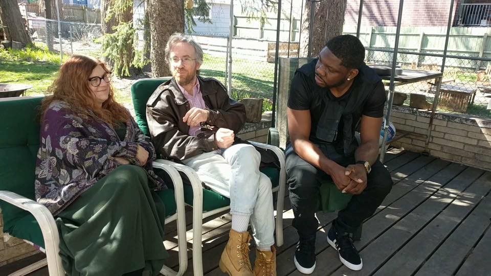
Brighid O’Shaughnessy, who was living in Rogers Park during her participation in the “Folded Map” project, and Carmen Arnold-Stratton, who lives in Englewood, formed another pair of map twins.
“What I got out of it was that there is still very much a division here in Chicago amongst people of various backgrounds and color,” says Arnold-Stratton, who works as a bus driver. “But Tonika [Johnson] brought people together that would have never otherwise come together or had gone to the other side of the city to see how other people lived.”
When O’Shaughnessy adopted her son from Haiti, she wanted to raise him in Rogers Park, where he could play outdoors. When she went to Arnold-Stratton’s residence in Englewood, they bonded over the fact that both had dealt with house break-ins. “We spoke pretty candidly about desiring safety and longed for a neighborhood where people had our backs,” says O’Shaughnessy.
O’Shaughnessy, who is a healer, artist, and activist, developed a theatrical version of “Folded Map” that she hopes will encourage the audience to think about “what is the narrative I’m holding about my own experience and what does it mean if I widen that narrative to include other communities I could engage with.”

Meanwhile, Johnson continues to build a future for “Folded Map.” Hundreds of Chicago residents have filled out an online form to express interest in participating and Johnson is beginning a second part of the project, photographing the city’s West Side. She is also embracing new undertakings as well: Building off her experiences commuting to school and raising two teenage children in the city, she started a project tentatively titled “Belonging,” focused on how youth of color navigate Chicago. For the future of “Folded Map,” she says she is excited about creators across the country exploring how their cities fold and how racial divisions can be bridged.
Ultimately, Johnson says “Folded Map” has taught her the importance of exploring how the design of a city controls how people interact. “I think it’s something that we forget,” she says. “The consequence of that is sometimes feeling guilty thinking that we contribute to whatever horrible inequity is in our city. When it really just shines a light on how we should all get together to demand more of our local government to change some stuff.”


Follow us on Twitter to get the latest on the world's hidden wonders.
Like us on Facebook to get the latest on the world's hidden wonders.
Follow us on Twitter Like us on Facebook