How to Get There From Here: Imaginary Transit Maps From Albuquerque to Westeros
Much has been written about the history of subway maps in New York City, from their aesthetic to their accuracy, their designers to their legions of riders. The same is true for the London tube, the Moscow subway, the Berlin U-Bahn, and on and on. Tracking the complicated dance of millions of people across the daily lives of major cities requires a comprehensive understanding of urban planning, mass psychology, and practical design.
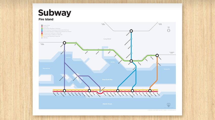 Imaginary Fire Island rail map (created by Transit Authority Figures)
Or does it? Whether out of frustration, wishful thinking, or just a firm conviction that it can be done, a great many laypeople have tried their hand at designing transit maps. Some of these stem from city familiarity and aspirational infrastructural reform — former Seattle Mayor Mike McGinn used an imaginary rail line map on some of his reelection campaign flyers, a grad student’s fantasy Pittsburgh transit map went viral last year, and City Data’s urban planning forum has a page for fantasy transit maps with hundreds of entries. Others are much more speculative and unlikely, such as the Fire Island map above (which is for sale as a poster here) or webcomic XKCD’s map of every subway line in North America linked together.
Here, for your armchair urban planning needs, are six more beautiful fantasy transit maps, from the practical to the fantastical.
Austin, Texas
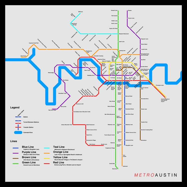 Imaginary Austin transit map (created by Ivan Specht)
The brainchild of eighth-grader Ivan Specht, Metro-Ology started as a Father’s Day present for his dad, who lives in Austin. Ivan designed the system he thought the city should have, showing a shrewd familiarity with the city’s layout and people’s movements. As he told Urban Omnibus, he wanted to “concentrate the number of stops and lines in the downtown areas, and to try to get an even balance throughout the city.” Since that first success, he’s made transit maps for cities all over the world, from Nuuk, Greenland, to Johannesburg, South Africa, all of which are for sale as posters and t-shirts on Metro-Ology. For $65, he’ll make a custom map for any city of your choice.
Albuquerque, New Mexico
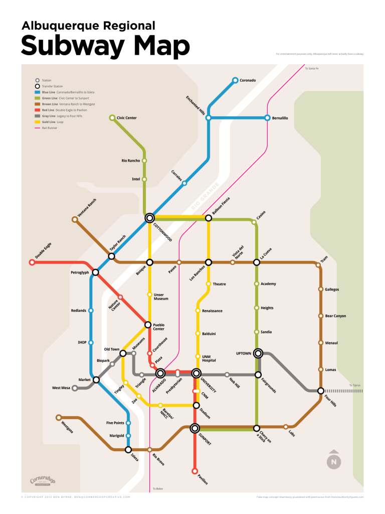 Imaginary Albuquerque transit map (created by Ben Byrne)
Taking inspiration from creative design agency Transit Authority Figures, which sells faux subway maps for Cape Cod, Fire Island, Northampton, and many more, graphic designer Ben Byrne made a fantasy subway map for his home city of Albuquerque. He designed it on a lark, but got such a strong response after posting it on his blog that he decided to Kickstart turning his “unique concept and piece of digital design into a genuine physical artifact.” The campaign was successful, and he’s now got a waiting list to buy his posters.
Greater Greater Washington Area
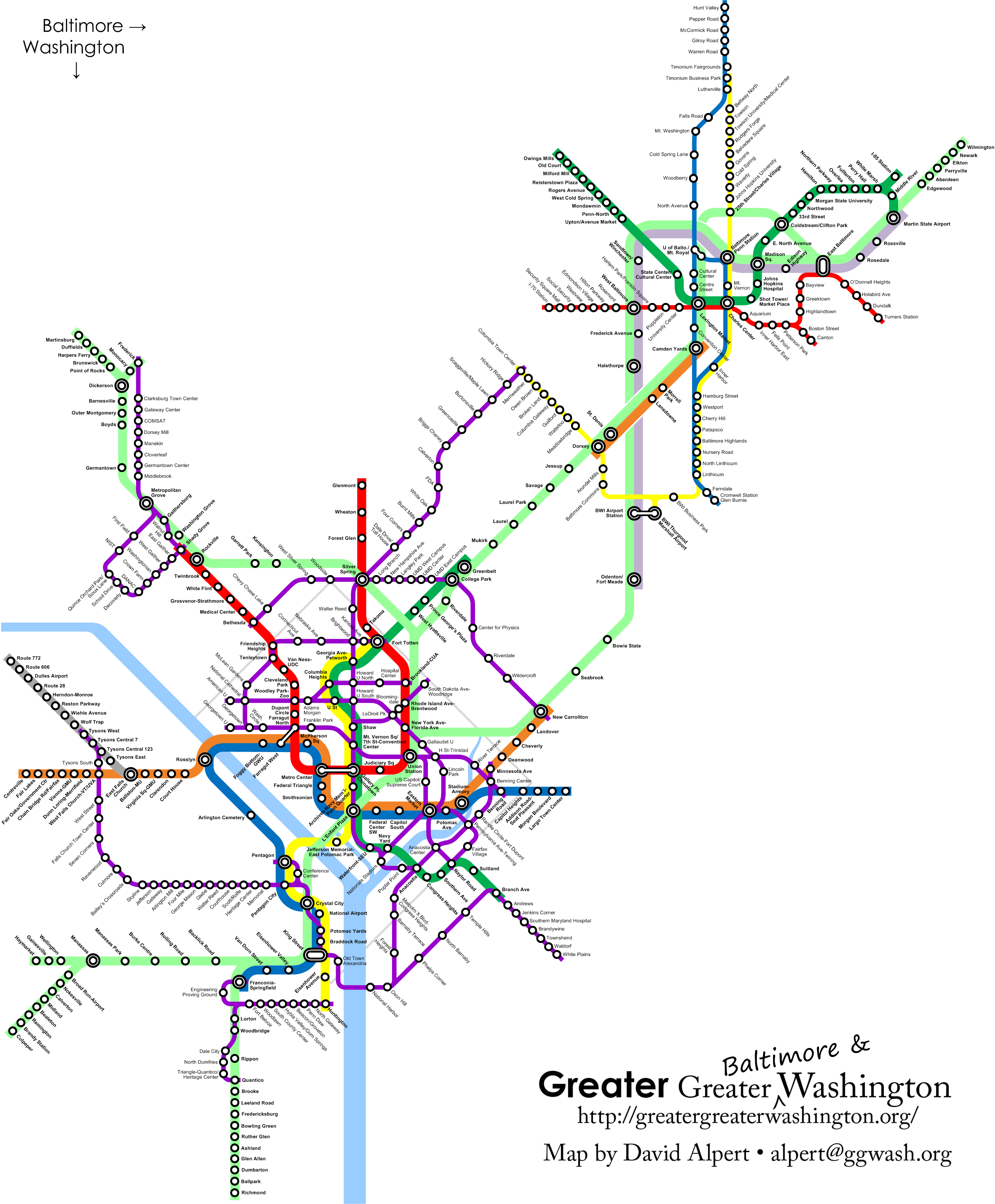 Imaginary greater Greater Baltimore & Washington Metro Map (created by David Alpert)
David Alpert, founder of the urban planning and transportation-focused site Greater Greater Washington, designed this fantasy transit map that is firmly grounded in reality. It takes as its starting point the extant Washington, DC metro system and extends it in all directions, adding new stops, actualizing proposed municipal initiatives, extending existing lines, and adding plenty of new ones. This is actually the second version of the fantasy map; after publishing the first, he took suggestions from his very engaged readership and made significant changes to reflect community feedback.
Baltimore, Maryland
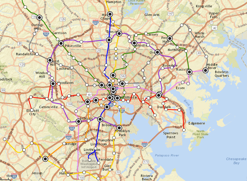 Subway restaurants as subway stations (created by Chris Nelson)
Also in the Washington, DC area, a Baltimore blogger made a subway map for his town that’s a bit less about urban planning and a bit more given to chance. Baltimore has only one subway line, but more than 140 Subway franchises, which naturally led Nelson, whose blog burgersub tracks homicides and plots them on Google maps, to his Subway / subway idea. As he told City Lore last year, “I like to imagine what my city would be like if I were running all the planning decisions.”
The Entire United States
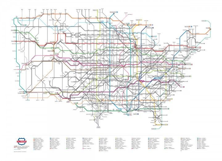
All the US highways as subway lines (created by Cameron Booth)
Australian graphic designer Cameron Booth runs a whole Transit Maps Tumblr, where he rates and reviews all kinds of maps, “whether they be real or imaginary, or from the past, future or present.” He curates images of official transit maps, improved transit maps, and dreamt-up maps of all sorts, as well as delights like a tiny 1980s LA tourist pamphlet map, a hyperlapse of a Seattle subway station, and a DC Metro map made of M&Ms. Naturally he also designs his own maps, and they’re extremely ambitious; the most complex is the map of the entire United States with its highways re-rendered as subway lines — the project took him over a year to complete.
Westeros
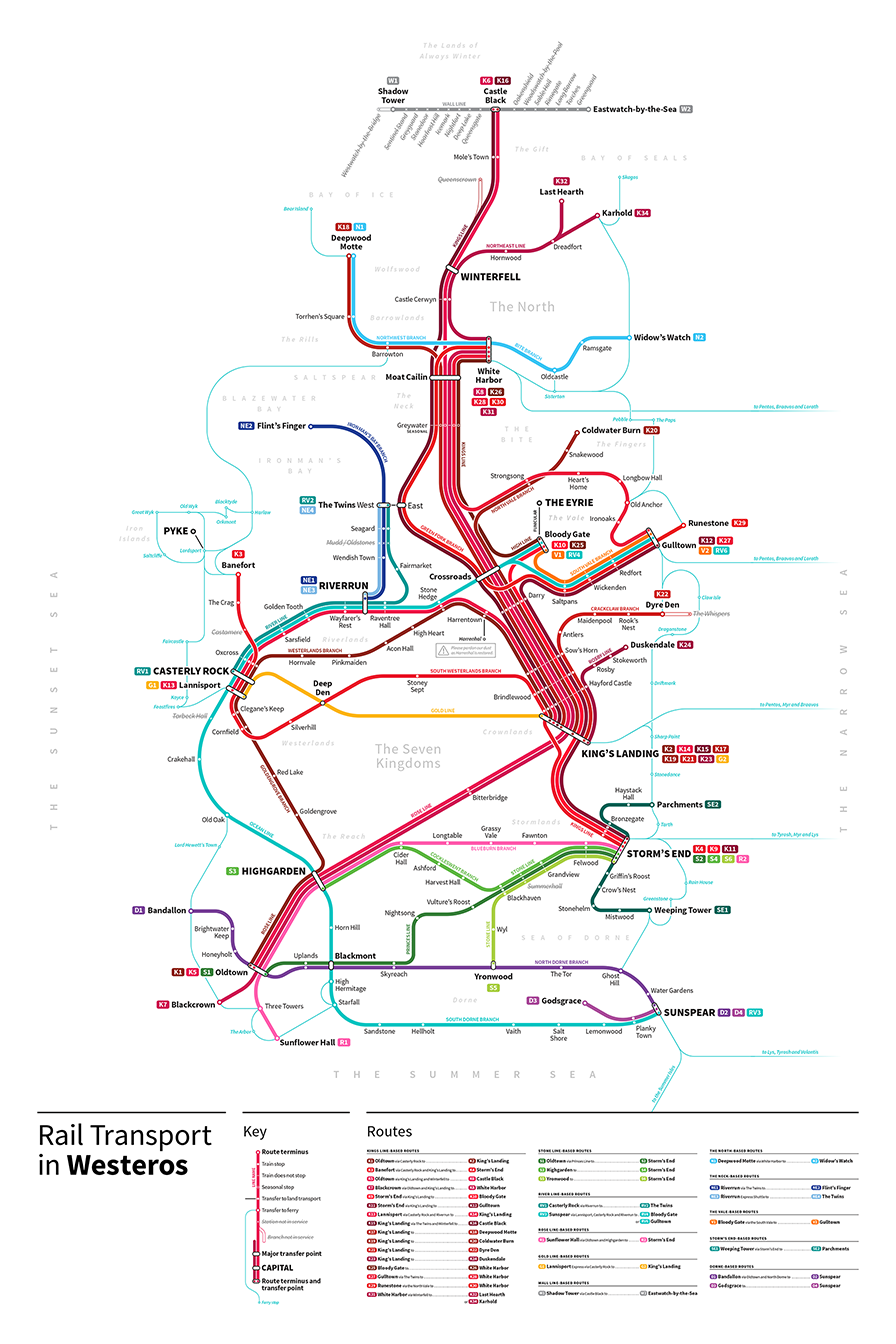 Westeros transit map (created by Michael Tyznik)
Inspired by Cameron Booth, graphic designer Michael Tyznik took the “fantasy” aspect of fantasy transit maps a big step further, mapping an imaginary system for an imaginary country: Westeros from Game of Thrones. Tynzik is no stranger to transit map design — he’s done light-rail maps of Columbus, Cincinnati, and more — and he brings that experience to bear for Westeros. It’s an incredibly comprehensive map, including ferry and gondola lines for those routes that require crossing bodies of water, as well as indicating which lines are closed or discontinued, coinciding with aspects of the saga’s plot.


Follow us on Twitter to get the latest on the world's hidden wonders.
Like us on Facebook to get the latest on the world's hidden wonders.
Follow us on Twitter Like us on Facebook