Matrimonial Maps Chart the Delights and Perils of Marriage
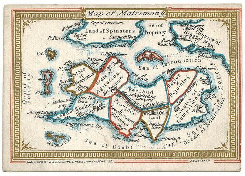 ‘Map of Matrimony’ by George Skaife Beeching, c1880. (Photo: Courtesy Barron Maps)
Cartography is all about creating accurate, detailed maps so that travelers know what to expect when setting out on a journey. But not all of these journeys involve physical travel—matrimonial maps provide a visual guide for the adventure that is courting, engagement, and marriage.
Matrimonial maps emerged in the 18th century, but were most prominent during the 19th century. They depicted states of emotion, milestones, and stages of intimacy in as geographical features. With these fanciful maps for reference, a single gal could chart a course from the Land of Spinsters to the Region of Rejoicing, bypassing Lonely Isle along the way. Likewise, unmarried gents could envision themselves setting off for a voyage from the Country of Single Men, navigating the choppy waters of the Sea of Introduction, and arriving in Valentine Bay, the gateway to the City of Dames.
Rod Barron, a British-based antiquarian book and map dealer, has assembled a delightful array of matrimonial maps dating from the mid-1700s to the 20th century. Below are some highlights from his collection.
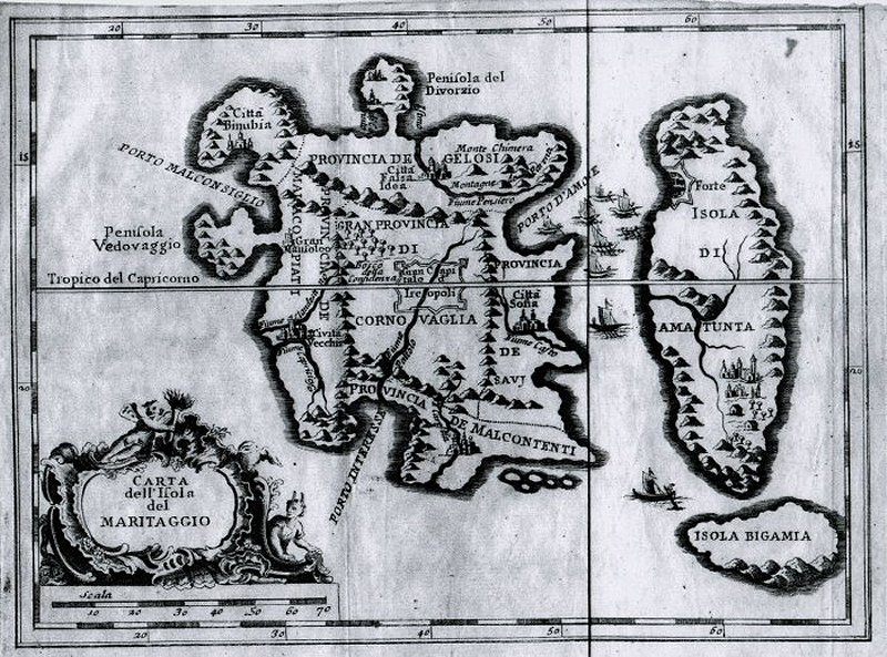 An Italian Matrimony Map from 1766 by Eustache LeNoble. (Photo: Courtesy Barron Maps)
Eustache le Noble, author of the map shown above, did time in “at least four French prisons” for crimes including forgery and adultery, writes Barron. During one of his prison stints, he fell in love with fellow inmate Marie-Gabrielle Perreau. Both were married to other people, but the two still went on the run together in 1695. Things ended badly—le Noble was re-arrested in 1697, and Perreau’s husband banished her to a convent, where she died in 1701.
Given all of this wretchedness, it’s no wonder the matrimonial map that le Noble created is a less-than cheery piece of cartography. With its central province of Cuckolds bordered by the Discontented, the Incompatible, and the Widowed, le Noble’s Island of Matrimony seems a bleak place indeed.
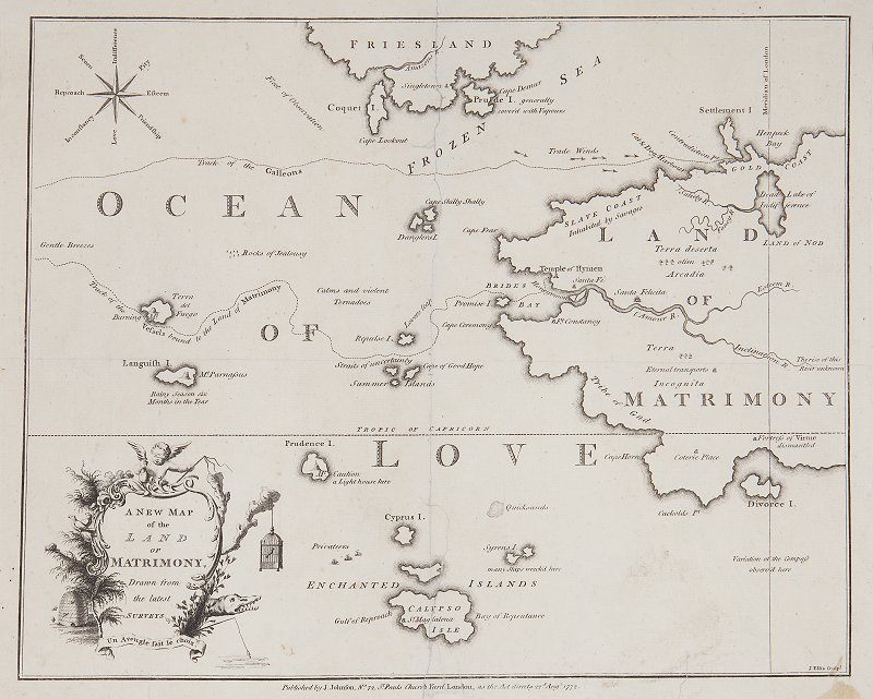 Land of Matrimony, Barbauld Johnson, 1772. (Photo: Courtesy Barron Maps)
The Land of Matrimony, created in 1772, ”boasts an assortment of interesting topographical features and settlements, many of which indicate the perils of a loveless marriage or one based purely on money and status,” writes Barron. Such perilous places include Henpeck Bay, the Dead Lake of Indifference, and Divorce Island, which is located right beside Cuckolds Point.
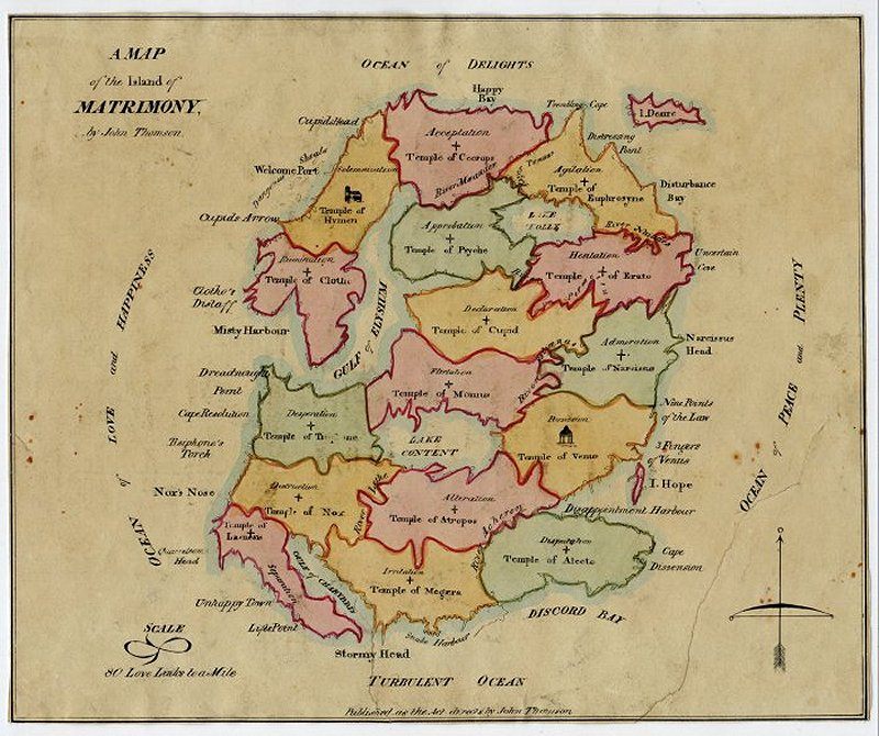 A Map of the Island of Matrimony, John Thomson, c1815. (Photo: Courtesy Barron Maps)
The work of Scottish cartographer John Thomson, the map above throws some classical mythology into the usual matrimonial mix. Temples scattered around the Island of Matrimony are named after Greco-Roman gods, Fates, and Furies. The province of Possession, for instance, contains the Temple of Venus, while the province of Approbation is home to the Temple of Psyche.
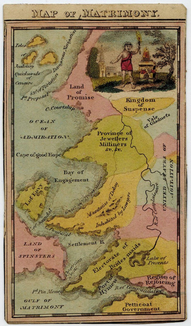
A Map of Matrimony, author unknown, from c1825. (Photo: Courtesy Barron Maps)
Created in the form of a voyage by an unknown author, the Map of Matrimony above is notable for its central Mountains of Delay, Inhabited by Lawyers. A triumphant Cupid stands at the top right holding a torch lit from an eternal flame that burns atop the Altar of Love.
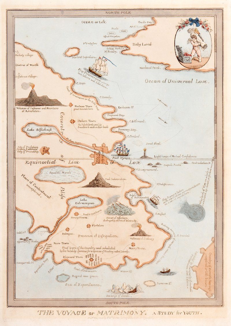 The Voyage of Matrimony: A Study for Youth, 1826. (Photo: Courtesy Barron Maps)
“The potential happiness of married life is alluded to in a couple of locations” within the above map, notes Barron, “though with no great enthusiasm from the author.” Samuel William Fores, the author in question, was married twice and reputed to have between 14 and 17 children. No doubt he spent some time wading in his own real-life version of Squabble Marsh, which is mapped beside Peak Indiscretion.
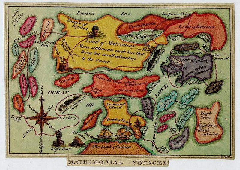 Matrimonial Voyages, c1820-30. (Photo: Courtesy Barron Maps)
The journey to marriage as depicted in Matrimonial Voyages above is meandering and fraught with peril. To get to the Land of Matrimony, a bachelor must resist the temptations lurking on St. Magdalen’s island, Coquette Isle, and Bacchus Isle. Should he not be dashed upon the Rocks of Disappointment, he will eventually arrive at the Land of Matrimony, after which his final task is to seek entry to the Temple of Hymen.
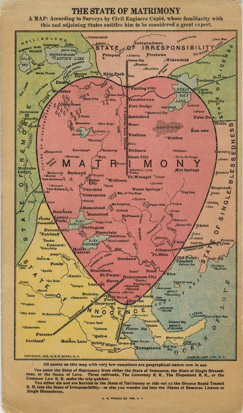 The State of Matrimony, GA Moray, 1909. (Photo: Courtesy Barron Maps)
Matrimonial maps survived into the 20th century, as evinced by the above creation, designed and published by New York restaurant owner George Edward Moray to promote his two eateries. This map is unusual in that the vast majority of the locations plotted are real place names. Three railroads labeled Ceremony, Elopement, and Common Law run into the State of Matrimony, while the Divorce Rapid Transit railroad runs out.
Map Monday highlights interesting and unusual cartographic pursuits from around the world and through time. Read more Map Monday posts.


Follow us on Twitter to get the latest on the world's hidden wonders.
Like us on Facebook to get the latest on the world's hidden wonders.
Follow us on Twitter Like us on Facebook