Society Adventures: The Harrowing Remains of a Forgotten California Dam Disaster
The dam before the disaster (via documentingreality.com)
When it collapsed on March 12, 1928, St. Francis Dam became — and still is — the second worst disaster in California’s history, and the greatest civil engineering failure of the 20th century. There are no living witnesses to the break itself, and there is much debate over where the blame should be placed, as well as over exactly how great was the loss of human life. Shortly after the centennial celebration of the Los Angeles Aqueduct, the Los Angeles Obscura Society gathered at the dam site to explore its incredible ruins, and to learn how Santa Clarita and San Francisquito Canyon have figured prominently in the water and power supply for Los Angeles.
Second only to the San Francisco Earthquake (and resulting fires) in terms of death toll, the “official” number of those lost to the flood is 450, but it’s likely many more given the undocumented immigrant workers who were living in encampments along its path. Over 12 billion gallons of water rushed down San Francisquito Canyon, from Santa Clarita, 54 miles all the way out to the Pacific Ocean — carrying everything in its path, including trees, houses, livestock, and people, along with it.
The rebuilt Power Plant #2, with penstocks behind the building (via Avoiding Regret)
The dam was built to create an emergency reservoir for Los Angeles’ water supply, which was being fed at the time primarily by the Los Angeles Aqueduct. Situated between Power Plant #1 (up San Francisquito Canyon Road) and Power Plant #2, this was 1.3 miles downstream from where the dam once stood. Although the building for Plant #2 was completely destroyed by the flood (spare its turbines, two of which are still functional today), Power Plant #1 — first put into service in 1917 to control the water flowing down to Los Angeles from the Owens Valley — was fortunately located upstream and survived the disaster, and remains today.
Our LADWP tour guide, Ron, taking us into Power Plant #1 in San Francisquito Canyon (via Avoiding Regret)
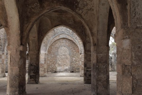
In December, the Obscura Society was led on a private, detailed tour of the working power plant, with water audibly rushing through the pipes, letting gravity bring water from the Aqueduct into the plant to be converted into power.
Viewing the massive (and loud!) equipment that controls water from the LA Aqueduct and converts it into electrical power (via Avoiding Regret)
Technology hasn’t changed much in the last century, and much of the equipment is original, though some of it has been upgraded (mostly to increase efficiency) and other machinery requires the occasional repair. However, for the most part, while standing in this facility, you experience working history that most people never visit, or even know about.
Belt-driven pump (via Avoiding Regret)
The Los Angeles Department of Water and Power staff not only work at Power Plant #1, but live there, too — in Pelton, an unincorporated company town with cabin-like residences, where workers can arrive quickly if needed. This plant never stops working, and is staffed and monitored every day, all day, and night.
The board at Power Plant #1 that actually controls six power plants in the region, 24/7 (via Avoiding Regret)
In fact, its control room holds knobs, switches, buttons, alarms, and monitors not only for the performance of this power plant, but for a total of six power plants in the region.
The “Tombstone”
We knew that much of what had originally been left standing of the dam — the center section, later nicknamed “The Tombstone” — had been blasted with dynamite after it took its final victim: a young boy who climbed to its top and fell off a year after the dam broke. We also knew that the rushing waters had broken the rest of the massive concrete dam into numerous pieces, most of which were washed downstream. But since some larger and heavier ones didn’t make it very far, we set out to find whatever was left of the St. Francis Dam, and to remember those lost.
Rebar in rubble from the Tombstone (via Avoiding Regret)
When the dam broke only two years after its completion, it wasn’t even known to most of the residents in the area. It didn’t open with the same fanfare as the aqueduct with its grand opening at the Cascades in 1913. When residents situated downstream from the flood were warned of the oncoming wall of water, many replied, “From where?”
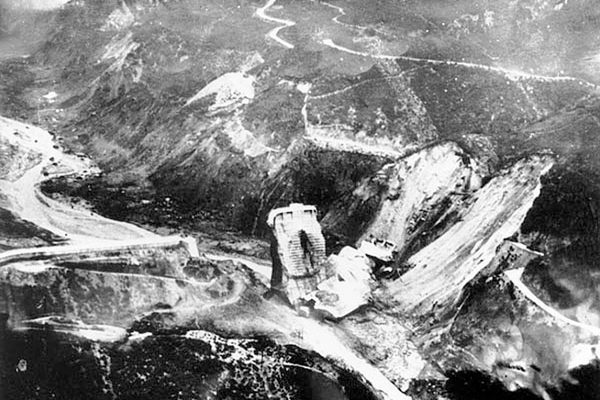
The remaining rubble from the dynamited Tombstone, as seen from above (via Avoiding Regret)
Even today, the dam disaster site is relatively obscure, even to residents of Los Angeles County. Parking our cars in a turnout off of San Francisquito Canyon Road (which was once filled with water when the dam stood), traveling down Old San Francisquito Canyon Road (which was decommissioned in the 2000s after storms washed it out), we came upon a recognizable pile of rubble, all that remains from when the Tombstone was blasted. Since then, enough people have visited the disaster site that their footsteps have flattened the remnants, grinding much of the concrete into a fine powder, reducing the 200-foot wall to gravel and rebar. It can be seen from the road or hiked to, but our Obscura Society members — stalwart explorers that they are — braved a windy day during a rare Southern California cold snap to climb a steep ridge to see the disaster site from above.
San Francisquito Canyon today, where the “bowl” of the dam once held water (via Avoiding Regret)
It was this aerial view which really revealed the scale of the former reservoir, whose contents created a wall of water initially 180 feet high, racing down the Santa Clara River Valley, wiping out everything in its path of destruction.
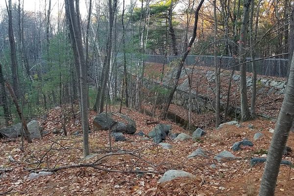
Walking along the remaining wing of the dam’s dike to the west abutment (via Avoiding Regret)
The best-preserved section of the St. Francis Dam is along the west abutment, which was leaking groundwater at the time of the disaster, but not enough to make it break in the way that it did. The real problem was in the east abutment, where movement from an ancient Paleolithic landslide in the schist rock (along what is now known as the San Francisquito Canyon Fault) was so dramatic and quick, even the road had moved several feet in one day. The entire east abutment of the dam is now gone, leaving only a scar in the canyon wall.
On the west side, however, a 588-foot-long wing dike had been built along the top of the ridge to the west abutment in order to accommodate a ten-foot increase in the dam’s height from its original 1923 plan — one of Chief Engineer William Mulholland’s many decisions that may have contributed to (or certainly didn’t prevent) the disaster’s occurrence. If you can weather the wind and the steep trail up to the top of the ridge to get to it, it is very much worth the trip.
Many thanks to the Los Angeles Department of Water and Power for the tour of Power Plant #1, and to the participants who bundled up for a cold day of exploration!
The Obscura Society is the real-world exploration arm of Atlas Obscura We seek out secret histories, unusual access, and opportunities for our community to explore strange and overlooked places hidden all around us. Join us on our next adventure!
All Upcoming Obscura Society Events
Facebook: Obscura Society San Francisco


Follow us on Twitter to get the latest on the world's hidden wonders.
Like us on Facebook to get the latest on the world's hidden wonders.
Follow us on Twitter Like us on Facebook