The Long History of the Mind-Bending ‘Tiny Planet’ Panorama
Spherical landscapes helped an 18th-century scientist convey the enormity of the Alps.
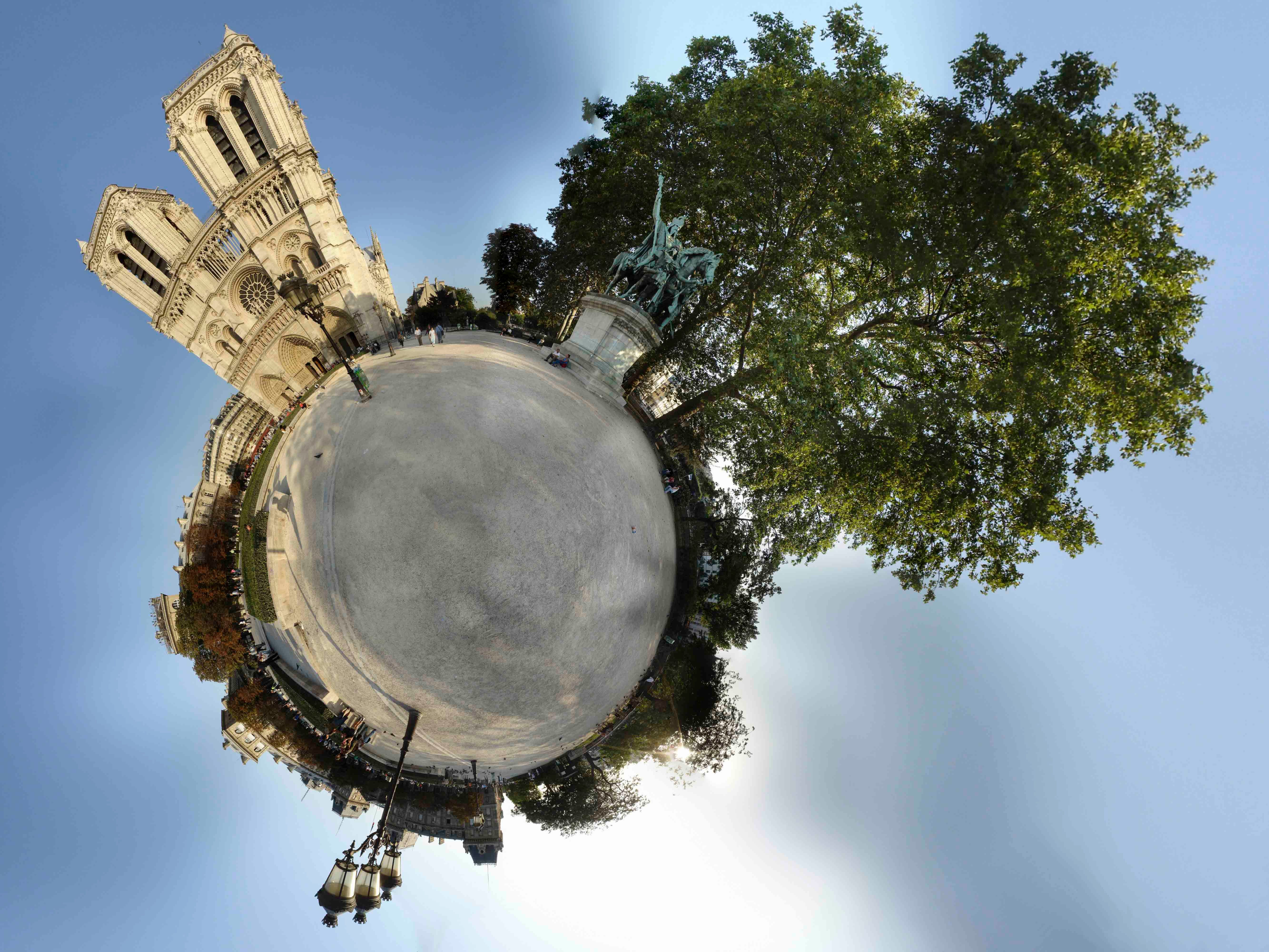
Instagram is full of photo trends, but one of the most visually stunning is #tinyplanet. A circular, instead of horizontal, panorama, the tiny planet is an immersive photo that stitches together the entire environment to otherworldly effect. The ground appears like a small, green planet and buildings, people, plants, animals, and trees all shoot and soar around the little sphere. The technique became a popular way to rethink the panorama of the iPhone, but this spherical landscape was pioneered over 200 years ago and helped spread the idea of immersive pictures.
During the 18th century, a new world opened in two ways: One, scientists started to investigate and explore the mountains with a new perspective on studying and capturing the natural world; and two, balloon technology appeared that allowed people to see the world from above, looking down. Scientists pioneered circular landscapes to try to capture these new perspectives. Horace Bénédict de Saussure is perhaps the most famous of these trailblazing designers. He is not as well-remembered as his early 20th-century descendant Ferdinand de Saussure, who wrote about semiotics in linguistics, but the older Swiss aristocrat contributed significantly to the study of geology and meteorology through his detailed descriptions and natural history of the Alps.
Originally from Geneva, de Saussure conducted numerous scientific expeditions among the alpine slopes, documenting his attempts to reach Mont Blanc and the other peaks. Published from 1779 to 1796, his multi-volume text Les Voyages dans les Alpes was an important natural history of the mountains and inspiration to other geologists. His work would lead to the explosion of tourism in the mid-19th century. Although Thomas Manning, one British contemporary, wrote to his friend, the great Georgian essayist Charles Lamb, “the views in Switzerland are far inferior, I think, to those in North England,” the illustrations that accompanied de Saussure’s publications transported the reader into the center of the precipitous mountain glaciers.

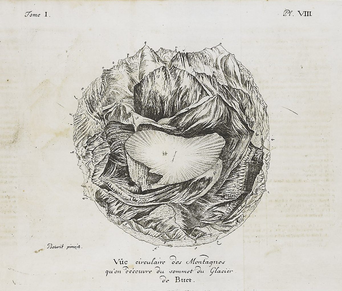
In 1776, de Saussure was a member of a team that was among the first to reach the summit of Mont Buet in France. He and his colleagues were primarily interested in collecting meteorological data and specimens of shell fossils, “the most singular petrifications … previously unknown to Naturalists.” Upon reaching the summit, the team was spellbound by the beauty of the surrounding mountains. De Saussure knew he wanted to share such a landscape with his readers, but he struggled with how he might illustrate the immensity and towering nature of the surroundings. “I saw clearly that it would be impossible to give to my Readers a little clear idea without joining my designs there,” he wrote.
From the Renaissance onwards, artists resurrected and perfected the practice of linear perspective to realistically portray objects in front of a viewer. First drawing a straight horizontal line on the canvas, the artist could establish the same distant horizon in front of the viewer. Then, the artist would pick a central point, known commonly as the vanishing point, that represented the “perspective” of the viewer toward the horizon; and from that point, the painter drew orthogonal lines to create the realistic effect of three-dimensional space.
However, linear perspective was limited in focusing on a single view of a landscape. Creative artists, in the subsequent years, found innovative ways to play with multiple views in perspective; but in general, if an artist bound themselves to realism, landscape painting could only show a single frame in front of the viewer.
While on the summit of Mont Buet, de Saussure had an idea to resolve this conflict:
“Following the method I have employed, the Designer paints the objects exactly as he sees them by turning the paper in proportion to how he turns himself. And those who after his work wish to form an idea of the objects he has defined have but to arrange themselves as though they are placed in the center of the design, adding by the imagination what they see in the middle of the center, and making, by turning the design, the review of all its parts. They see successively all the objects outlined among them, and absolutely what it presents to an Observer situated on the summit of the mountain.”
To this end, de Saussure commissioned Marc-Théodore Bourrit, one of the members of the team, to design such a circular landscape. A Genevan mountaineer himself, Bourrit published numerous illustrations of the Alps throughout the 18th century; and when asked to limn de Saussure’s idea, he attempted the 360-degree perspective of the summit of Mont Buet, “with enthusiasm…and the happiest of success,” according to de Saussure.

For the design, Bourrit stood at the top of the mountain, which is the center of the circular landscape, and he faced Mont Blanc. Instead of a line, he drew a circle for the horizon. He turned and progressively drew in perspective from that position until he had made an entire revolution. Thus, with the resulting circle drawing, he was able to realistically show the relative height and depth of the mountains in the scene.
According to Saussure’s description of the map-like painting, the “spectator is supposed to be placed in the center of the figure.” To orient oneself, the viewer should begin with finding the letter a, which is printed above the peak of Mont Blanc, the highest mountain in Europe. Left of the 15,777-foot summit, between the letters a and s, the viewer can see the gradient and path one follows to descend from the mountain into the rest of the alpine chain. Further left rotation brings one to the Argentière Glacier. Other physical formations visible from the center are the l’Aiguille and the Glacier du Tour.
De Saussure’s view of Mont Buet is a revolutionary perspective on landscapes. While Thomas Baldwin published another circular landscape in Airopaidia, the circular landscape would not penetrate the public’s consciousness until the 19th century. Other examples of immersive artwork, such as Robert Barker’s “Apparatus for Exhibiting Pictures,” used wall paintings inside a building so that the individual could feel as if they were in a virtual space. These spaces were popular in London and Paris, and it’s in reviews for these art installations we find the first coinages of panorama. Barker’s success surpassed the niche scientific publications of Saussure and Baldwin; but together those two innovators offered a unique vision of the word, the first images of #tinyplanet.


Follow us on Twitter to get the latest on the world's hidden wonders.
Like us on Facebook to get the latest on the world's hidden wonders.
Follow us on Twitter Like us on Facebook