What We Can Learn From Mapping a Massive Underwater Volcano
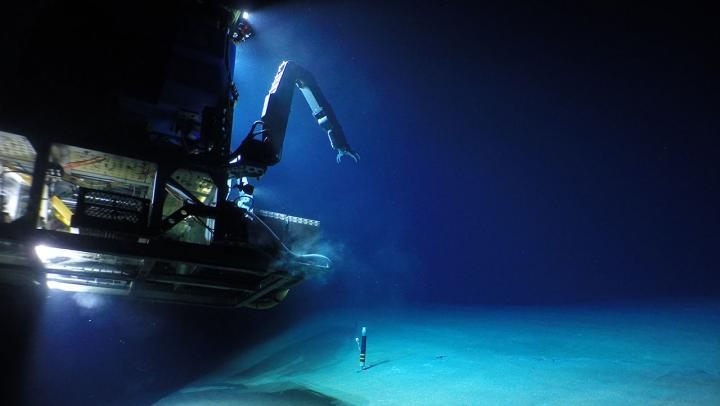
Researchers sent an autonomous underwater vehicle and a robot to study Havre, which erupted in 2012.
The ocean’s deepest depths are home to wrecks, artifacts, and forms of life that can thrive in a wide-open sensory deprivation chamber. But the seafloor is also stippled with volcanoes, and they’re pretty busy. More than 70 percent of eruptions on Earth occur at the bottom of the ocean, where inky water obscures our view of the explosive activity and presents challenges for scientists who want to study it.
One telltale sign of an aquatic eruption is a surfeit of pumice drifting to the surface. The porous rocks are buoyant because gas bubbles get trapped when scalding lava meets the water. When enough of these pockmarked rocks bob in tandem, they form unmoored islands. One of the biggest of these took shape in 2012, when a volcano called Havre, northeast of New Zealand, spit out a pumice raft measuring 150 square miles—roughly the size of the Isle of Wight.
The surface evidence pointed to a big event on the seafloor, and researchers wanted a closer look. “We knew it was a large-scale eruption, approximately equivalent to the biggest eruption we’ve seen on land in the 20th century,” said Rebecca Carey, a volcanologist at University of Tasmania, in a statement.
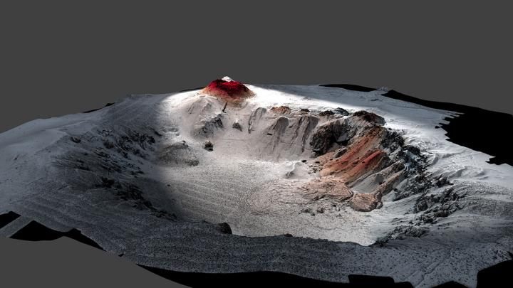
Exactly how submarine volcanoes operate, and how they differ from ones on land, remains a bit of a puzzle. It’s relatively unusual for scientists to visit an underwater site soon after eruption. So, in 2015, with support from the National Science Foundation, Carey and other researchers from the Woods Hole Oceanographic Institution, University of Tasmania, University of California Berkeley, and University of Otago in New Zealand boarded a research vessel and dispatched an autonomous underwater vehicle (AUV) and a robot named Jason over 2,000 feet down to map portions of the three-mile caldera and its crater.
In a new paper in the journal Science Advances, the researchers conclude that the evidence left behind on the ocean floor isn’t necessarily a good proxy for the magnitude of an undersea explosion. They determined that Havre spewed ash, lava domes, and seafloor lava flows, and was comparable to the 1980 eruption of Mount St. Helens, whose column unloaded ash across 11 states.
In the case of Havre, though, a lot of this physical evidence drifted away, and washed up on beaches. (Still, the stuff that did stay put is pretty remarkable: One researcher noted that the AUV’s reading showed such big bumps on the seafloor—some the size of vans—that he initially assumed the sonar was glitching.)
On land, eruptions of that magnitude can wreak a sizable toll on the surrounding ecosystem. When Mount St. Helens blew, the explosion uprooted trees in a “blowdown zone” reaching 143 square miles. Blankets of ash choked out plants and animals, and the scorched landscape was still rebounding three decades on. Carey told Newsweek that this research lays the groundwork for future investigations into the long ecological tail of underwater eruptions. There’s much more to learn about what happens when harsh conditions become even less hospitable.


Follow us on Twitter to get the latest on the world's hidden wonders.
Like us on Facebook to get the latest on the world's hidden wonders.
Follow us on Twitter Like us on Facebook