Trips Places Foods Stories Newsletters

Take your next trip with Atlas Obscura!

Our small-group adventures are inspired by our Atlas of the world's most fascinating places, the stories behind them, and the people who bring them to life.

Visit Adventures
Trips Highlight
Taktsang Lhakhang, also known as the “Tiger’s Nest”.
Bhutan • 11 days, 10 nights
Festivals & Temples of Bhutan
from
Macchu Picchu
Peru • 10 days, 9 nights
Peru: Machu Picchu & the Last Incan Bridges
from
View all trips
Loading...
Loading...
Loading...

No search results found for
“”

Make sure words are spelled correctly.

Try searching for a travel destination.

Places near me Random place

Popular Destinations

  • Paris
  • London
  • New York
  • Berlin
  • Rome
  • Los Angeles
Trips Places Foods Stories Newsletters
Sign In Join
Places near me Random place
All the United States Oregon Valley Falls Abert Rim

Abert Rim

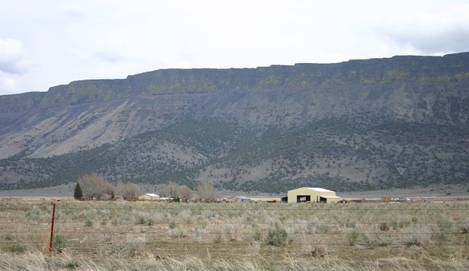
This spectacular fault escarpment, a popular hang-glider launch point, extends some 30 miles long and towers about 2,500 feet over the valley floors to the west.

Valley Falls, Oregon

Added By
slgwv
Email
Been Here
Want to go
Added to list
CAPTION
Abert Rim from US-395 near Valley Falls.   slgwv / Atlas Obscura User
Abert Rim from US-395 (the highway to left), looking north.   slgwv / Atlas Obscura User
View southwest from Abert Rim near Tague’s Butte launch point.   slgwv / Atlas Obscura User
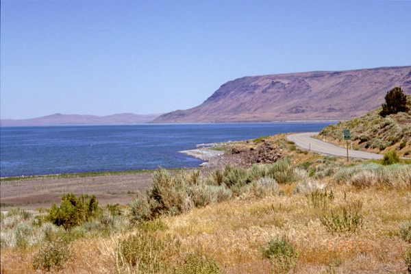
View northwesterly along Abert Rim with Lake Chewaucan in the distance..   slgwv / Atlas Obscura User
Looking northwesterly from the vicinity of Tague’s Butte toward the Summer Lake valley. The distant skyline is Winter Ridge.   slgwv / Atlas Obscura User
Abert Rim from US-395 near Valley Falls, in late afternoon light.   slgwv / Atlas Obscura User
Looking north along the Abert Rim from near Tague’s Butte.   slgwv / Atlas Obscura User
View northwesterly from near the Tague’s Butte launch site.   slgwv / Atlas Obscura User
View northwesterly from the vicinity of Tague’s Butte toward the Summer Lake valley. The distant skyline is Winter Ridge.   slgwv / Atlas Obscura User
Looking south along Abert Rim from the vicinity of Tague’s Butte.   slgwv / Atlas Obscura User
Looking north along the Abert Rim from the vicinity of Tague’s Butte.   slgwv / Atlas Obscura User
Telephoto view of the Abert Rim scarp from US-395.   slgwv / Atlas Obscura User
View northwesterly along Abert Rim with Lake Abert appearing over the ridge in the foreground.   slgwv / Atlas Obscura User
View west from around Tague’s Butte to the Gearhart Mountains. US-395 is in the valley below.   slgwv / Atlas Obscura User
Abert Rim from US-395 near Valley Falls.   slgwv / Atlas Obscura User
Been Here
Want to go
Added to list

About

Located in south-central Oregon, the Abert (pronounced "AY-bert") Rim is said to be the longest exposed fault scarp in the United States, at some 30 miles (50 km) in extent. It's also one of the highest, with around 2,500 feet (~760 meters) of relief. The rim is topped with a thick (>800 feet; 245 meters) sequence of basalts that commonly forms a prominent dark capping cliff. These basalts are part of the extensive basalt eruptions centered around Steens Mountain some 80 miles east.

The Abert Rim is paralleled by US-395 on the west for most of its length. The rim was formed by crustal extension due to Basin and Range faulting, which extends into Oregon here. The faulting has occurred within the last ten million years or so.

The rim is spectacular from below, but also provides breathtaking views from its crest. One of the easiest access points to the crest, sometimes called Tague's Butte after a hang-gliding enthusiast who popularized it, is near the southern end. As might be expected, this point is also a popular site for hang-glider launches.

The Abert Rim (and nearby Abert Lake) were named for John James Abert by explorer John C. Frémont, who came through this area in 1843. Abert was the head of the Corps of Topographical Engineers, which carried out explorations in the west before the U.S. Civil War, and he had authorized Frémont's expedition.

Related Tags

Landscapes Volcanoes Extreme Sports Geology

Know Before You Go

As mentioned, Abert Rim is visible all along US 395 for about 25 miles, from south of Valley Falls, Oregon northward.

To get to Tague's Butte, the most accessible viewpoint (and hang-glider launch site) on the rim, take Oregon State Route 140 8.0 miles east from its junction with US-395 north of Lakeview to the junction with USFS Road 3615 (at about 42.22548 N, 120.23088 W). Follow it north from OR-140 20.8 miles to the turnoff (at about 42.42285 N, 120.210836 W) to the viewpoint/hang-glider launch (aka Tague's Butte). Turn left here and go 0.7 miles up to the overlook/launch point, at roughly 42.43070 N, 120.21768 W.  High clearance will probably be necessary on this last segment.

There are several primitive campgrounds in the vicinity. One, Mud Creek Campground, is right on USFS Road 3615; you pass it on the right about 6.2 miles in. A rustic cabin, Aspen Cabin, is off the road 7.3 miles in and can be rented from the Forest Service, but typically requires a reservation well in advance. Check the Fremont-Winema National Forest site for other campgrounds and cabins, as well as for places where primitive car camping ("boondocking") off established roads is allowed.

Gasoline and commercial RV camping are available in Valley Falls, where Oregon State Route 31 turns off to the northwest. Otherwise, the nearest full services are in Lakeview, Oregon, about 22 miles south of Valley Falls on US-395.

Community Contributors

Added By

slgwv

Published

March 28, 2024

Edit this listing

Make an Edit
Add Photos
Sources
  • http://www.oregonsoutback.com/todo/hanglide/tagues.html
  • Orr, Elizabeth L.; Orr, William N. Geology of Oregon, 5th ed., Kendall/Hunt Publishing Co., 2000, pp. 85-86.
  • https://www.flickr.com/photos/blmoregon/15156541104
  • https://www.facebook.com/BLMOregon/photos/a.142647002423774.24515.121189811236160/1296176717070791/?type=3&theater
Abert Rim
Valley Falls, Oregon, 97630
United States
42.433086, -120.215836
Visit Website

Nearby Places

Lake Abert

Valley Falls, Oregon

miles away

Old Perpetual Geyser

Lakeview, Oregon

miles away

Fremont National Recreation Trail

Paisley, Oregon

miles away

Explore the Destination Guide

Photo of Valley Falls

Valley Falls

Oregon

Places 2

Nearby Places

Lake Abert

Valley Falls, Oregon

miles away

Old Perpetual Geyser

Lakeview, Oregon

miles away

Fremont National Recreation Trail

Paisley, Oregon

miles away

Explore the Destination Guide

Photo of Valley Falls

Valley Falls

Oregon

Places 2

Related Places

  • Painted Dunes from the top of the adjacent cinder cone.

    Old Station, California

    Painted Dunes

    Sunset-colored dunes of volcanic ash make taking a poor photo impossible.

  • The Green Lagoon.

    Yaiza, Spain

    Green Lagoon

    This beautifully verdant lagoon is tucked below a massive volcano in a crater atop a black pebble beach.

  • Tumuli near Byaduk

    Byaduk, Australia

    Tumuli Lava Blisters

    These naturally occurring but rare geological formations are each about the size of a small house.

  • Fragokefala at Lemnos

    Lemnos, Greece

    Volcanic Rocks of Lemnos

    An alien landscape on the banks of the Aegean Sea.

  • A beach on the island with distinctive rock formations.

    Malpe, India

    Thonsepar

    These four small islands contain unique hexagonal rock formations.

  • Window arch in the City of Rocks.

    Almo, Idaho

    City of Rocks

    This U.S. natural reserve is an ancient spiritual place and rock climber’s paradise.

  • Approaching the south rim of Easy Chair Crater on the trail..

    Nye County, Nevada

    Easy Chair Crater

    An unusual double cinder cone with a bent oval crater, in the Lunar Crater Volcanic Field.

  • A view of the perfectly round Lac Pavin.

    Besse-et-Saint-Anastaise, France

    Lac Pavin

    This volcanic crater lake is renowned for its perfectly round shape, stunning blue-green waters, and unique geological properties.

Aerial image of Vietnam, displaying the picturesque rice terraces, characterized by their layered, verdant fields.
Atlas Obscura Membership

Become an Atlas Obscura Member


Join our community of curious explorers.

Become a Member

Get Our Email Newsletter

Follow Us

Facebook YouTube TikTok Instagram Pinterest RSS Feed

Get the app

Download the App
Download on the Apple App Store Get it on Google Play
  • All Places
  • Latest Places
  • Most Popular
  • Places to Eat
  • Random
  • Nearby
  • Add a Place
  • Stories
  • Food & Drink
  • Itineraries
  • Lists
  • Video
  • Podcast
  • Newsletters
  • All Trips
  • Family Trip
  • Food & Drink
  • History & Culture
  • Wildlife & Nature
  • FAQ
  • Membership
  • Feedback & Ideas
  • Community Guidelines
  • Product Blog
  • Unique Gifts
  • Work With Us
  • About
  • FAQ
  • Advertise With Us
  • Advertising Guidelines
  • Privacy Policy
  • Cookie Policy
  • Terms of Use
Atlas Obscura

© 2025 Atlas Obscura. All Rights Reserved.