Trips Places Foods Stories Newsletters
Loading...
Loading...
Loading...
Loading...

No search results found for
“”

Make sure words are spelled correctly.

Try searching for a travel destination.

Places near me Random place

Popular Destinations

  • Paris
  • London
  • New York
  • Berlin
  • Rome
  • Los Angeles
Trips Places Foods Stories Newsletters
Sign In Join
Places near me Random place
All the United States Nevada Reno Airmail Arrow
AO Edited

Airmail Arrow

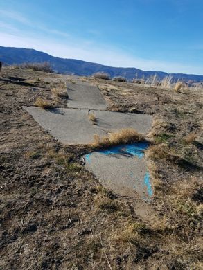
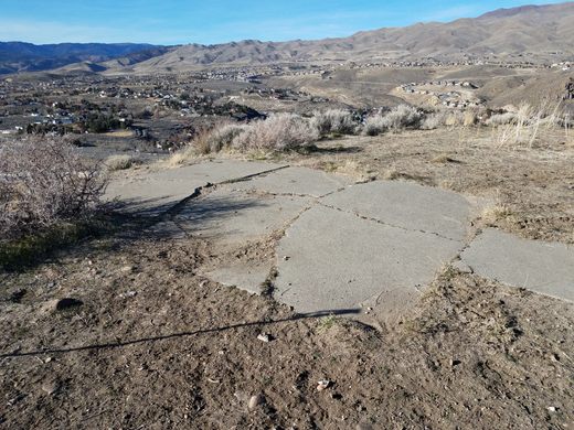
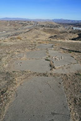
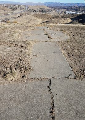
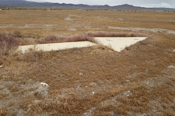
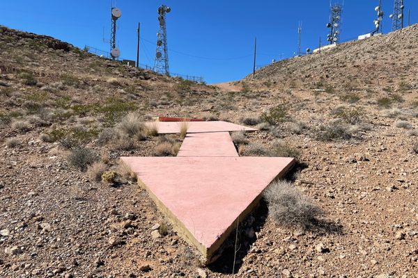
A concrete arrow from a 1920s network of airmail beacons is still preserved at the western edge of suburban Reno.

Reno, Nevada

Added By
slgwv
Email
Been Here
Want to go
Added to list
CAPTION
Tip of the arrow, looking back west. The skylined mountains are Boca Ridge in California. The blue paint is _not_ original.   slgwv / Atlas Obscura User
Base of the arrow, looking northwesterly.   slgwv / Atlas Obscura User
The arrow pointing east to Reno.   slgwv / Atlas Obscura User
The arrow. Looking east (where the arrow’s pointing); Reno, Nevada in the distance.   slgwv / Atlas Obscura User
Looking north down the ridge to the arrow, which is at the edge of the cleared area just before the break in slope beyond.   slgwv / Atlas Obscura User
The “Hole in the Wall”, a tunnel for the irrigation ditch. This is the nominal trail destination. To reach the arrow, take the obvious steep trail (off the pic to the right) to the top of the ridge and turn right.   slgwv / Atlas Obscura User
Been Here
Want to go
Added to list

About

Probably the first commercial application of aviation was carrying mail. Then as now, customers would pay a substantial premium for the swift delivery of an important message. But early aircraft navigation was primitive; with radio in its infancy and radar nonexistent, pilots had to rely on visual landmarks such as railroads and natural geographic features—and even then flight was practical only during daylight hours. Furthermore, a lack of distinctive landmarks—not to mention bad weather—could still lead to navigational errors.

So, to expedite airmail delivery, a network of beacons was built across the country starting in the 1920s. They consisted of concrete arrows pointing the course for planes to follow. In addition, they included a bright light on a steel tower so that nighttime operations became possible, with a plane following a course from light to light.

By the mid-1930s, however, the system was becoming obsolete, with improvements in radio and instrumentation obviating the need for the beacons. Hence the system fell out of use, although the last beacon wasn't officially closed until 1973.

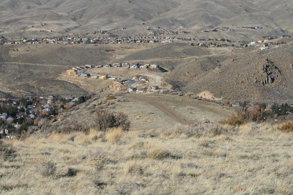
The towers now are mostly gone, having been salvaged for scrap along the way, but a surprising number of the accompanying concrete arrows have survived. This one is on the western edge of Reno, Nevada, in an undeveloped part of a public park just south of Interstate 80.

Related Tags

Navigation Geographic Markers Aircraft Mail

Know Before You Go

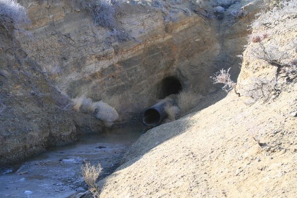
The arrow can only be reached on foot or mountain bike as motorized traffic in the park is prohibited. From Mayberry Park in west suburban Reno take the Hole-in-the-Wall trail. This climbs up the slope south of the park and follows the Steamboat Ditch, a prominent irrigation ditch, west to a tunnel--the "Hole in the Wall"--under a ridge (see picture). From there take the obvious steep road up to the top of the ridge and then follow the ridge right (north). The arrow is at the end of the ridge where it drops off steeply

Community Contributors

Added By

slgwv

Published

January 26, 2022

Edit this listing

Make an Edit
Add Photos
Sources
  • https://sometimes-interesting.com/concrete-arrows-and-the-u-s-airmail-beacon-system/ https://www.atlasobscura.com/articles/before-radios-pilots-navigated-by-giant-concrete-arrows
Airmail Arrow
Reno, Nevada
United States
39.51212, -119.919312
Visit Website

Nearby Places

Hunter Creek Falls

Reno, Nevada

miles away

Von Schmidt Monument

Verdi, Nevada

miles away

Wilbur D. May Museum

Reno, Nevada

miles away

Explore the Destination Guide

Photo of Reno

Reno

Nevada

Places 13
Stories 1

Nearby Places

Hunter Creek Falls

Reno, Nevada

miles away

Von Schmidt Monument

Verdi, Nevada

miles away

Wilbur D. May Museum

Reno, Nevada

miles away

Explore the Destination Guide

Photo of Reno

Reno

Nevada

Places 13
Stories 1

Related Stories and Lists

Arrows Across America

Podcast

By The Podcast Team

Related Places

  • The arrow, looking back toward arrow #31 by Moapa.

    Mesquite, Nevada

    Airmail Arrow #32 LA-SL

    A concrete arrow from a 1920s airmail navigation network.

  • Looking back at the contemporary installations.

    Moapa Valley, Nevada

    Moapa Airmail Arrow

    A well-preserved example from a 1920s network of airmail navigation arrows sits near Interstate 15 in southern Nevada.

  • Repère Pierre du Niton

    Geneva, Switzerland

    Repère Pierre du Niton

    This stone in Lake Geneva was once the reference point used to determine altitude in Switzerland.

  • El Hierro, Spain

    Monumento Meridiano Cero (Zero Meridian Monument)

    What many consider the original prime meridian and westernmost point of the old world.

  • Center of Edinburgh.

    Edinburgh, Scotland

    'Center of Edinburgh' Bollard

    This mundane post marks the old location of the city's main postal hub.

  • A sign marking the Tropic of Capricorn.

    Namibia

    Tropic of Capricorn Crossing

    Road signs in Namibia mark the location of one of the five major circles of latitude.

  • Green Belt sign in Emsworth.

    Pittsburgh, Pennsylvania

    Allegheny County Belt System

    Color-coded signs direct drivers on a network of routes designed to avoid Pittsburgh traffic.

  • World’s Largest Compass Rose

    Edwards Air Force Base, California

    World's Largest Compass Rose

    Etched into a dry lake bed, this massive directional indicator is accurate without magnets.

Aerial image of Vietnam, displaying the picturesque rice terraces, characterized by their layered, verdant fields.
Atlas Obscura Membership

Become an Atlas Obscura Member


Join our community of curious explorers.

Become a Member

Get Our Email Newsletter

Follow Us

Facebook YouTube TikTok Instagram Pinterest RSS Feed

Get the app

Download the App
Download on the Apple App Store Get it on Google Play
  • All Places
  • Latest Places
  • Most Popular
  • Places to Eat
  • Random
  • Nearby
  • Add a Place
  • Stories
  • Food & Drink
  • Itineraries
  • Lists
  • Video
  • Podcast
  • Newsletters
  • All Trips
  • Family Trip
  • Food & Drink
  • History & Culture
  • Wildlife & Nature
  • FAQ
  • Membership
  • Feedback & Ideas
  • Community Guidelines
  • Product Blog
  • Unique Gifts
  • Work With Us
  • About
  • FAQ
  • Advertise With Us
  • Advertising Guidelines
  • Privacy Policy
  • Cookie Policy
  • Terms of Use
Atlas Obscura

© 2025 Atlas Obscura. All Rights Reserved.