Trips Places Foods Stories Newsletters
Loading...
Loading...
Loading...
Loading...

No search results found for
“”

Make sure words are spelled correctly.

Try searching for a travel destination.

Places near me Random place

Popular Destinations

  • Paris
  • London
  • New York
  • Berlin
  • Rome
  • Los Angeles
Trips Places Foods Stories Newsletters
Sign In Join
Places near me Random place
All Australia Purnululu Bungle Bungle Range
AO Edited

Bungle Bungle Range

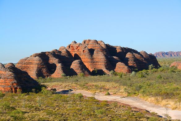
These Australian rock formations look like Martian beehives that have grown up out of the landscape.

Purnululu, Australia

Added By
Sam
Email
Been Here
Want to go
Added to list
CAPTION
Bungle Bungle Range   Baras on Wikipedia
Bungle Bungle Range   Jon Connell on Flickr
Bungle Bungle Range   Peter Ruckstuhl on Wikipedia
Been Here
Want to go
Added to list

About

Rising out of the landscape of the Purnululu National Park, the terrifically named Bungle Bungle Range are beehive-shaped rock formations that are thought to have been caused by the erosion of a very ancient meteorite crater.

The gem of the Purnululu National Park in Western Australia, the geologic range is one of the most impressive stone formations on Earth, and maybe even Mars, which is where they seem to be from. Forming rounded cones and cylindrical towers, the rocks are made of porous conglomerate rock, the texture of which gives them their oft-remarked upon beehive look. The sediment that formed the rocks is thought to have been deposited 350-375 million years ago, slowly eroded from the wind and rains of the surrounding desert. 

The "Bungle Bungles," as they are often called, also have a distinct orange-and-black-ringed pattern running all down their surface. This is caused not only by the conglomerate nature of their make-up but from water getting trapped in denser layers, allowing algae to grow and form the darker colorations.   

The rocks have long been an important site of the Jaru and Gidja peoples, who've lived in the region for between 20,000 and 40,000 years. The rocks were only "discovered" by outsiders in 1983 and they became a UNESCO World Heritage site in 2003. Today, the rocks are still a fascinating feature, though their remoteness prevents them from being too overwhelmed with tourists.

Related Tags

Rocks Geology Geological Oddities

Know Before You Go

Access to the park by road is via Spring Creek Track, from the Great Northern Highway approximately 250 km (160 mi) south of Kununurra, to the track's end at the visitor centre. The track is 53 km (33 mi) long and is usable only in the dry season (about 1 April to 31 December), and only by four-wheel-drive (4WD) vehicles.

Community Contributors

Added By

SamM

Edited By

charlesdberger, EricGrundhauser

  • charlesdberger
  • EricGrundhauser

Published

December 18, 2015

Edit this listing

Make an Edit
Add Photos
Sources
  • http://parks.dpaw.wa.gov.au/park/purnululu
  • http://whc.unesco.org/en/list/1094
  • http://www.australia.com/en-us/places/kimberley/wa-purnululu-national-park.html
  • http://www.kimberleyaustralia.com/bungle-bungles.html
  • http://www.australiasnorthwest.com/Destinations/The_Kimberley/Purnululu_National_Park_and_the_Bungle_Bungles
Bungle Bungle Range
Purnululu National Park
Purnululu, 6770
Australia
-17.529752, 128.400838
Get Directions

Explore the Destination Guide

Photo of Australia

Australia

Oceania

Places 610
Stories 94

Explore the Destination Guide

Photo of Australia

Australia

Oceania

Places 610
Stories 94

Related Places

  • Colorful sandstone cliff just west of the Colorock Quarry.

    Moapa Valley, Nevada

    Buffington Pockets

    The rocks exposed at Valley of Fire State Park also occur in a much less known but equally spectacular area a few miles to the southwest.

  • Fluorescent Andersonite from Utah.

    Tempe, Arizona

    Miners Rock Shop

    A family-owned store specializing in minerals, geodes, gemstones, and more.

  • Grampian, Pennsylvania

    Bilger's Rocks

    Rocky outcrops containing overhangs, caves, fissures, clefts, and alcoves that invite exploration and scrambling.

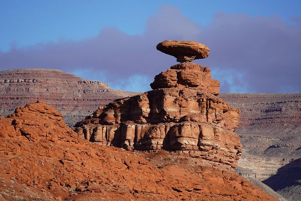
  • Mexican Hat

    Mexican Hat, Utah

    Mexican Hat

    This balancing rock is one of Utah's most unusual geological formations.

  • Mortana, Australia

    Murphy’s Haystacks

    These oddly shaped pink granite formations got their name after being mistaken for massive piles of hay.

  • Edmaier’s Secret

    Big Water, Utah

    Edmaier's Secret

    This hidden gem in Arizona is truly worth the rugged journey.

  • Mina de Mármol

    Cuatrociénegas, Mexico

    Mina de Mármol

    A former travertine mine traces the geological history of this unique desert filled with crystalline blue pools.

  • Brady’s Rocks are the southernmost surface exposure of the massive Niagara Escarpment.

    Eagle, Wisconsin

    Brady's Rocks

    These modest Midwestern formations are kin to Niagara Falls' impressive cliffs, more than 600 miles away.

Aerial image of Vietnam, displaying the picturesque rice terraces, characterized by their layered, verdant fields.
Atlas Obscura Membership

Become an Atlas Obscura Member


Join our community of curious explorers.

Become a Member

Get Our Email Newsletter

Follow Us

Facebook YouTube TikTok Instagram Pinterest RSS Feed

Get the app

Download the App
Download on the Apple App Store Get it on Google Play
  • All Places
  • Latest Places
  • Most Popular
  • Places to Eat
  • Random
  • Nearby
  • Add a Place
  • Stories
  • Food & Drink
  • Itineraries
  • Lists
  • Video
  • Podcast
  • Newsletters
  • All Trips
  • Family Trip
  • Food & Drink
  • History & Culture
  • Wildlife & Nature
  • FAQ
  • Membership
  • Feedback & Ideas
  • Community Guidelines
  • Product Blog
  • Unique Gifts
  • Work With Us
  • About
  • FAQ
  • Advertise With Us
  • Advertising Guidelines
  • Privacy Policy
  • Cookie Policy
  • Terms of Use
Atlas Obscura

© 2025 Atlas Obscura. All Rights Reserved.