Clocha na hÉireann (Stones of Ireland)
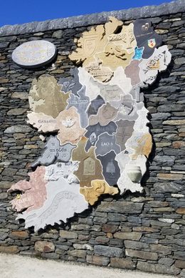
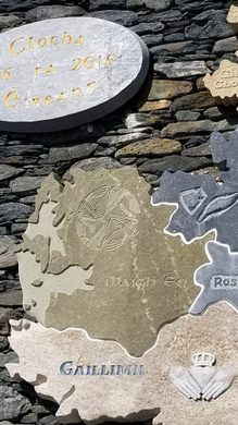
A map made up of 32 different materials, representing Ireland's 32 counties.


Since 2014, residents of County Donegal, Ireland, have mounted a remarkable annual gathering: the Tír Chonaill Stone Festival. Founders imagined it as a way of celebrating and continuing traditional stone skills such as dry stone walling and stone carving. Festival attendees leave behind a legacy of stonemasonry, created on site as part of the weekend’s activities, usually taking the form of newly constructed or repaired stone walls and public art pieces. The festival has been held in a variety of locations in the county, but one memorable year saw the creation of a one-of-a-kind work of art.
In 2016, organizers had the idea to do something special to commemorate the 100th anniversary of the 1916 Easter Rising, which led ultimately to the establishment of the Irish Republic. They decided on a collaborative sculpture that would be installed at the site of that year’s gathering, the remote coastal village of Glencolumbkille. Their goal was to create a map of Ireland, with each county represented by its own local stone, carved by a stonemason from each county. Each stone was to be three inches (75 mm) thick; power tools could be used for roughing out but the finished surface had to be hand cut. The county name was to be carved in the Irish language with Irish script, and carvers could add motifs with a direct relationship to their counties.
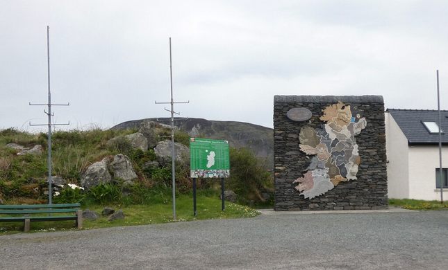
The organizers came up with many ingenious ways to make the plan as foolproof as possible, but it was still a gamble; what if the individual pieces of the puzzle didn’t come together? Well, when the pieces were all gathered and dry fit, everyone heaved an enormous sigh of relief. A beautiful base had been constructed on which the pieces were to be mounted—a work of art in itself, gorgeous local schist covering a concrete base. Everything had come together as had been planned, yet each individual piece displayed the stamp of its local area, in differing stone, decoration, and carving style. The result is remarkable, and stands today as a testament to what can be accomplished when clever and talented craftspeople unite around a common purpose.
The Stones of Ireland map is on permanent display in the village of Glencolumbkille, opposite the entrance to the Glencolumbkille Folk Village, a living history museum that tells the story of the challenges of rural life in this remote corner of Ireland.


Follow us on Twitter to get the latest on the world's hidden wonders.
Like us on Facebook to get the latest on the world's hidden wonders.
Follow us on Twitter Like us on Facebook