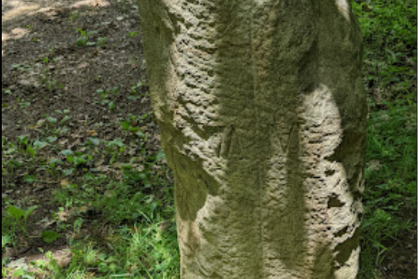
Trips Places Foods Stories Newsletters
Loading...
Loading...
Loading...
Loading...

No search results found for
“”

Make sure words are spelled correctly.

Try searching for a travel destination.

Places near me Random place

Popular Destinations

  • Paris
  • London
  • New York
  • Berlin
  • Rome
  • Los Angeles
Trips Places Foods Stories Newsletters
Sign In Join
Places near me Random place
All the United Kingdom England Moreton-in-Marsh Four Shire Stone

Four Shire Stone

The centuries-old obelisk may have inspired J. R. R. Tolkien.

Moreton-in-Marsh, England

Added By
punkin
Email
Been Here
Want to go
Added to list
CAPTION
Four Shire Stone.   Michael Dibb
Four Shire Stone.   August Schwerdfeger
Four-Shire Stone map.   By George Philip (1800-1882) or his son George Philip (1823-1902) Own work, Public Domain
Been Here
Want to go
Added to list

About

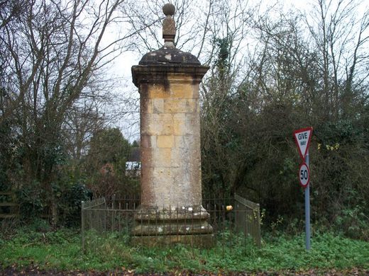
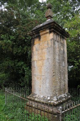
This weathered obelisk stands before a stretch of greenery alongside a highway, frequently overlooked by passing motorists. It looks obsolete, much like the geographic purpose it once served.

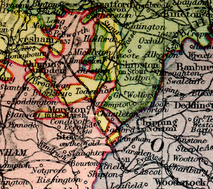
A monument has stood on the site since 1675. This particular version was installed in the 1700s and is considered a historic building. For centuries, it marked the spot where four of England's shires (Warwickshire, Gloucestershire, Worcestershire, and Oxfordshire) touched. As such, it became known as the Four Shire Stone.

However, in the 20th century, some geographic shuffling demoted the marker from a four shire stone to a three shire stone. Because Worcestershire’s boundaries were changed, circling the stone will no longer take you through a brief journey through that shire.

Supposedly, the Four Shire Stone inspired none other than J. R. R. Tolkien himself. In both The Hobbit and The Lord of the Rings, the Shire is divided into four farthings, three of which meet at the Three-Farthing Stone. Many say the famous author drew inspiration from this very obelisk.

Related Tags

Geographic Markers Monuments Tolkien

Community Contributors

Added By

punkin

Edited By

oscarley07, Kerry Wolfe

  • oscarley07
  • Kerry Wolfe

Published

February 7, 2018

Edit this listing

Make an Edit
Add Photos
Sources
  • https://en.wikipedia.org/wiki/Four_shire_stone
  • http://tolkiengateway.net/wiki/Four_Shire_Stone
  • http://www.hunimex.com/warwick/four_shire_stone.html
  • https://historicengland.org.uk/listing/the-list/list-entry/1303562
  • Maps by JRR+Cristopher Tolkien
  • The Hobbit by JRR Tolkien
  • The Lord of the Rings 1,2,3 by JRR Tolkien
Four Shire Stone
A44
Moreton-in-Marsh, England
United Kingdom
51.987516, -1.665816
Get Directions

Nearby Places

Chastleton House Croquet Lawn

Chastleton, England

miles away

Sezincote Estate

Gloucestershire, England

miles away

The Tures

Stow-on-the-Wold, England

miles away

Explore the Destination Guide

Photo of England

England

United Kingdom

Places 2,199
Stories 144

Nearby Places

Chastleton House Croquet Lawn

Chastleton, England

miles away

Sezincote Estate

Gloucestershire, England

miles away

The Tures

Stow-on-the-Wold, England

miles away

Explore the Destination Guide

Photo of England

England

United Kingdom

Places 2,199
Stories 144

Related Places

  • Écaussinnes, Belgium

    ‘Bonhomme de Fer’ (‘The Iron Man’)

    This human-shaped statue is actually a geodesic station.

  • Tri-States Monument and Delaware River

    Port Jervis, New York

    Tri-States Monument

    A pair of 19th-century granite markers symbolically record where the state boundaries of New York, New Jersey, and Pennsylvania intersect.

  • 49th Parallel North Monument in Prešov, Slovakia

    Prešov, Slovakia

    49th Parallel North Monument

    A quirky monument to the 49th parallel in downtown Prešov, Slovakia.

  • Monument to the geographic center of Belgium

    Walhain, Belgium

    Geographic Center of Belgium

    This metal monument marking the middle of Belgium represents three regions coming together to form one country.

  • Leuven, Belgium

    Middelpunt van Leuven

    This unassuming stone bollard is a centuries-old marker denoting the center of the city.

  • Buggenhout, Belgium

    Middelpunt van Vlaanderen

    The geographic midpoint of the Dutch-speaking part of Belgium.

  • Markleysburg, Pennsylvania

    Old Tri-State Monument

    This original Mason-Dixon line cairn placed in the 1760s was put in the wrong location because of the gravitational pull of the Allegheny Mountains.

  • Ras Angela

    Ras Angela, Tunisia

    Ras Angela

    The northernmost point of continental Africa—or is it?

Aerial image of Vietnam, displaying the picturesque rice terraces, characterized by their layered, verdant fields.
Atlas Obscura Membership

Become an Atlas Obscura Member


Join our community of curious explorers.

Become a Member

Get Our Email Newsletter

Follow Us

Facebook YouTube TikTok Instagram Pinterest RSS Feed

Get the app

Download the App
Download on the Apple App Store Get it on Google Play
  • All Places
  • Latest Places
  • Most Popular
  • Places to Eat
  • Random
  • Nearby
  • Add a Place
  • Stories
  • Food & Drink
  • Itineraries
  • Lists
  • Video
  • Podcast
  • Newsletters
  • All Trips
  • Family Trip
  • Food & Drink
  • History & Culture
  • Wildlife & Nature
  • FAQ
  • Membership
  • Feedback & Ideas
  • Community Guidelines
  • Product Blog
  • Unique Gifts
  • Work With Us
  • About
  • FAQ
  • Advertise With Us
  • Advertising Guidelines
  • Privacy Policy
  • Cookie Policy
  • Terms of Use
Atlas Obscura

© 2025 Atlas Obscura. All Rights Reserved.