About
A series of thrashing rapids form a frothy, frenzied line along a beautiful stretch of water. The violent ripples are the water’s way of protesting the ever-changing direction of the tides.
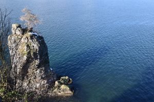
The Skookumchuck Narrows are a strait at the entrance of the Sechelt Inlet, in the Skookumchuck Narrows Provincial Park. Its unique location means it is strongly affected by tides. Twice daily, the direction of its flow completely reverses, and the rocky terrain near the shore gives rise to a dramatic watery spectacle that includes what some say are the fastest tidal rapids in the world.
As the salty water swaps directions, the currents clash and whip up a fury of swirling whirlpools and rapids. Every day, more than two hundred billion gallons of water is forced through the inlet, contributing to the strong rapids. Height differences from one end of the rapids to the other can reach nine feet, and the water can churn at speeds of nearly 20 miles per hour. Daring kayakers occasionally take advantage of the large swells.
The hike to reach the Narrows is West Coast scenic. To view the rapids, you first have to trek through lush vegetation along a trail that, while well maintained, will have you clambering over thick roots or rocks from time to time.
Related Tags
Know Before You Go
There are two locations that offer ideal views of the Narrows: North Point and Roland Point. North Point is located atop a small bluff, with a wide vista of the inlet below. Roland Point (where the GPS coordinates lead) is located at the water line, and gives the best views of the intense rapids. Be careful if stepping out onto the smooth rocks along the water's edge.
Generally accessible only by vehicle. Head towards Earl's Cove at the northern tip of the Sunshine Coast (which itself is accessible via a passenger-and-vehicle ferry from Horseshoe Bay, north of Vancouver). Just before Earl's Cove turn right toward Egmont.
There is a roadside parking lot across from the Egmont Heritage Centre, with public parking intended for the Narrows. The trail begins at the lot, and connects with Doriston Highway. Follow the road past a local bakery (an excellent stop before the hike proper). Note that Doriston has no parking and leads only the park, and to private property. Be courteous of residents. Follow the road to reach the park, and the narrows.
A large sign near the entrance of the park informs visitors of current park status, and ideal times to visit the narrows based on recent activity.
Published
February 2, 2018