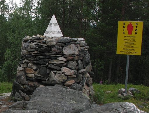
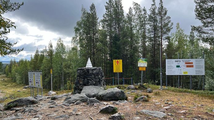
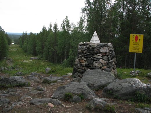
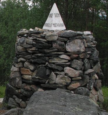
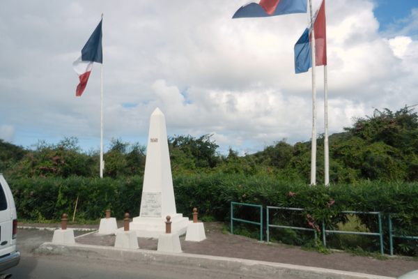
Trips Places Foods Stories Newsletters
Loading...
Loading...
Loading...
Loading...

No search results found for
“”

Make sure words are spelled correctly.

Try searching for a travel destination.

Places near me Random place

Popular Destinations

  • Paris
  • London
  • New York
  • Berlin
  • Rome
  • Los Angeles
Trips Places Foods Stories Newsletters
Sign In Join
Places near me Random place
All Finland Inari Treriksrøysa

Treriksrøysa

This cairn marks the only place where Central European Time, Eastern European Time, and Further-eastern European Time meet.

Inari, Finland

Added By
CoolCrab
Email
Been Here
Want to go
Added to list
CAPTION
Muotkavaara.   Julia Velkova/cc by 2.0
Border zone sign.   Julia Velkova/cc by 2.0
The border crossing from the Finnish side.   Julia Velkova/cc by 2.0
Been Here
Want to go
Added to list

About

In most places, if you cross a time zone border, you’ll only go one hour forward or backward. But at this tri-country border, you can leap forward or backward two hours, depending on which border you cross.

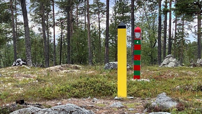
This strange construction happens because of Norway’s hook-like shape. Some of the country’s northern end touches both Finland and Russia. The point where Norway meets Finland and Russia is not only a three-country point, but also a place where time gets weird. It's the only place where Central European Time, Eastern European Time, and Further-eastern European Time meet.

When Norway follows Central European Standard Time, it’s GMT +1. During this part of the year, Finland is GMT +2, and this part of Russia is GMT +3. Just walking around this point and stepping into the countries will put you in a whirlwind of time zones.

Treriksrøysa is a cairn that marks the spot where the three countries meet. It's been there since 1846, with a concrete tetrahedron showing each country’s name added in 1945.

Related Tags

Borders Border Crossings Geographic Markers Time

Know Before You Go

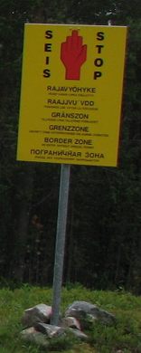
The tripoint is most easily reached from Grensefoss on the Norwegian side, around a three-mile hike each way. The point is free to access and you can cross into Finland, but do watch out with going into Russia without a visa.

Community Contributors

Added By

CoolCrab

Edited By

groenpluisje

  • groenpluisje

Published

April 18, 2019

Edit this listing

Make an Edit
Add Photos
Sources
  • https://en.wikipedia.org/wiki/Muotkavaara
  • https://en.wikipedia.org/wiki/Treriksr%C3%B8ysa
Treriksrøysa
Inari, 99860
Finland
69.051692, 28.92579

Nearby Places

Pielpajärvi Wilderness Church

Inari, Finland

miles away

Kola Superdeep Borehole

Murmansk, Russia

miles away

Siida Museum

Inari, Finland

miles away

Explore the Destination Guide

Photo of Inari

Inari

Finland

Places 3

Nearby Places

Pielpajärvi Wilderness Church

Inari, Finland

miles away

Kola Superdeep Borehole

Murmansk, Russia

miles away

Siida Museum

Inari, Finland

miles away

Explore the Destination Guide

Photo of Inari

Inari

Finland

Places 3

Related Stories and Lists

15 Places Where Borders Get a Little Strange

List

By Jonathan Carey

Related Places

  • Concordia Monument

    Belvedere, Sint Maarten

    Concordia Monument

    Where Saint-Martin ends and Sint Maarten begins (or vice versa).

  • Semināra iela/Sepa tänav border.

    Valga, Estonia

    Valga/Valka Border

    For the last century, this international border within a small town has appeared and disappeared various times.

  • Outside crossing when there is no snow.

    Rovaniemi, Finland

    Rovaniemi's Arctic Circle Border

    If you visit Santa's village, you can get your passport stamped to show you crossed into the Arctic Circle.

  • Doi Tung trenches.

    Tambon Pong Ngam, Thailand

    Doi Tung Trenches

    The Thai Army has dug deep trenches along the Thai/Myanmar border to prevent drug smuggling.

  • Russian post clearly indicating Border Crossing No. 487.

    Teshig, Mongolia

    Mongolia/Russia Border Crossing No. 487

    This extremely remote border crossing was closed to prevent smuggling and looting.

  • Mason-Dixon survey stone.

    Delmar, Maryland

    Transpeninsular Midpoint Marker

    The stone marker that Mason and Dixon placed at the eastern end of the famous north-south border they surveyed.

  • The cross site at the peak of Mt. Sorgschrofen, viewed from below

    Pfronten, Germany

    The Jungholz Quadripoint

    Two nations form a rare four-sided border at the peak of a mountain, philosophical questions result.

  • Tri-States Monument and Delaware River

    Port Jervis, New York

    Tri-States Monument

    A pair of 19th-century granite markers symbolically record where the state boundaries of New York, New Jersey, and Pennsylvania intersect.

Aerial image of Vietnam, displaying the picturesque rice terraces, characterized by their layered, verdant fields.
Atlas Obscura Membership

Become an Atlas Obscura Member


Join our community of curious explorers.

Become a Member

Get Our Email Newsletter

Follow Us

Facebook YouTube TikTok Instagram Pinterest RSS Feed

Get the app

Download the App
Download on the Apple App Store Get it on Google Play
  • All Places
  • Latest Places
  • Most Popular
  • Places to Eat
  • Random
  • Nearby
  • Add a Place
  • Stories
  • Food & Drink
  • Itineraries
  • Lists
  • Video
  • Podcast
  • Newsletters
  • All Trips
  • Family Trip
  • Food & Drink
  • History & Culture
  • Wildlife & Nature
  • FAQ
  • Membership
  • Feedback & Ideas
  • Community Guidelines
  • Product Blog
  • Unique Gifts
  • Work With Us
  • About
  • FAQ
  • Advertise With Us
  • Advertising Guidelines
  • Privacy Policy
  • Cookie Policy
  • Terms of Use
Atlas Obscura

© 2025 Atlas Obscura. All Rights Reserved.