Climate Change Is Coming for America’s National Parks
Goodbye, glaciers.
Lisa McKeon remembers the moment it happened. She was eating a bagel with cream cheese when she heard it: a thundering crack, followed by a splash. The sound reverberated off the basin’s walls of sedimentary rock.
McKeon is a physical scientist at the U.S. Geological Survey’s Northern Rocky Mountain Science Center (NOROCK), stationed in West Glacier, Montana. She spends a lot of time in the field in Glacier National Park. That afternoon last month, though, she was off the clock—picnicking with her 13-year-old daughter on the smooth rocks 50 yards from the shore of Upper Grinnell Lake, a body of meltwater at the terminus of Grinnell Glacier. “I wanted to bring her to a place I have been going to since I was her age,” McKeon says.
McKeon goes out to Grinnell a few times a year, and some things never seem to change. It’s always cold there—enough so that, when the wind whips off the ice, carrying the smell of wet dirt, she has to pull on every layer of clothing she stuffed into her backpack, no matter the season. The ice, embedded with little pebbles and bits of rock, always pops underfoot when she gets up close to measure Grinnell’s margins. The glacier itself is always loud. While these ice giants may look static, active glaciers are perpetually on the move. They creak and moan; inside, water courses through rivulets and tunnels. These can be so deep in the ice that they seem invisible—still, you can hear the rushing.
But in all her time around glaciers, McKeon had never heard a sound like this. Even so, “I knew exactly what was happening,” she says. The glacier was calving.
She didn’t see the fracture, but when she heard the inescapable, unmistakable sound, McKeon turned her gaze to the water. “You couldn’t see any waves across the top, but [the water level] started rising,” she says. “Icebergs were sloshing back and forth.”

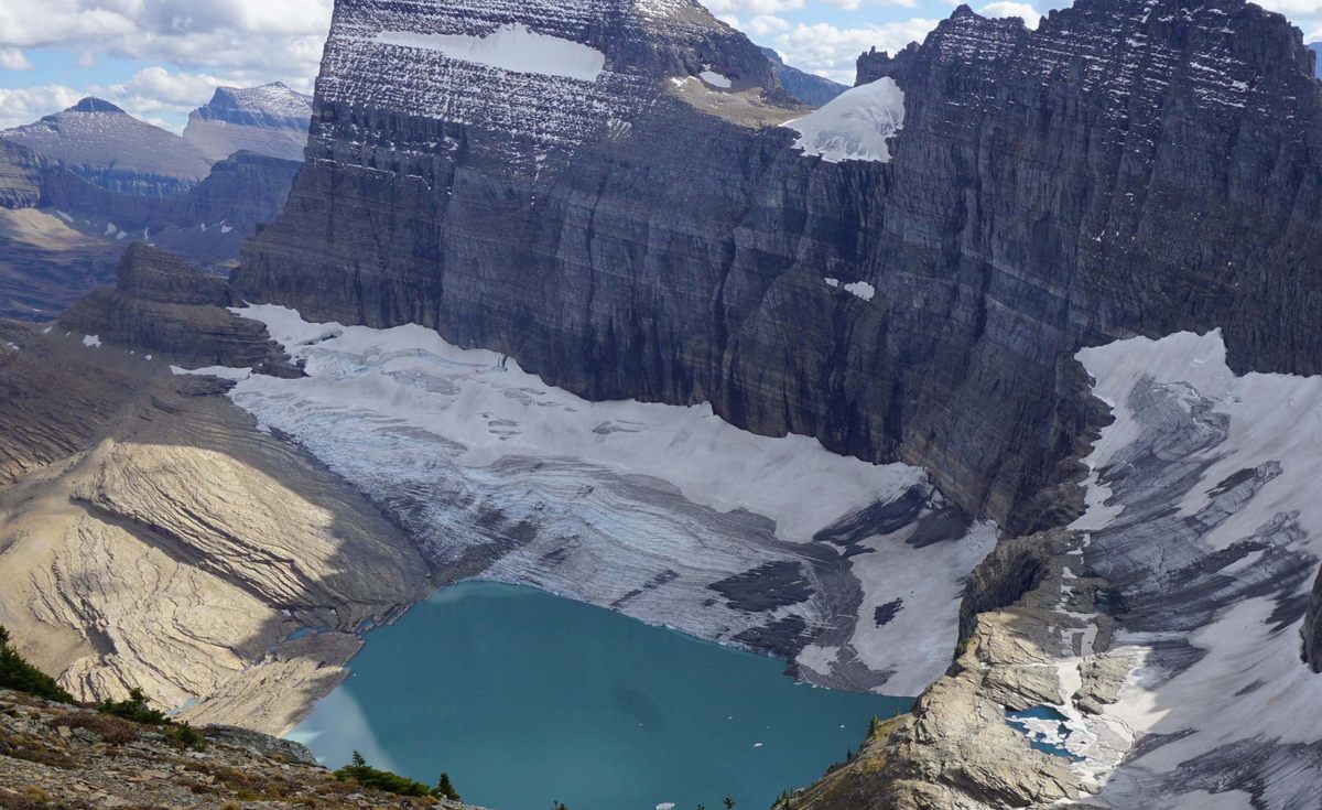
Glaciers calve—it’s part of their natural life cycle—but in a warming world, it is happening more often. In July, a tremendous iceberg separated from a glacier near Greenland’s west coast and bobbed over to Innaarsuit. Residents evacuated the small fishing village as more than 10 million tons of ice loomed just offshore. The behemoth was a harbinger. “As things continue to warm up, more ice is gonna come off and float around,” Joshua Willis, a glaciologist from NASA’s Jet Propulsion Lab, told The New Yorker at the time.
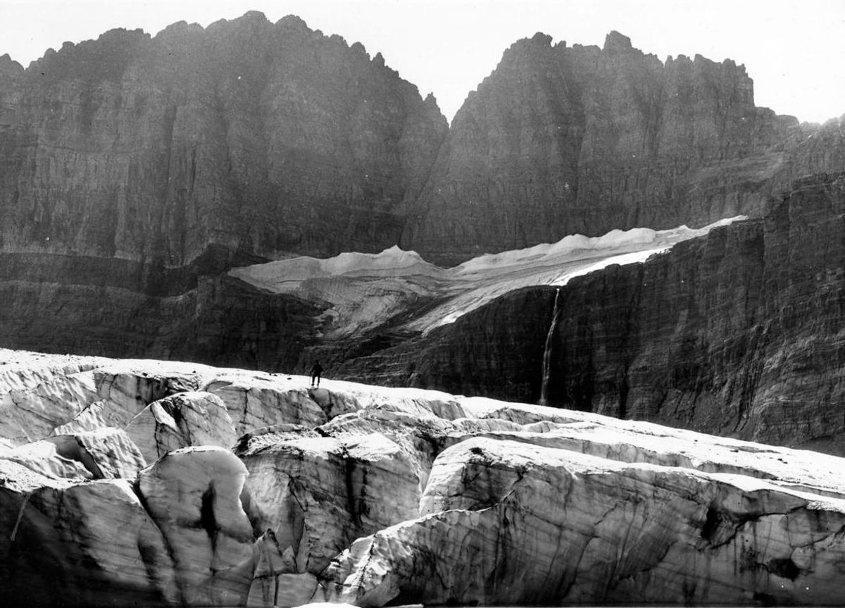
In addition to that falling ice, glaciers are losing bulk to melt, too. It’s already happening at Grinnell. In one picture from 1938, the glacier is so huge and richly marbled that it’s easy to miss the person standing atop it. (The first hint is two tiny, dark shoes against the large expanse of white.) By 2016, there was nothing left to summit—where the figure had stood, the ice had given way to water.
That is the other thing that now stays the same at Grinnell, year after year—loss. Climate change is coming for glaciers, and the national parks as a whole. It’s coming fast. We can’t shield all of these protected areas from the future we have given them. So then what? What’s Glacier National Park without its famous ice?
The iconic landscapes of America’s national parks occupy potent places in the cultural imagination—and they can make for stunning demonstrations of the impacts of climate change. That’s not only because the parks are so familiar, but also because, compared to the rest of the country, they are being hit particularly hard.
That’s the thrust of a new paper from researchers at the University of California, Berkeley, and the University of Wisconsin-Madison. In the journal Environmental Research Letters, the authors report the results of the first survey measuring both historical temperatures and rainfall across all 417 sites in the system—parks, battlefields, monuments, and more—alongside projections for future changes under various emissions forecasts. The researchers found that, between 1895 and 2010, the land within the parks has warmed at double the rate of the rest of the country. Meanwhile, precipitation in the parks has decreased by 12 percent, as opposed to the 3 percent average across the rest of the United States.
Some difference between the parks and the rest of the country isn’t entirely surprising, because so much of the parks’ total area is baldly exposed, at high elevations or northern climes, where warming occurs most dramatically. (Sixty-three percent of total national park area is in Alaska; 19 percent is above the Arctic Circle.) As snow melts, the landscape it once blanketed loses its reflective properties, and absorbs more heat. Even if the pattern was predictable, “the magnitude of the difference was not expected,” says lead author Patrick Gonzalez, a forest ecologist at Berkeley.
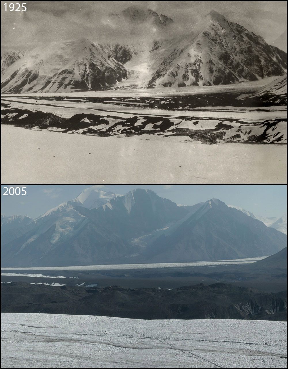
In the years between 1950 and 2010, Denali National Park and Preserve, in Alaska, warmed most of all. The authors report that Denali’s temperatures rose by 4.3°C over the last few decades, which squares fairly neatly with the National Park Service’s own measurement of 4°C.
The authors project that curbing greenhouse gas emissions could cushion future blows. “Cutting emissions can save parks from the most extreme heat,” Gonzalez says, but under any reduction scenario the team modeled, more than half of the total national park area would still experience warming above 2°C, the limit imposed by the Paris Agreement (of which the United States may soon no longer be a party).
Cutting emissions is a mitigation tactic—ultimately cheaper and more straightforward, Gonzalez says, than cleaning up a mess once it’s made. At a local level, parks are chipping in to cap emissions: Joshua Tree, in the Mojave Desert, doubled down on energy-efficient lights and air conditioning, and prohibits cars from idling. The roof of Alcatraz is now covered with solar panels, which offset the diesel needed to run the island’s generators, as well as emissions from boats that haul visitors, supplies, and waste.
Beyond this, the parks will need to adapt, too. They ought to be “managed for potential future conditions, rather than keeping them as vignettes as the past,” Gonzalez says, which was once the prevailing management mentality. “Right now,” he adds, “fire managers use an estimate of what the forests looked like before European settlement, and [are] essentially trying to get the forest to look as it did long ago.” The effects of climate change, he adds, have already made this impossible. “We can’t go back.”
Adaptations vary by ecosystem, but may include building corridors to help species migrate north or uphill—or even, in certain circumstances, manually moving plants and animals if they can’t do it themselves fast enough, says John (Jack) Williams, a study coauthor and geographer at the Center for Climatic Research at the University of Wisconsin-Madison. “The other big thing you can do is preserve microhabitats or microclimates—pockets of favorable climates that could locally help preserve the species,” Williams says. This might include planting more trees to keep a river, and the fish in it, shaded and cool.

Cameron Barrows, a research ecologist at University of California, Riverside’s Center for Conservation Biology, has spent years searching for these refugia in Joshua Tree National Park, for example. There, he worries that temperatures will soon soar higher than young trees that give the park its name can manage: In one model, Barrows and a colleague predicted that a rise of 3°C would shrink the species’ range by 90 percent. Barrows looks for sites in the park where Joshua trees have managed to grow and produce viable saplings, even in drought-stricken years.
Trouble is, Barrows has found that these areas are also favorable to invasive grasses. And when lightning strikes, these grasses go up like tinder, and spread fire from tree to tree. Getting those grasses out of the way is the key to allowing “the refugia to act like a refugia and protect this species,” Barrows says. He’s proposed a slew of ideas, including recruiting a hungry goat to munch on the invasives, deploying a grass-specific herbicide, and building fire lanes to hem in blazes. “Doing nothing is not an option, as far as I’m concerned,” Barrows says.
Heroic interventions aside, it might already be too late for glaciers.
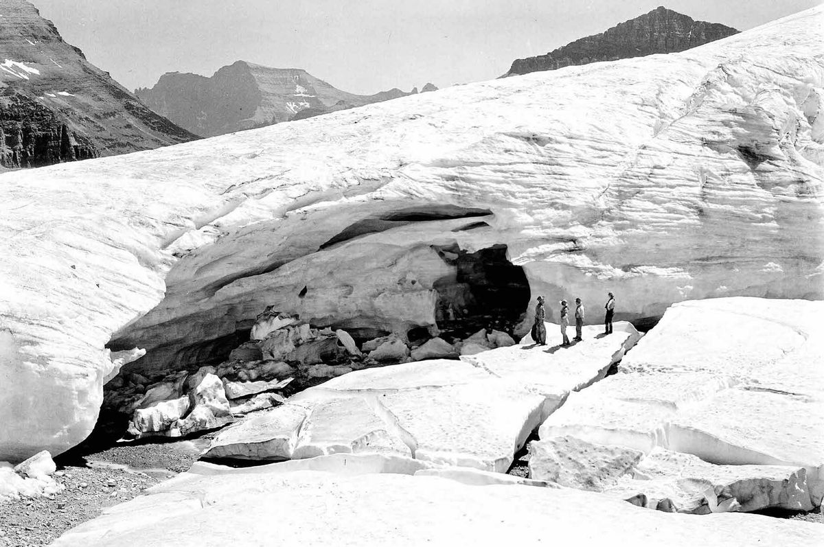
In the summer of 1997, a ranger named Jerry DeSanto walked into the USGS field office with a befuddling pair of images of Boulder Glacier.
In the older of these pictures, taken in 1932, the landscape is capped with snow and ice. A yawning, frozen cave dwarfs the four figures who stand at its mouth. When DeSanto went to photograph the spot again, from a similar vantage point, he found a very different scene. From where he stood, the ice had vanished.

Aerial measurements quantified the change; the glacier’s overall area had shrunk by roughly 78 percent since 1966. Soon, scientists—including McKeon—were digging up other old photographs in the archives and then trekking around the park, snapping contemporary photos in the same places.
Gauging the difference between past and present has been the goal of a similar photography project at Denali. This one launched in 2005, when the park received a trove of hundreds of images from Fred Dean, a former professor of wildlife biology at the University of Alaska Fairbanks who had taken the dutifully annotated photographs in the 1970s, while he was mapping the region. Staffers began trawling archives for other historical images. Other geologists have since shared their own, and park staff captured contemporary scenes on foot, from windows, or up in helicopters. “Many repeated images of glaciers in Denali reveal a consistent theme,” the project staff writes: “Shrinking and retreat of glacial ice and permanent snow fields.”
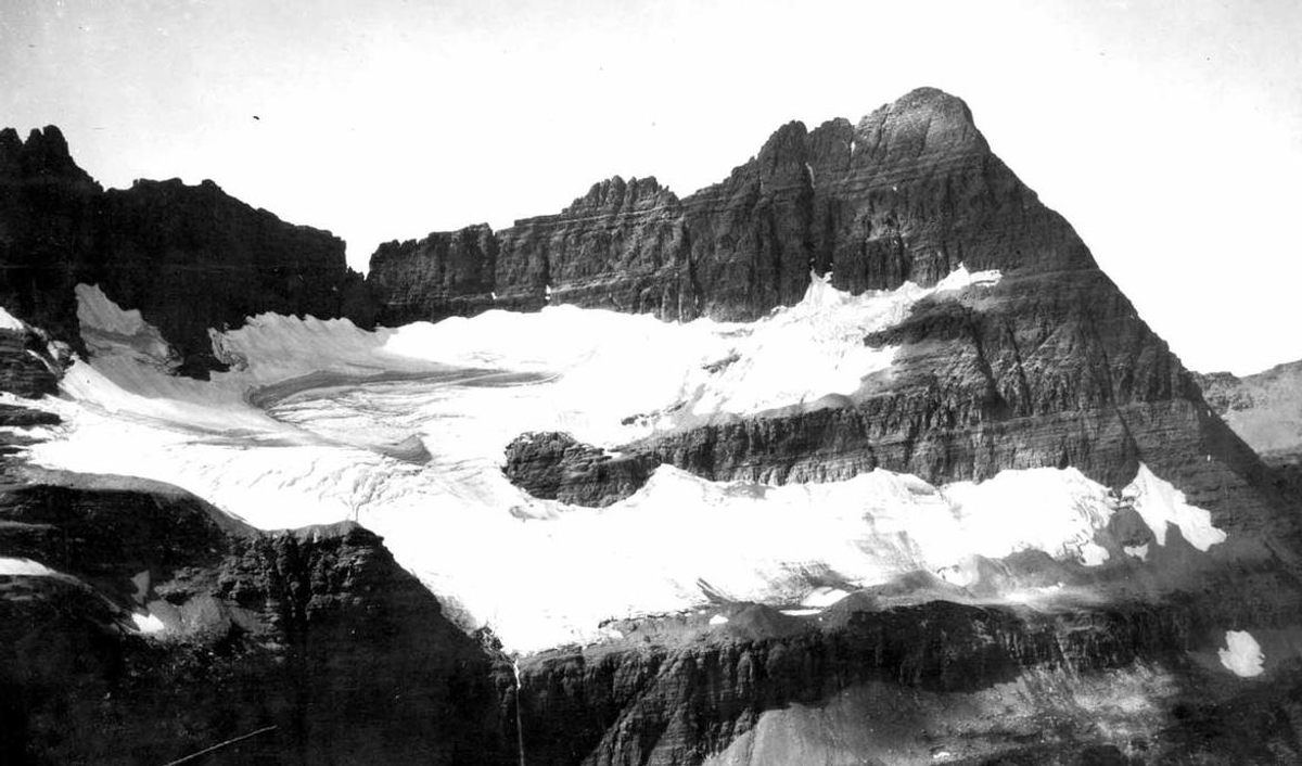
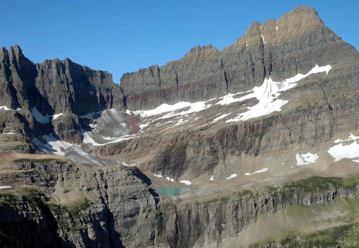
So far, staffers working on NOROCK’s repeat photography project have recreated more than 80 scenes on roughly 20 glaciers. “We’ve gotten to all of the easy ones, basically,” says McKeon. Grinnell, which is accessible via trails, falls into this category. But in this region, nothing is ever easy.
The early photographers rarely annotated their images as Dean had, so it can be hard to retrace their paths, even with the help of Google Earth and careful attention to the horizon and recognizable features such as boulders. McKeon can’t get into the field until mid-to-late August, when the seasonal snow has vanished, exposing the more enduring freeze beneath it. But that’s also the season when wildfires char portions of the park, and those blazes can stymie the photography project, too, by obscuring views with smoke and making portions of the park unreachable. Going around a fire might stretch a three-day journey into five.
The payoff, though, is an ever-growing batch of before-and-after images. “You put those two images together, you don’t need any words, McKeon says, “anyone can interpret what’s happened.” And it’s not hard to imagine the even-bleaker future, in which the sheets of ice get progressively thinner and sparser, until they disappear entirely.
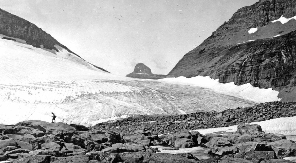
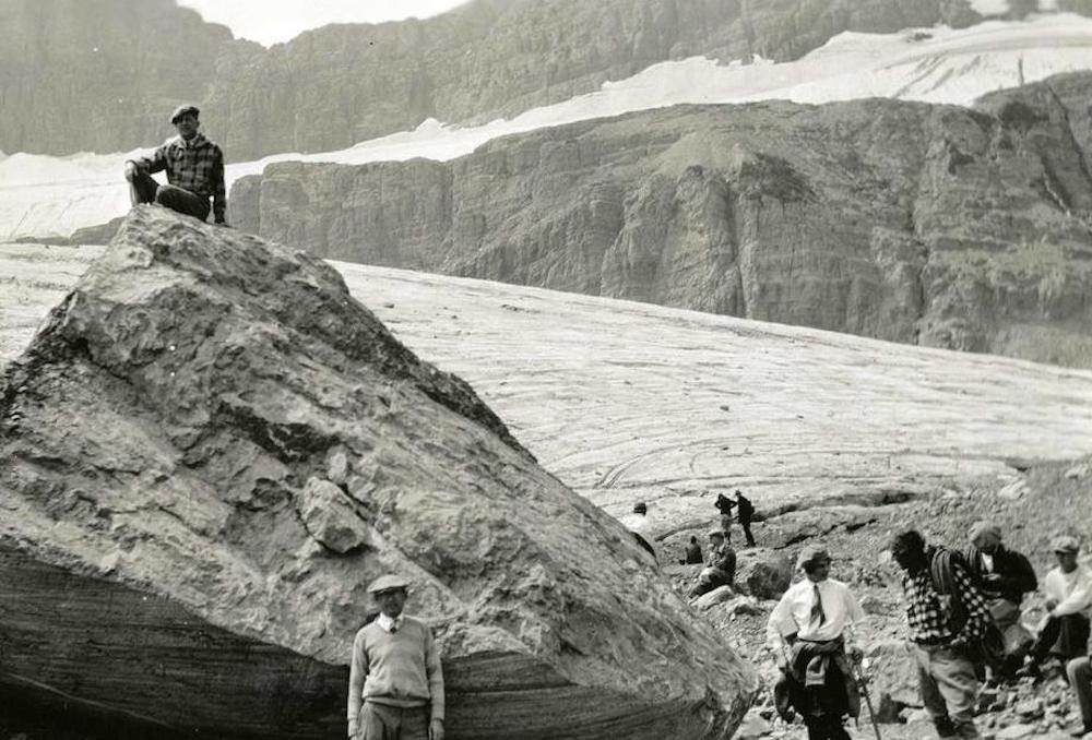
In the 1850s, the land of Glacier National Park was home to 150 of the giant ice flows that would later give the park its name. By many estimates, in the not-especially-distant future, there will be none.
It won’t happen at once. One decades-old model predicted that they’d all be gone by 2030, but now that researchers know more about glacier behavior, McKeon says, the picture is more complicated. Some will go early, others will linger, kept cool by wind or shade. There won’t be a single mass extinction, McKeon says, but the end is near. “All of the glaciers are melting, and the trend is very obvious,” she says. It’s a matter of decades, not centuries.
There’s no good way to extend a glacier’s life. When climate change comes for smaller targets—say, a cultural heritage site—naturalists can sometimes take steps to save them, perhaps by nurturing plants to hold soil in place and buffer an area against a storm surge. Reducing emissions is good, but has diffuse, delayed benefits. Immediate stopgaps have so far produced only so-so results. For years, a group in the Swiss Alps has swaddled the Rhône Glacier in a kind of reflective comforter in an effort to halt the melt. But it’s not a fix—one glaciologist told Agence France-Presse that Rhône still retreats by as many as five centimeters on a balmy day.

Though they weren’t expressly intended to do so, the NOROCK photos may end up being all that is left to keep the glaciers’ legacies alive. Some of them were included in a traveling art exhibition, and with the help of the National Park Service’s interpretive staff, McKeon’s team compiled these photos into a classroom curriculum. McKeon has sent a trunk of the photos all the way to Pennsylvania, Delaware, and Michigan, and down to Florida and California. Surely, some of the Sun Belt kids who study the images will have never seen snow up close. By the time these students have kids of their own, there may be no ancient ice left in Glacier to see.
Even when the glaciers are gone, they’ll leave ghosts. For thousands of years, they have carved out valleys, cirques, and chains of lakes across the Montana landscape, and left behind moraine full of the boulders, pebbles, and silt picked up and deposited along the way. Their fingerprints are all over the place, right in the land itself.
And so, even without its namesake features, “Glacier Park will still be here, and it will still be a wonderful place to visit,” McKeon says. “A glacier-less Glacier Park is still worth ticking off your list.”










Follow us on Twitter to get the latest on the world's hidden wonders.
Like us on Facebook to get the latest on the world's hidden wonders.
Follow us on Twitter Like us on Facebook