This Interactive Sandbox Allows Users to Make Topographical Maps in Real-Time
You can move mountains and make it rain.
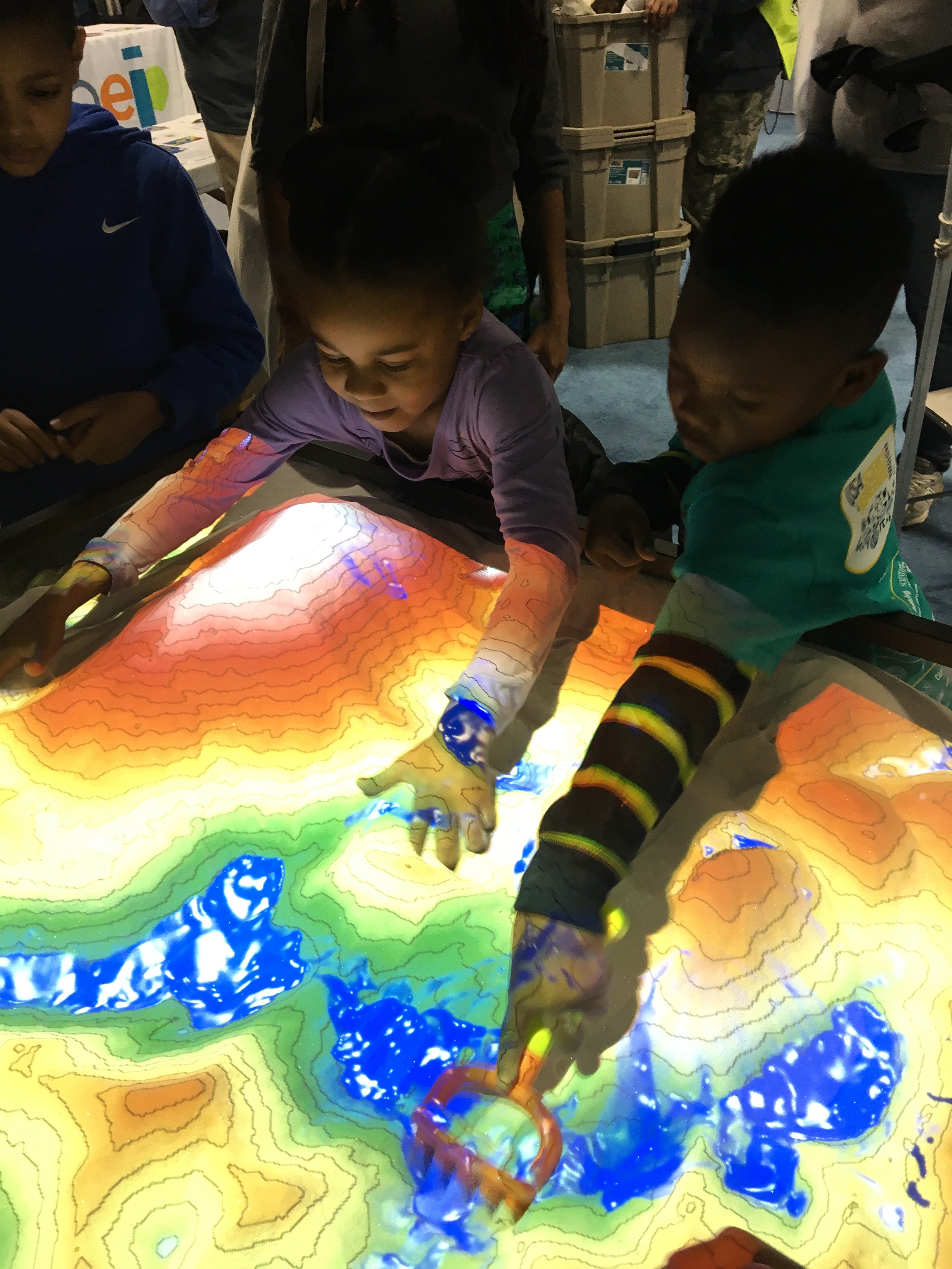
Water moves in predictable ways across undulating landscapes, but it can be hard to appreciate from a human perspective on the ground. It’s much easier to understand when you’re essentially a giant hovering over the land with the ability to move mountains and make rain.
For the unique opportunity to morph landscapes to your liking—a mountain here, a lake there—see the Augmented Reality Sandbox. As users shift around piles of sand, a colorful elevation map projects over the surface. Different shades of red, yellow, and green show the steep or gradual slopes on the land. When a user hovers their hand over the sand, shimmering blue virtual water appears and starts to flow.
In a way, the visualization shows you what you already know: This pile of sand is the tallest and this hole is the deepest. But when watching the display in action, there’s a lot more to glean about the dynamism of topography and how it interacts with flowing water.
The sandbox was originally developed by Oliver Kreylos, a computer scientist at the University of California, Davis, as an interactive way to teach people about freshwater lake and watershed science. The ingredients are relatively simple: sand, a 3D-camera, simulation software developed by Kreylos (which you can download for free), and a projector.
How it works: The 3D-camera, mounted above the sandbox, detects the distance to the sand below. That data is fed into a computer, and the software spits out a contour map visualization which is projected over the sandy peaks and valleys. At the same time, when the camera detects a hovering hand, the computer simulates how water would interact with the topography—how it would flow if it were a real landscape.
To help the sand keep its shape, and avoid a mess, the exhibit uses a special kind of sand called “kinetic” sand, which is mostly silicon dioxide (regular sand) with a small amount of a polymer called polydimethyl siloxane, which allows the sand to sort of stick to itself.
Beyond being just plain cool, the sandbox teaches some valuable lessons about geology and earth science: When you change the shape of landforms, you realize that the placement and movement of water not only shifts with changing land, but follows a set of predictable biophysical principles. Water acts differently if it’s in a canyon or a basin or in a meandering dip in an otherwise flat area.
Since it was first developed in 2012, the exhibit has been recreated in hundreds of places around the world, on just about every continent, in museums, schools, and universities. Heck, you can make one yourself.
The simulation teaches people about the importance of water on the landscape. After all, the distribution of water, where it flows, where it pools, is an essential underpinning to all life on earth.


Follow us on Twitter to get the latest on the world's hidden wonders.
Like us on Facebook to get the latest on the world's hidden wonders.
Follow us on Twitter Like us on Facebook