Trips Places Foods Stories Newsletters
Loading...
Loading...
Loading...
Loading...

No search results found for
“”

Make sure words are spelled correctly.

Try searching for a travel destination.

Places near me Random place

Popular Destinations

  • Paris
  • London
  • New York
  • Berlin
  • Rome
  • Los Angeles
Trips Places Foods Stories Newsletters
Sign In Join
Places near me Random place
All Sargasso Sea

Sargasso Sea

The only sea in the world that has no land boundary.

North Atlantic Ocean

Added By
Lew Blank
Email
Been Here
Want to go
Added to list
CAPTION
Sargasso   Public Domain
Lines of sargassum in the Sargasso Sea.   Ocean Explorer/NOAA/Public Domain
The North Atlantic Gyre   Public Domain
Been Here
Want to go
Added to list

About

Every sea in the world is bordered either entirely or mostly by land. Except for one. In the North Atlantic Ocean, there lies a sea that breaks this rule—the only sea in the world to be entirely surrounded by, well, more sea.  

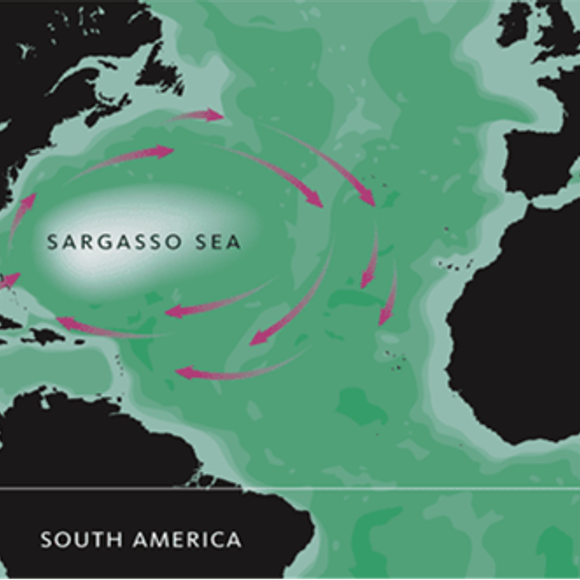
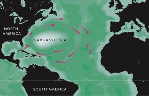
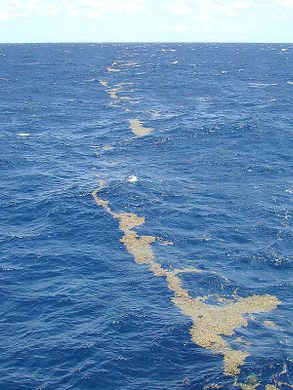
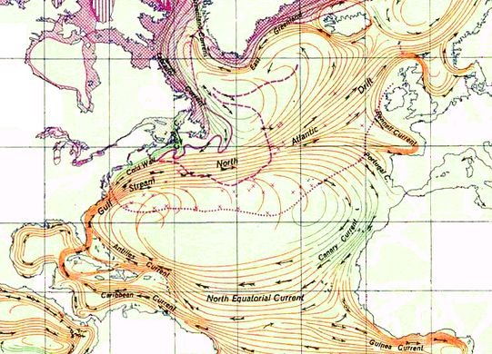
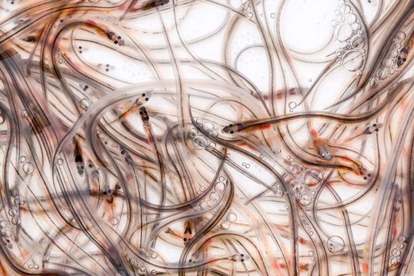
Named after Sargassum, a species of seaweed that covers the area’s waters, the Sargasso Sea is the only sea without shores or coastlines. Instead of being bounded by land, it is defined by four ocean currents. It borders the North Atlantic Current on the north, the Gulf Stream on the west, the North Atlantic Equatorial Current on the south, and the Canary Current on the east. These currents form a clockwise-circulating gyre that surrounds the Sargasso Sea much like a terrestrial coastline would.

In addition to giving the Sargasso Sea this unique geographical claim to fame, the gyre that surrounds the sea also makes for excellent visibility, with warm, dark blue water transparent for up to 200 feet. The Sargasso Sea was even mentioned in Jules Vernes’ Twenty Thousand Leagues Under the Sea. More unfortunately, the stillness of the Sargasso's calm waters allows the sea to trap up to 200,000 pieces of trash per square kilometer in some areas, forming what's been dubbed the North Atlantic Garbage Patch.

Related Tags

Water Sea Oceans Geographic Oddities Borders Underwater Week Recursive Places

Know Before You Go

If you get lost then try these coordinates.. 28° 0′ 0″ N, 66° 0′ 0″ W - bang in the middle of the Sargasso Sea

Community Contributors

Added By

lewblank

Edited By

Shiv, MagnumPI, lampbane, Meg

  • Shiv
  • MagnumPI
  • lampbane
  • Meg

Published

May 1, 2017

Edit this listing

Make an Edit
Add Photos
Sources
  • http://oceanservice.noaa.gov/facts/sargassosea.html
  • https://en.wikipedia.org/wiki/Sargasso_Sea
  • http://mysteriousfacts.com/mystery-of-sargasso-sea-sea-without-shores-or-coastline/
Sargasso Sea
North Atlantic Ocean
34.307144, -66.269531

Related Stories and Lists

Will These Glass Eels Beat the Odds and Survive to Spawn?

animals

By Gemma Tarlach

The Sargasso Sea Is Plenty Wide, and It's Growing

underwater

By Dan Nosowitz

What Do You Call a Moon's Moon?

news

By Sarah Laskow

Related Places

  • Burntcoat Head Park

    Maitland, Nova Scotia

    Burntcoat Head Park

    The highest tides in the world come in and out here twice a day, allowing you to essentially walk along the ocean floor.

  • Visitors at the Kuroshio Sea main tank

    Motobu, Japan

    Okinawa Churaumi Aquarium

    One of the world's largest tanks mimics the experience of watching rare whale sharks, giant rays, and deep sea creatures from the ocean floor.

  • High-def satellite image of third order island

    Nunavut

    Sub-Sub-Sub Island on Victoria Island

    The Arctic Archipelago is home to world's largest third order island: an island in a lake on an island in a lake on an island.

  • Dashed line is an international border; Bangladeshi farmer in foreground

    Panchagarh, Bangladesh

    Dahala Khagrabari

    A piece of India inside a piece of Bangladesh inside a piece of India inside a piece of Bangladesh.

  • Philippines

    Vulcan Point

    An island in the middle of a lake, in the middle of a volcano, in the middle of a bigger lake, in the middle of a bigger island, in an archipelago, in the Pacific Ocean.

  • The brine pool’s “shore” and surface ripples beneath the Gulf of Mexico.

    Mexico

    Undersea Brine Lake

    A lake at the bottom of the ocean.

  • The memorial statue

    Cordova, Alaska

    Cordova Fisherman’s Memorial

    A small maritime town's own way of memorializing the local lives spent at sea.

  • Tri-States Monument and Delaware River

    Port Jervis, New York

    Tri-States Monument

    A pair of 19th-century granite markers symbolically record where the state boundaries of New York, New Jersey, and Pennsylvania intersect.

Aerial image of Vietnam, displaying the picturesque rice terraces, characterized by their layered, verdant fields.
Atlas Obscura Membership

Become an Atlas Obscura Member


Join our community of curious explorers.

Become a Member

Get Our Email Newsletter

Follow Us

Facebook YouTube TikTok Instagram Pinterest RSS Feed

Get the app

Download the App
Download on the Apple App Store Get it on Google Play
  • All Places
  • Latest Places
  • Most Popular
  • Places to Eat
  • Random
  • Nearby
  • Add a Place
  • Stories
  • Food & Drink
  • Itineraries
  • Lists
  • Video
  • Podcast
  • Newsletters
  • All Trips
  • Family Trip
  • Food & Drink
  • History & Culture
  • Wildlife & Nature
  • FAQ
  • Membership
  • Feedback & Ideas
  • Community Guidelines
  • Product Blog
  • Unique Gifts
  • Work With Us
  • About
  • FAQ
  • Advertise With Us
  • Advertising Guidelines
  • Privacy Policy
  • Cookie Policy
  • Terms of Use
Atlas Obscura

© 2025 Atlas Obscura. All Rights Reserved.