Trips Places Foods Stories Newsletters
Loading...
Loading...
Loading...
Loading...

No search results found for
“”

Make sure words are spelled correctly.

Try searching for a travel destination.

Places near me Random place

Popular Destinations

  • Paris
  • London
  • New York
  • Berlin
  • Rome
  • Los Angeles
Trips Places Foods Stories Newsletters
Sign In Join
Places near me Random place
All the United States Missouri Jones Confluence Point State Park

Jones Confluence Point State Park

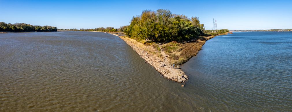
Stand at the point where the two mightiest rivers in the United States converge.

West Alton, Missouri

Added By
Rick
Email
Been Here
Want to go
Added to list
CAPTION
Left Missouri, Right Mississippi   eschie / Atlas Obscura User
  eschie / Atlas Obscura User
  eschie / Atlas Obscura User
  eschie / Atlas Obscura User
Waters meet here   eschie / Atlas Obscura User
  eschie / Atlas Obscura User
Been Here
Want to go
Added to list

About

All rivers go somewhere, and these two monsters meet up right here. The Missouri River is officially 2,341 miles long and at this point, you can stand at its end and watch as its waters mingle with the mighty Mississippi. The Missouri is considered part of the Mississippi River Basin which represents over 40 percent of the drainage of the lower 48 states. It's a unique perspective and a lot of water. 

Although the river beds have changed in two centuries, this is also the point where Meriwether Lewis and William Clark's Corps of Discovery took a left turn and paddled hard upstream, heading west in 1804. 

The actual confluence is surrounded by protected wetlands and is great for bird watching as well, depending on the time of year, as it is part of the Mississippi Flyway. Millions of birds, representing some 60 percent of the bird species in North America, migrate along the Mississippi River corridor every spring and fall.

Related Tags

State Parks Lewis And Clark Geographic Markers Parks Water Rivers

Know Before You Go

The actual point is a short and easy one-quarter mile walk from a parking lot on compacted gravel.

Don't be disappointed, check before going, especially in spring. This park is in a floodplain and may be closed during high water conditions. Also, fair warning, it's quite a site, but it's at the end of four miles of dirt roads. If it's dry weather, don't plan on leaving with a clean car. 

Community Contributors

Added By

eschie

Published

November 15, 2023

Edit this listing

Make an Edit
Add Photos
Sources
  • https://mostateparks.com/park/edward-ted-and-pat-jones-confluence-point-state-park
Jones Confluence Point State Park
1000 Riverlands Way
West Alton, Missouri, 63386
United States
38.819167, -90.119898
Visit Website
Get Directions

Nearby Places

Luna Café

Granite City, Illinois

miles away

Fort Belle Fontaine

St. Louis, Missouri

miles away

American Oddities Museum

Alton, Illinois

miles away

Explore the Destination Guide

Photo of Missouri

Missouri

United States

Places 178
Stories 6

Nearby Places

Luna Café

Granite City, Illinois

miles away

Fort Belle Fontaine

St. Louis, Missouri

miles away

American Oddities Museum

Alton, Illinois

miles away

Explore the Destination Guide

Photo of Missouri

Missouri

United States

Places 178
Stories 6

Related Places

  • Entrance gate to the Walker River State Recreation Area.

    Yerington, Nevada

    Walker River State Recreation Area

    Nevada's second-newest state park offers camping, fishing, hiking, and river float trips.

  • The headwaters at Lake Itasca

    Lake Itasca, Minnesota

    Headwaters of the Mississippi River

    At this Minnesota state park you can easily wade across the source of the mighty Mississippi.

  • Geneva, Switzerland

    Pointe de la Jonction

    Where two rivers meet—but don’t mix.

  • Missouri Headwaters State Park

    Three Forks, Montana

    Missouri Headwaters State Park

    The source of America's longest river is also a historical landmark and the start of a famous nude run.

  • Sioux Falls Park

    Sioux Falls, South Dakota

    Falls Park

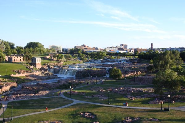
    More than 7,000 gallons of water pour over these cascading red quartzite waterfalls every second.

  • Wendell, Idaho

    Niagara Springs

    An impressive waterfall nestled in the cliffs of Idaho's Snake River Canyon.

  • The river alongside Larkin Plaza

    Yonkers, New York

    Saw Mill River Daylighting

    A waterway covered over after the Industrial Revolution has been unearthed and cleaned up, for the enjoyment of fish and humans alike.

  • Lift Pool and Lock No. 1

    Alexandria, Virginia

    Alexandria Tide Lock Park

    Long buried under the 20th-century landscape, this lift lock of the Alexandria Canal is the lone remnant of an ambitious early American transportation project.

Aerial image of Vietnam, displaying the picturesque rice terraces, characterized by their layered, verdant fields.
Atlas Obscura Membership

Become an Atlas Obscura Member


Join our community of curious explorers.

Become a Member

Get Our Email Newsletter

Follow Us

Facebook YouTube TikTok Instagram Pinterest RSS Feed

Get the app

Download the App
Download on the Apple App Store Get it on Google Play
  • All Places
  • Latest Places
  • Most Popular
  • Places to Eat
  • Random
  • Nearby
  • Add a Place
  • Stories
  • Food & Drink
  • Itineraries
  • Lists
  • Video
  • Podcast
  • Newsletters
  • All Trips
  • Family Trip
  • Food & Drink
  • History & Culture
  • Wildlife & Nature
  • FAQ
  • Membership
  • Feedback & Ideas
  • Community Guidelines
  • Product Blog
  • Unique Gifts
  • Work With Us
  • About
  • FAQ
  • Advertise With Us
  • Advertising Guidelines
  • Privacy Policy
  • Cookie Policy
  • Terms of Use
Atlas Obscura

© 2025 Atlas Obscura. All Rights Reserved.