Alaskans Have Photographed This Boulder for 33 Years
In 1990, a scientist began visually documenting Prince William Sound’s recovery from the Exxon Valdez oil spill. When funding ran out, volunteers took over.
This article is from Hakai Magazine, an online publication about science and society in coastal ecosystems. Read more stories like this at hakaimagazine.com.
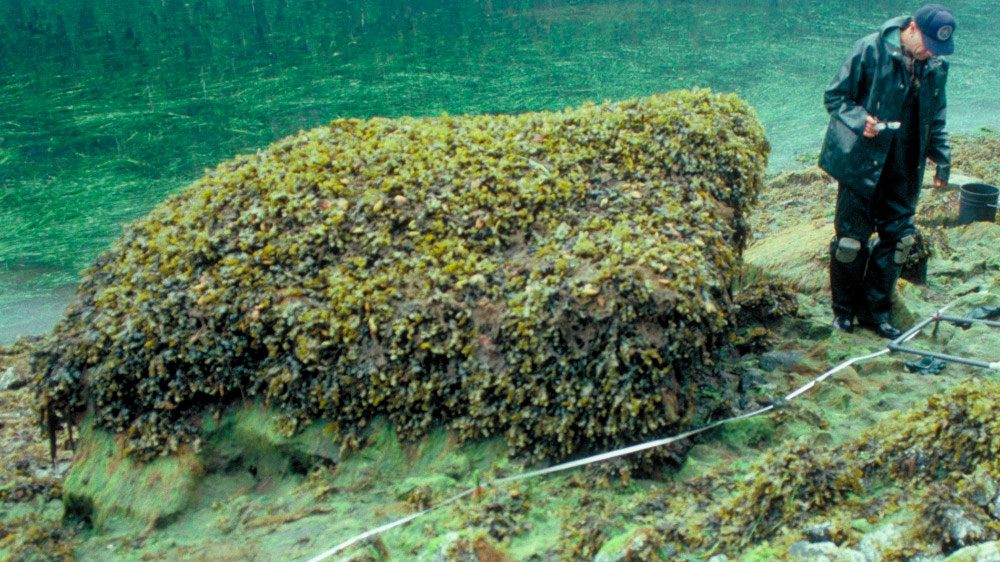
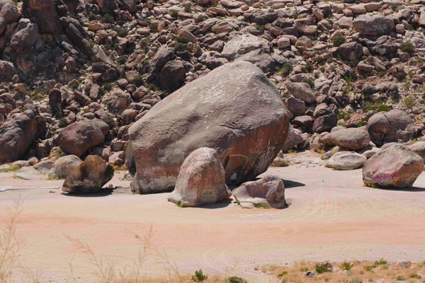
David Janka stands at the helm of the Auklet, an 18-meter charter boat that’s traveled Alaska’s waters longer than the region has been an American state. It’s the peak of summer as he putters into Snug Harbor, a shallow curve in a shoreline of Knight Island walled by towering cliffs and stands of cedar, spruce, and hemlock. He steers toward the beach, aiming for a potato-shaped rock the size of a Volkswagen Beetle. He’s here to take its picture.
For 33 years, someone has traveled here each summer to photograph the unassuming boulder, nicknamed Mearns Rock. Collectively, the photos are an unexpected offshoot of one of the United States’ worst environmental disasters.
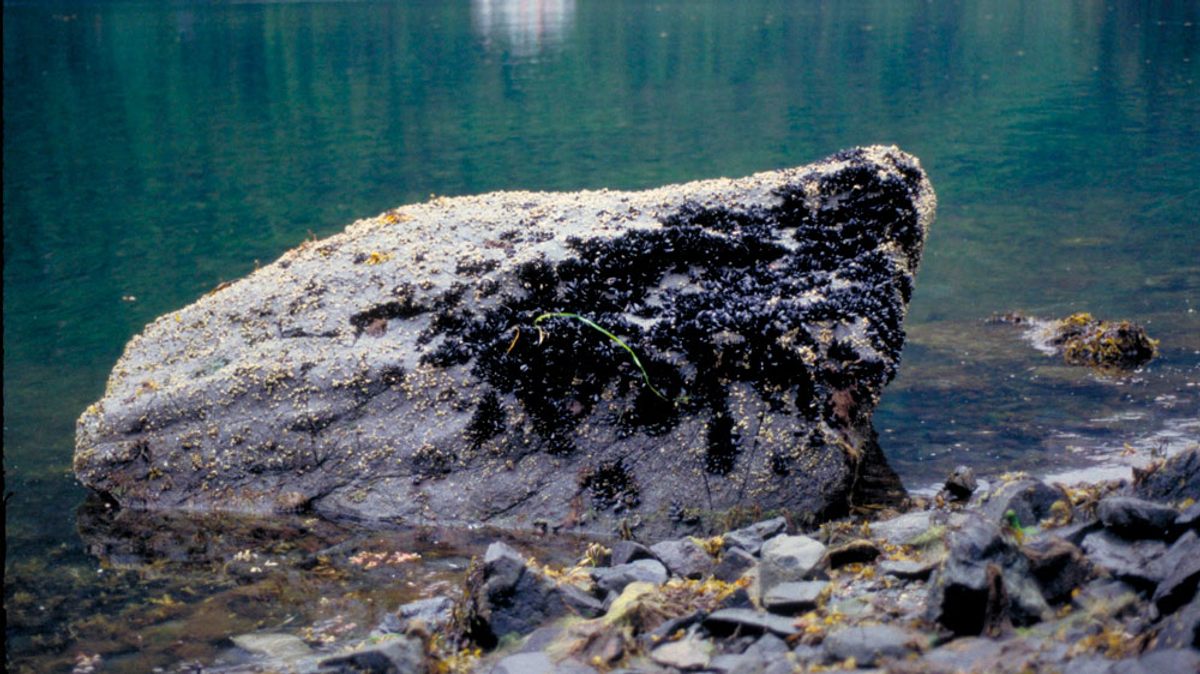
In 1989, the Exxon Valdez supertanker ran aground on Bligh Reef, dumping 40 million liters of thick black crude into Prince William Sound. Oil spread to Snug Harbor, 80 kilometers away. Mearns Rock and all its marine denizens were “totally painted in oil,” says Alan Mearns, the rock’s eponym, who worked on the hazmat team for the U.S. National Oceanic and Atmospheric Administration (NOAA) in the spill’s aftermath.
During the cleanup, Exxon crews power-washed oil off shorelines and into the ocean, where it was easier to corral. But the effort also ripped away marine life.
“Our concern immediately became, ‘Is a cleanup going to be worse than leaving the oil on?’” says Mearns.
In the end, Exxon washed some sections of the coast and left others untreated. Mearns Rock remained oiled. For the next decade, Mearns and a team of chemists and biologists returned to dozens of sites in the region to assess the ecosystem’s recovery from oil exposure and power washing. Mearns started photographing these research visits, using boulders like Mearns Rock as landmarks. When the larger study ended, Mearns and his NOAA colleague John Whitney secured funding to keep taking yearly photos until 2012. Since then, the project has survived on the enthusiasm of volunteers like Janka, who now consistently photograph eight of the original sites, stopping in when they’re nearby. The dedicated group has included skippers, scientists, and local coast guard volunteers.
Side by side, the 33 images of Mearns Rock look like a collection of a child’s yearly school photos. In one, the boulder boasts a thick topper of rockweed. Another year, it’s buzz-cut bare, followed by a stubbly growth of barnacles the next summer. Together, the photos demonstrate the dynamism of the intertidal zone, where mussels, barnacles, and seaweed clamor for real estate.
“There’s a lot that we can learn from a simple picture,” says Scott Pegau, a research manager at the Oil Spill Recovery Institute in Cordova, Alaska. This June, during an aerial herring survey, he’ll dock his floatplane in Shelter Bay, 20 kilometers southwest of Snug Harbor, to photograph two refrigerator-sized boulders named Bert and Ernie.

The decades-long photo series is also helping researchers understand the region’s natural variability, where the intertidal zone changes from boulder to boulder, bay to bay, year to year.
While mussels and barnacles rebounded to natural numbers within a few years of the spill, not all species were so lucky. Several populations still haven’t recovered, including a local killer whale pod. To this day, when Janka has guests on the Auklet, he can stop at certain beaches and find pockets of toxic oil just a spoonful of sand beneath the surface.
Janka has been intimately familiar with the oil spill since the night of the Exxon Valdez wreck. He shuttled journalists into the disaster zone during the five frenzied days after the spill, and he met Mearns when NOAA later hired him to ferry scientists to their sites. Though he retired from chartering this year, Janka plans to return to Mearns Rock to snap another photo this summer.

The Exxon Valdez proved to Janka the power of visual documentation. So many positive things happened because images of the spill were passed around the world, he says. The U.S. government implemented oil spill legislation, formed citizen councils to oversee Prince William Sound’s oil industry, and legislated double-hulled tankers. “I don’t think that would have happened if there weren’t photographs,” he says.
The ongoing project feels less attached to the 1989 oil spill and more focused on the future, says Mearns, who retired from NOAA in 2018 but continues to steward the photo collection. Prince William Sound has made a tentative recovery but could be devastated again. Alaska’s waters are warming, new species are moving north, and rising seas are pushing the intertidal zone up the shoreline. A citizen council just flagged the Valdez oil terminal in Prince William Sound as an “unacceptable safety risk.” Who knows what the next 33 years will bring? The team is actively looking for volunteer photographers to keep the project running.
“I turn 80 this summer. I keep thinking, well, maybe I should back off. But I can’t. It’s fun,” Mearns says. As long as his friends keep sending photos, he’ll keep building the boulder albums, checking out each rock’s latest look as he adds another photo to the end of the line.


Follow us on Twitter to get the latest on the world's hidden wonders.
Like us on Facebook to get the latest on the world's hidden wonders.
Follow us on Twitter Like us on Facebook