Trips Places Foods Stories Newsletters

Take your next trip with Atlas Obscura!

Our small-group adventures are inspired by our Atlas of the world's most fascinating places, the stories behind them, and the people who bring them to life.

Visit Adventures
Trips Highlight
Macchu Picchu
Peru • 10 days, 9 nights
Peru: Machu Picchu & the Last Incan Bridges
from
Central Asia yurt night stars
Uzbekistan • 15 days, 14 nights
Central Asia Road Trip: Backroads & Bazaars
from
View all trips
Top Destinations
Latest Places
Most Popular Places Random Place Lists Itineraries
Add a Place
Download the App
Top Destinations
View All Destinations »

Countries

  • Australia
  • Canada
  • China
  • France
  • Germany
  • India
  • Italy
  • Japan

Cities

  • Amsterdam
  • Barcelona
  • Beijing
  • Berlin
  • Boston
  • Budapest
  • Chicago
  • London
  • Los Angeles
  • Mexico City
  • Montreal
  • Moscow
  • New Orleans
  • New York City
  • Paris
  • Philadelphia
  • Rome
  • San Francisco
  • Seattle
  • Stockholm
  • Tokyo
  • Toronto
  • Vienna
  • Washington, D.C.
Latest Places
View All Places »
The exterior view of the large castle.
Castello di Gropparello (Gropparello Castle)
Night view of the palace with Kathmandu’s famous giant fruit bats flying overhead.
Narayanhiti Palace Museum Massacre Site
Small statues of Buddha line the path to the top of the mountain.
Mitaki-dera
A view of the Sandiaoling bike tunnel.
Sandiaoling Bike Tunnel
Latest Places to Eat & Drink
View All Places to Eat »
The local catch is delicious fried as well.
Terry's of Charlevoix
Carlson’s Fishery is a Great Lakes institution.
Carlson’s Fishery
The Cathedral Café maintains the building’s original church exterior.
Cathedral Café
Exterior of the historic Dyffryn Arms pub.
Dyffryn Arms
Most of what’s on the menu here comes from Michigan.
The Glenwood
Recent Stories
All Stories Video Podcast
Most Recent Stories
View All Stories »
Cely’s map is not only accurate, but captures the unique characteristics of Congaree’s trees and waterways.
How One Biologist Drew a Hyper-Accurate, Ranger-Approved Map of Congaree National Park
Though they’re protected inside the park, wolves can be killed when they cross its borders.
Wolves Have a Bad Reputation. One Yellowstone Naturalist Is Trying to Fix It.
Passersby stop to admire the punny offerings of Brooklyn’s only dinosaur bodega.
We Visited the Dino Bodega in (Jurassic) Park Slope
Native Americans have a longstanding, rich, and vibrant culture in Wyoming.
Wyoming’s Sacred Landscapes: A Journey Through Native American History

No search results found for
“”

Make sure words are spelled correctly.

Try searching for a travel destination.

Places near me Random place

Popular Destinations

  • Paris
  • London
  • New York
  • Berlin
  • Rome
  • Los Angeles
Trips Places Foods Stories Newsletters
Sign In Join
Places near me Random place
All São Tomé and Príncipe Marco do Equador
AO Edited

Marco do Equador

The equator passes through this tiny island in the eastern Atlantic.

Ilhéu das Rolas, São Tomé and Príncipe

Added By
Steve Clark
Email
Been Here
Want to go
Added to list
CAPTION
Marco do Equador on Ilhéu das Rolas   Paulacastelli / CC BY-SA 4.0
  Steve 55 / Atlas Obscura User
  Steve 55 / Atlas Obscura User
  Steve 55 / Atlas Obscura User
  Steve 55 / Atlas Obscura User
Been Here
Want to go
Added to list

About

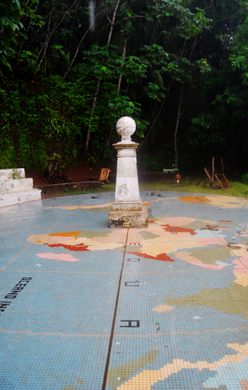
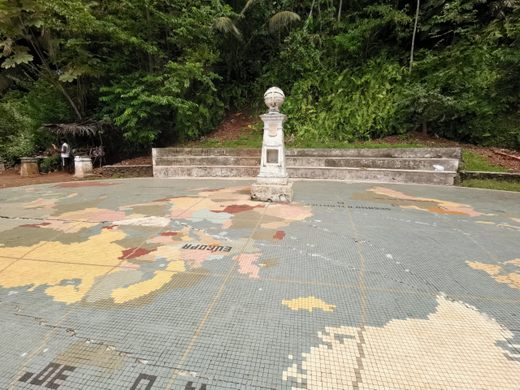
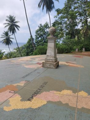
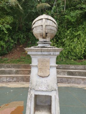
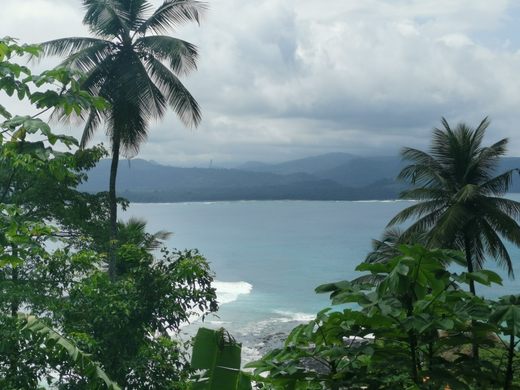
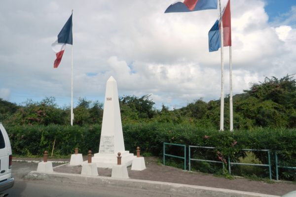
Just south of São Tomé there is a small island called Ilhéu das Rolas. On this little island, you can find a monument marking the location of the equator.

Ilhéu das Rolas covers just two square kilometers (0.77 square miles). It has a small population, and can only be reached by a ferry from the larger island of São Tomé Island, which lies across the Canal das Rolas. Between 1915 and 1918, Portuguese navigator and historian Gago Coutinho traveled to São Tomé on an expedition to map the island, which was at that point a colony of Portugal. During the mapping process, Coutinho observed that the equator crossed Ilhéu das Rolas.

The monument roughly marks the spot where the equatorial line runs through the island, splitting it between the Northern and Southern Hemispheres. The line does not cross exactly at the monument but rather down the hill in the little town below. But the scenic view up the hill lead to the monument being built up there instead of at the precise location.

The ground underneath the monument is covered with a tile mosaic map of the world.

Related Tags

Maps Monuments Geographic Markers Islands

Know Before You Go

To get there you have to get a boat from Porto Alegre

Community Contributors

Added By

Steve 55

Edited By

voyagesimon, Michelle Cassidy

  • voyagesimon
  • Michelle Cassidy

Published

August 29, 2022

Edit this listing

Make an Edit
Add Photos
Marco do Equador
Ilhéu das Rolas
São Tomé and Príncipe
0.0, 6.522074

Nearby Places

Pico Cao Grande

Caue, São Tomé and Príncipe

miles away

Explore the Destination Guide

Photo of São Tomé and Príncipe

São Tomé and Príncipe

Africa

Places 3

Nearby Places

Pico Cao Grande

Caue, São Tomé and Príncipe

miles away

Explore the Destination Guide

Photo of São Tomé and Príncipe

São Tomé and Príncipe

Africa

Places 3

Related Stories and Lists

Our Favorite New Places of 2022

List

By Atlas Obscura

Related Places

  • Monument to the geographic center of Belgium

    Walhain, Belgium

    Geographic Center of Belgium

    This metal monument marking the middle of Belgium represents three regions coming together to form one country.

  • Ras Angela

    Ras Angela, Tunisia

    Ras Angela

    The northernmost point of continental Africa—or is it?

  • Concordia Monument

    Belvedere, Sint Maarten

    Concordia Monument

    Where Saint-Martin ends and Sint Maarten begins (or vice versa).

  • A PIRATA weather buoy, the only thing that is really at Null Island.

    Null Island

    A busy island at the center of the world that doesn’t actually exist.

  • The monument’s front.

    East Liverpool, Ohio

    The Starting Point of the U.S. Public Land Survey

    After covering almost 1.5 billion acres, the survey's still not finished.

  • Detail of the Mini Monument

    Washington, D.C.

    Washington Mini Monument

    There's a 12-foot-tall replica of the Washington Monument hidden under a manhole nearby.

  • Écaussinnes, Belgium

    ‘Bonhomme de Fer’ (‘The Iron Man’)

    This human-shaped statue is actually a geodesic station.

  • Tri-States Monument and Delaware River

    Port Jervis, New York

    Tri-States Monument

    A pair of 19th-century granite markers symbolically record where the state boundaries of New York, New Jersey, and Pennsylvania intersect.

Aerial image of Vietnam, displaying the picturesque rice terraces, characterized by their layered, verdant fields.
Atlas Obscura Membership

Become an Atlas Obscura Member


Join our community of curious explorers.

Become a Member

Get Our Email Newsletter

Follow Us

Facebook YouTube TikTok Instagram Pinterest RSS Feed

Get the app

Download the App
Download on the Apple App Store Get it on Google Play
  • All Places
  • Latest Places
  • Most Popular
  • Places to Eat
  • Random
  • Nearby
  • Add a Place
  • Stories
  • Food & Drink
  • Itineraries
  • Lists
  • Video
  • Podcast
  • Newsletters
  • All Trips
  • Family Trip
  • Food & Drink
  • History & Culture
  • Wildlife & Nature
  • FAQ
  • Membership
  • Feedback & Ideas
  • Community Guidelines
  • Product Blog
  • Unique Gifts
  • Work With Us
  • About
  • FAQ
  • Advertise With Us
  • Advertising Guidelines
  • Privacy Policy
  • Cookie Policy
  • Terms of Use
Atlas Obscura

© 2025 Atlas Obscura. All Rights Reserved.