GPS Doodles Turn Your Workout Into an Art Project
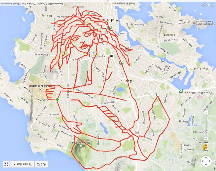
One imagines that painting this siren’s hair was a bit laborious. (All images: Stephen Lund)
Stephen Lund considers the Canadian city of Victoria his canvas and a bicycle his brush. And the paint? Strava, a GPS tracking system which marks his routes with crimson lines.
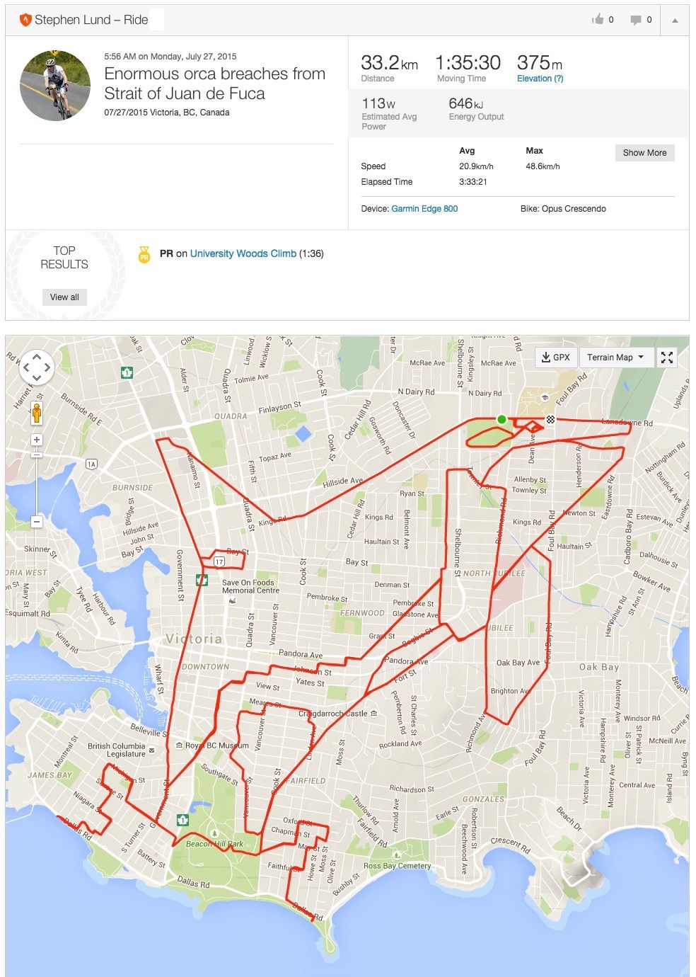
So far, he has pedaled around in the shapes of critters such as an angler fish, giraffe, giant anteater, and nine-banded armadillo; mythical and interplanetary creatures such as the Siren of the Salish Sea, the Sea Serpent of Haro Strait, and the Dark Lord of the Sith. Other bike-route masterpieces include a stegosaurus and Queen Victoria.
Each one takes Lund up to a day to complete and requires pedaling an average of 70 kilometers.
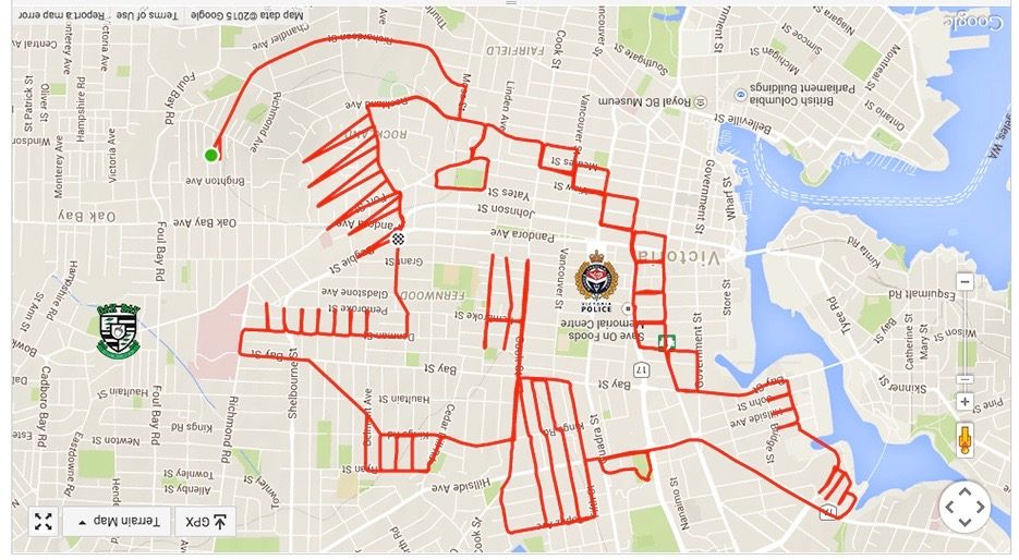
This angler fish has escaped onto land.
Lund calls his creations “GPS Doodles.” Others have used the term “Strava art,” Strava being a GPS program that enables riders and runners to track, analyze, and quantify their workouts. Strava’s data generates a thin red line that traces every move an athlete makes on a map.
Lund saw creative potential in that line, and thus GPS doodling was born. “It gave me a way to inject a sense of purpose into my rides, a way to disguise exercise as urban exploration and creative expression, a way to make exercise fun,” Lund explained at a talk at TEDxVictoria.
He began doodling in early 2015, soon responding to suggestions and requests; by the year’s end, he’d created 70 doodles and logged hundreds of kilometers in the process.
Strava provides information on distance, time, speed, and elevation in addition to a visual of the route.
To create a GPS Doodle, Lund begins by sketching out his route on a digital map, whether a kangaroo, a Valentine’s message for his wife, or a response to demands for “Strava porn” from a member of his bike club.
Sometimes the images emerge naturally out of the terrain, and other times he needs to work hard to discover them within the road-scape (to create cleavage for the aforementioned “porn” doodle, he had to slog through ankle-deep water). He then sends a PDF version of the map with the drawing to his phone, to use as a guide while he rides.
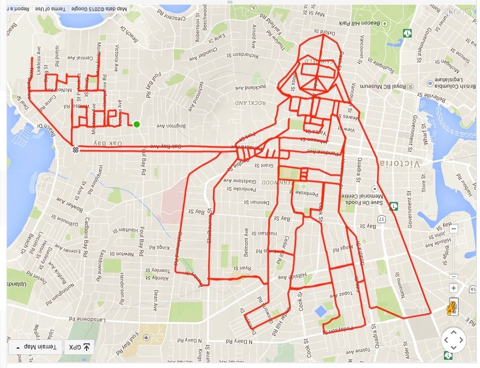
Perfect for Star Wars cycling fans.
At first, Lund kept the tracking system on at all times in one long, uninterrupted brushstroke. However, to achieve greater detail and overcome certain obstacles, Lund began to turn the device off and on, a technique allowing for the creation of straight lines connecting two points.
On his blog, Sketchbook of a GPS Artist, he includes some tips: explore unfamiliar areas in advance, draw carefully, since there’s no eraser (that red line can’t be retracted), and brace yourself for imperfection—after all, it’s a tricky medium. He also advises others to prepare for a long outing.

What’s up David?
“I’ve bush-whacked through brambles, scrambled over chain link fences and skidded down muddy hillsides,” he writes on his blog. “Often, my Strava art feels more like a military training exercise than a cycling activity.”
On his blog, you’ll find several posts a week, sprinkled with dad jokes and dorky descriptions. Regarding a newly drawn sea serpent, he reports, “Rising up out of Haro Strait with a neck nearly 10 kilometers long, she was spotted today munching seaweed over Victoria’s downtown area.”

One wrong turn down half a block, and this maze would have been ruined.
These days, GPS art is becoming increasingly popular with runners (the Instagram account of one practitioner, who specializes in doodling male genitalia, has over 13,000 followers). If you’re interested in flexing both your muscles and creative juices, you can download GPS-a-Sketch, a new app that describes the Earth as “a giant sketching toy.”
Map Monday highlights interesting and unusual cartographic pursuits from around the world and through time. Read more Map Monday posts.


Follow us on Twitter to get the latest on the world's hidden wonders.
Like us on Facebook to get the latest on the world's hidden wonders.
Follow us on Twitter Like us on Facebook